Cold air will remain entrenched over Southern Manitoba for the remainder of this week, until a large scale pattern shift once again brings warmer than normal temperatures to our area.
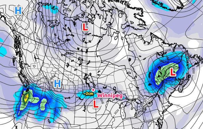
Snow will taper off by early afternoon today as an arctic high pressure system builds into Southern Manitoba as it pushes across Southern Alberta and Saskatchewan. Much of Southern Manitoba will see a total of around 2cm of snow when all is said and done, with a few localities along the international border seeing 2-4cm.
The big story over the next couple days will be the ridge building across the Prairies. Southern Manitoba will see the coldest temperatures of the winter with daytime highs continuing to be well below normal.
The average daytime high for the 18th of January is -13°C. The average overnight low for the same day is -23°C. Winnipeg will experience temperatures close to 10°C colder than average over the next few days.
This high pressure system has brought bitterly cold temperatures to Alberta & Saskatchewan, with daytime highs of only -29°C in Calgary, -28°C in Edmonton and Saskatoon, and -27°C in Regina yesterday. This air mass will push into our region today, which will limit our daytime high to about -23°C and bring us our first overnight low below -30°C tonight.
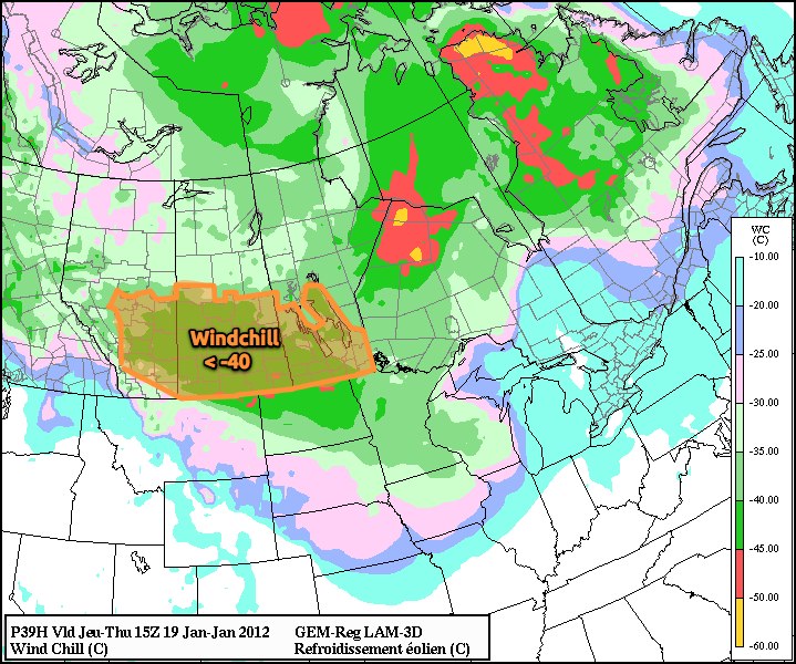
Attached to this cold arctic air mass will be increasing northwest winds to 20km/h, which will produce bitter wind chill values below -40 overnight Wednesday and through much of Thursday morning. At those values, exposed skin can freeze in 5 to 10 minutes, so be sure to dress warm!
Why don’t wind chill values have a °C attached?
Wind Chill is a value calculated from a complex equation that takes the air temperature, the wind speed, and some empirically calculated values for heat transfer through skin into account. When the calculations are done, the units cancel out, and you’re left with a unit-less number. So while the equation was tweaked to produce numbers that resemble temperatures, they aren’t!
If the current forecast works out, it’s likely that we’ll see a large portion of the Prairies covered with wind chill warnings Thursday morning. Little changes for Friday, so there’s a good chance we’ll see another repeat of exceptionally cold daytime highs and bitter wind chills at night.
Current forecasts show a pretty substantial area of warm air pushing into the Southern Prairies on the weekend, bringing daytime highs up by 10 to 15°C. Combined with the CPC’s new forecast of above normal temperatures returning to Southern Manitoba, it doesn’t seem like this winter spell is long to stay.