Powerful Tornado Devastates Moore, Oklahoma
As you may have heard through media reports these past few days, Oklahoma was subject to severe tornadic weather this week which resulted in catastrophic and tragic consequences for many. Supercells posed a threat to residents as they dropped a number of large tornadoes – including a historical tornado that struck Moore on Monday, May 20th. A longwave trough (same as talked about in last week’s EIWN) was in place on the west coast as were other factors that made the conditions ripe for strong, long tracked tornadoes.

Moore, with a population of over 50,000, is located in the heart of Tornado Alley and has been struck directly by tornadoes 3 times in the past 15 years. The fact that they are situated where moist air comes in from the Gulf of Mexico and where a source of dry air from the south-west US not too far away, causes many dryline setups in mid-late spring – ideal conditions for triggering storms.
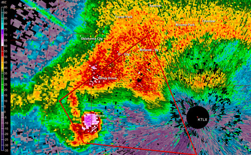
On May 20th, storm cells fired up early in the afternoon and quickly became supercellular and well organized with rotation. As the supercell approached the Moore area, a hook echo formed and not long after, a debris ball could be seen on radar just before it was passed over Moore – it was obvious that Moore was in dire trouble and a tornado had touched down. Thankfully, the National Weather Service in Norman provided generous lead time of 16 minutes before the tornado entered Moore, certainly saving many lives.

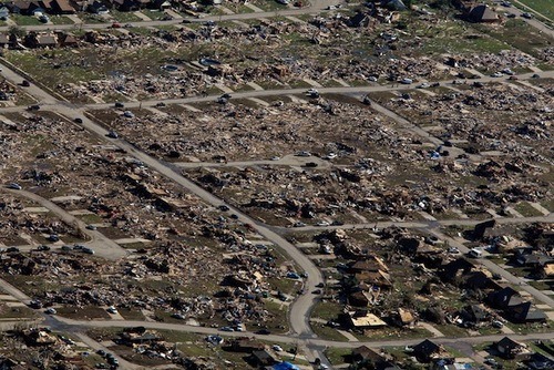
Tragically however, even though advance warnings were given, 24 people perished that day. In some areas it was not possible to take refuge in interior rooms; EF-5 winds easily ripped apart any building in the tornado’s path. Damages are estimated to be in the billions of dollars with an estimated 1,300 homes destroyed and countless number of vehicles wrecked.
It appears the storm track will remain active with troughing across the western part of the continent and intermittent shortwaves rounding down the ridge across Southern US. Severe weather looks likely in the High Plains region of the US (Nebraska, Kansas) in the coming week – not out of the ordinary for these locations at this time of the year.
