Unseasonably warm weather will settle in over Southern Manitoba over the next few days with daytime highs soaring 7–8°C above the normal 12°C for this time of year. Week’s end will bring unsettled weather into the province as a low pressure system lifts northwards out of the Central Plains of the United States.
19°C / 7°C
Mainly sunny with a few cloudy periods in the afternoon.
19°C / 12°C
Increasing cloud through the day. Chance of showers in the evening.
18°C / 8°C
Cloudy. A few showers likely.
Today & Tomorrow
We’ll see a very pleasant day today with a high around 20°C and bright sunny skies light winds out of the southwest. We may see a little afternoon cloud, but nothing too significant. Tonight will be a fairly seasonable night with mostly clear skies and a low near 7°C.
Tomorrow will start off mostly sunny, but we’ll see some scattered cloud through the day and by late in the day we’ll start to see more organized cloud cover starting to push into the Red River Valley from North Dakota. There will be a slight chance of a shower through the evening hours as a warm front lifts north through the Red River Valley & Interlake regions but no significant accumulations are expected in our region.
An Unsettled Friday
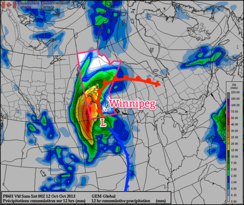
Friday will most likely end up a somewhat unsettled day as a low pressure system tracks through the Red River Valley. This disturbance will bring a fair amount of rain to Western Manitoba; at this point it looks like close to 40–50mm will fall near the Saskatchewan border. Here in the Red River Valley rainfall will be lighter and more disorganized in nature. We’ll see a decent chance of some light scattered showers through the Red River Valley through the day under cloudy skies. The temperature should climb to around 18°C as we sit just on the warm side of the main frontal boundary of this system.
We’ll likely see the bulk of the rain we receive on Friday night and Saturday as we move onto the back-side of the system and a large area of wrap-around precipitation hangs back over the Red River Valley. At the moment, models are forecasting total accumulations around Winnipeg to be anywhere from 5–15mm by the end of Saturday. Until then, we have a couple nice days ahead so get out there and enjoy them!

