A muggy and increasingly unstable air mass will bring heavy showers and thunderstorms to Southern Manitoba this weekend; the “where” is nigh-impossible to predict.
The last few days has seen increasingly warm and humid air building into the Southern Prairies and today will mark the transition in Southern Manitoba into the new air mass. Unfortunately, the large-scale weather pattern will be very slow-moving and result in several days of showers which, thanks to the ample humidity, will certainly be very heavy at time.
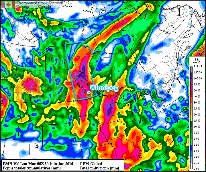
Due to the disorganized nature of the showers, it’s impossible to say where exactly is going to see the most rain; that will only become clear as events unfold and each successive round of showers develops. Overall rainfall totals will fall into a huge range; some places may see only 5-10mm or less by the end of the weekend, while others may see anywhere from 50-100mm…or more?
We’ll go day by day and outline the most likely scenarios and what you can generally expect. Due to the high water levels through much of Southern Manitoba, we’ll be a little generous with our “slight risk severe” area due to sensitivity to rainfall (especially large quantities in short duration). We’ll make a small note on our convective outlooks to highlight this as well.
Friday: Heavy Rain in SW Manitoba
Today’s main threat area will be southwest Manitoba where a combination of the remnants of thunderstorm activity from overnight will be moving through this morning and more thunderstorm activity will develop this afternoon and spread eastwards.
This morning will bring two possible areas of showers, the first over southwestern Manitoba as the remnants of the overnight storms in Saskatchewan lift north-northeastwards and the second being a slight chance of some shower or thundershower activity in the Red River Valley.
Skies will be mixed through the day as we head to a high of around 26°C as southerly winds bring in significantly more humid air; dew point values will climb above 20°C through the afternoon, making it feel positively muggy out there.
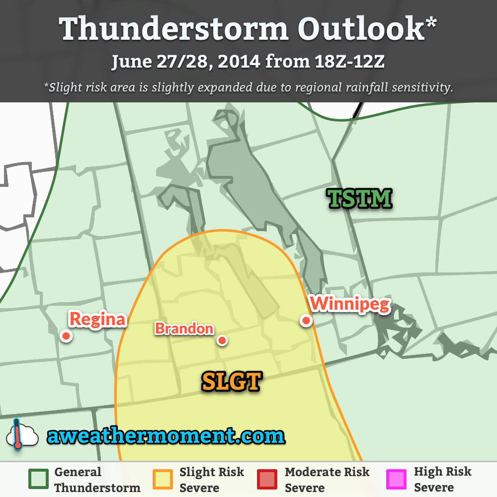
Thunderstorms will redevelop this afternoon over SW Manitoba and spread eastwards through the evening. The main threat from the thunderstorms today will be heavy rain thanks to elevated precipitable water values and likely slow storm motion. Back-building thunderstorms are entirely possible too, which would result in very local areas seeing torrential rains and flash flooding. Marginally severe hail is possible, but the threat would likely be limited to the earlier storms in the day. Other than that, little severe weather is expected. There is a slight chance of funnel clouds over SW portions of the province thanks to relatively high vorticity values ejecting from the base of the incoming upper-level trough and somewhat favourable low-level winds, but conditions don’t look favourable for the development of tornadoes.
The thunderstorm activity will expand into heavy shower activity as well overnight as things push eastwards and northwards. Rainfall totals will be highly variable, with some places seeing nothing and others seeing potentially more than 50mm. The heavy rain concern will shift into the Red River Valley for the overnight period. The low will be around 18°C.
Saturday: Wet Weather
Saturday looks to be the wettest day as a low pressure system lifts northwards out of North Dakota into Southern Manitoba, spreading showers throughout much of the southern portions of the province.
The break between tonight’s convection and Saturday’s weather will be short lived as showers — perhaps with some embedded thunderstorms — lift northwards out of the Dakotas into Southern Manitoba. The showers or thunderstorms will be heavy at times and will likely not taper off until closer to the evening. Rainfall totals will wind up somewhere between 10mm and 50mm, highly variable across the region.
The clouds will begin to scatter out overnight, although complete clearing isn’t likely until Sunday. The low will be near 18°C.
Sunday: A Reprieve
Sunday will provide a reprieve from the drenching of the first half of the weekend. The rain activity will remain further north through the northern Interlake and regions adjacent, while further south we see the sun finally make an appearance. Things look dry through the day, although cloud and showers may push through Southern Manitoba through the night as a trough rotates through the region on the back-side of the main low pressure centre.
Winds will be breezy out of the west or southwest on Sunday at around 30-40km/h with gusts to 50-60km/h on top of that. The high will be near 25°C and the overnight low near 14°C.
Cooler Weather Returns for Next Week
Temperatures will return to slightly below normal as cooler air begins to filter southwards on the back-side of the low. Daytime highs will generally be in the low-to-mid 20’s with little chance of rain through the first half of the week.