The weather will take a turn back towards being unsettled this weekend as a weak trough moving through the region brings another round of shower or thunderstorm activity. For the most part, though, it appears that most of the next few days will be quite pleasant.
Today will be a pleasant early summer day with daytime highs around the 23°C mark throughout the Red River Valley with mixed skies – likely leaning towards the cloudier side. Winds will be relatively light at just 20km/h or so out of the southeast. The RRV will see increasing cloudiness overnight with a low near 14°C and winds out of the southeast at 20–30km/h.
Saturday
Saturday is a day fraught with uncertainty. Similar to earlier this week, a disturbance tracking across the Northern Plains of the U.S. will spread rain and thunderstorm activity across North Dakota, while significant uncertainty exists to how far north into Manitoba the precipitation will extend.
Overall, it will be a cloudier day with highs around the 20°C mark. There are several possible outcomes to consider for the day:
- We see a large area of rain move across Southern Manitoba on Saturday morning that produces a wide swath of 1–2” of rainfall. It moves out on Saturday afternoon and we see a slight chance of some evening convection.
- The bulk of the rainfall stays in North Dakota with a disorganized area of showers moving across Southern Manitoba through the day on Saturday.
- The bulk of the precipitation moves through North Dakota while precipitation focuses along a surface trough over Western Manitoba that gradually works its way into the Red River Valley later in the day.
It’s really difficult to tell which outcome will be the correct one at this point; models struggle terribly with systems that are driven by the energy release of thunderstorms; it’s not uncommon to have successive model runs wildly alter precipitation location by over 100km, such as what happened with the system that brushed Southern Manitoba earlier this week.[1]
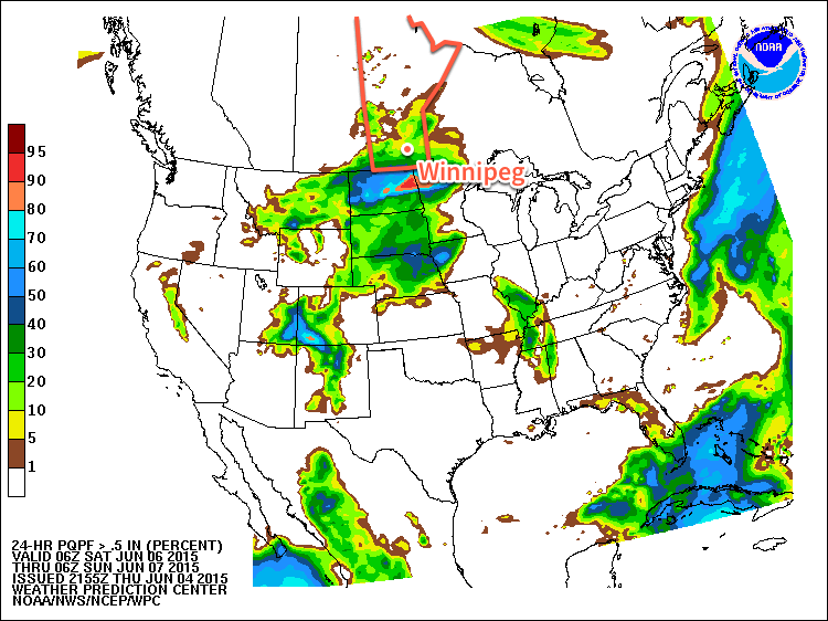
With all the uncertainty regarding what may happen on Saturday, I’d err towards the current HPC 24hr. rainfall probability outlook. This image shows the probability of receiving more than 0.5 inches (13mm) of rain over the 24-hour period. It shows roughly a 20–30% chance for Friday evening through Saturday evening. This would suggest that the heaviest precipitation stays through the Dakotas while further north we see some shower activity with a slight chance of some thunder mixed in. There’s a decent chance of some thunderstorms along the trough line in Western Manitoba in the afternoon, but much of that activity will likely taper off heading towards the Red River Valley.
At this point, though, I wouldn’t rule out all of the precipitation remaining to the west and south of Winnipeg, leaving us with just a cloudy day. We’ll be tracking this system and providing updates in the comments below as things become a little more clear.
Sunday
Sunday will be a fairly nice day with temperatures climbing back into the mid–20’s under mixed skies. There will be a slight chance for some afternoon pop-up shower activity throughout the Red River Valley, but nothing significant is expected. Overall, it looks to be quite a pleasant end to the weekend.
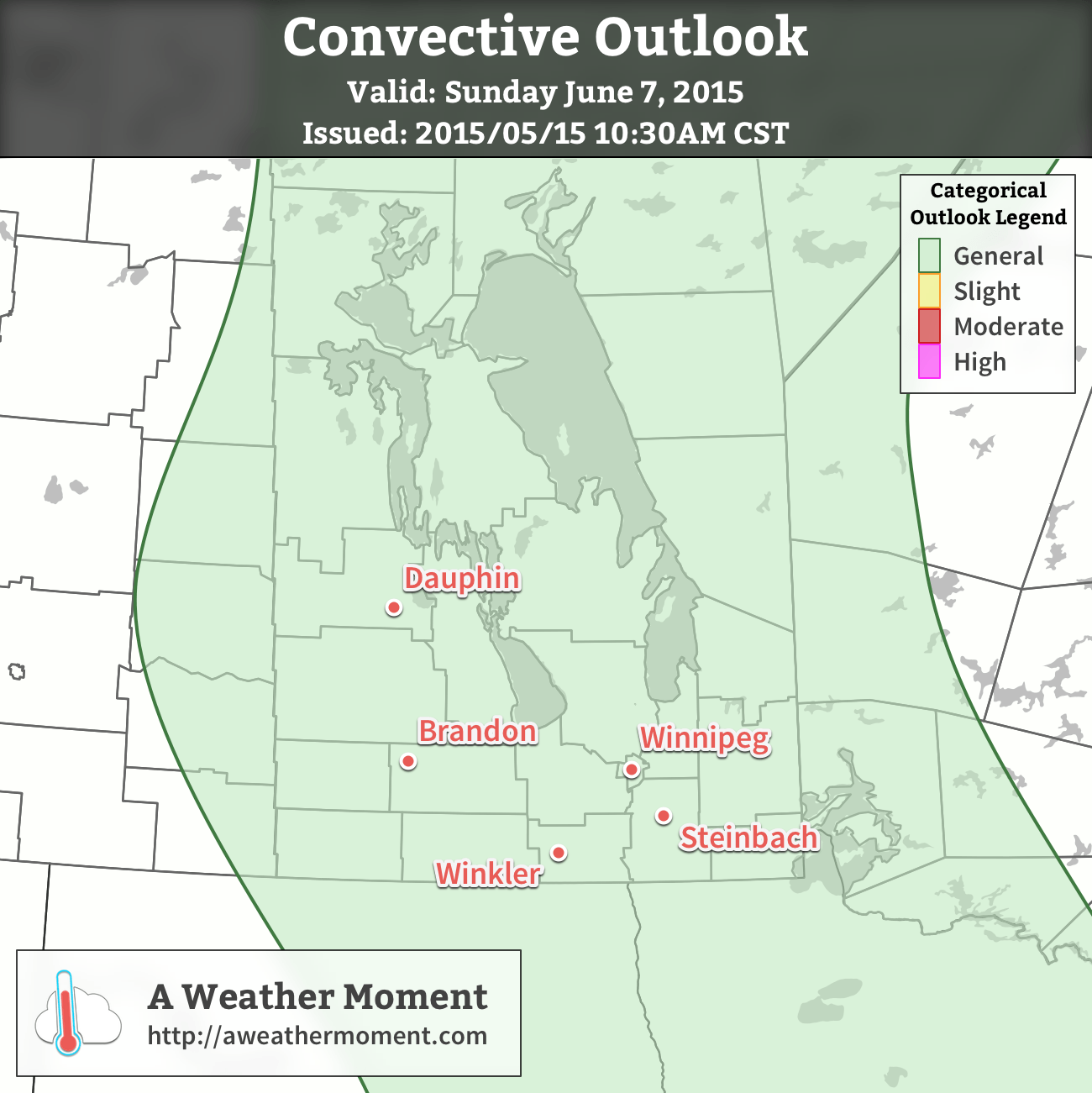
UPDATE: Convective Outlook for Sunday
A risk of thunderstorms exists across much of Manitoba today, including the Red River Valley. Scattered thunderstorms are expected to develop this afternoon as daytime heating, coupled with ample surface moisture, destabilizes the atmosphere. In general, thunderstorms are expected to be non-severe with no organized severe thunderstorm threat. Isolated, short-lived severe storms may be possible, though, particularly along the trough line extending from the Central Interlake southwards through the Red River Valley to the US border.
The overall thunderstorm setup doesn’t look too impressive today. MLCAPE values around 1000-1250 J/kg will have only around 15 kt of 0-6 km bulk shear thanks to a unidirectional northwesterly wind profile with low speed shear through the column. Temperatures are fairly mild through the depth of the column, resulting in skinny CAPE profiles. Moisture is sufficient, with dewpoint values in the 15-17°C range through the Red River Valley. It’s possible that some localized backing of the surface winds may occur near the trough, providing a little more inflow structure to the thunderstorms.
In general, a relatively unimpressive day; with limited energy available and weak focusing, once convection starts, everything will be “fighting for scraps” so to say and it’s quite likely that thunderstorm activity will be very pulse-y: a storm will spike up in intensity for 10-20 minutes then weaken as another one pops up.
With the higher moisture, and slightly more favourable directional profiles along the trough, there’s a small chance for isolated, marginally severe thunderstorms. The main feature of today’s storms will be fairly heavy downpours under them, but the unidirectional shear looks like it will successfully push storms along at a decent clip, so no one location should see a storm for too long, unless it roots on the trough line. For any storm that might become severe, the reason would likely be marginally severe hail at around 20mm (a nickel) diameter.
The weather will calm down this evening and we’ll be heading into a gorgeous summer week!
- The NAM forecast model went from forecasting ≥ 50mm of rain for Winnipeg to 0.5mm on the next run of the model. ↩
Saturday Gradually Comes Into Focus
Some of the uncertainty associated with tomorrow’s weather is beginning to melt away as cards are revealed with the weather in Saskatchewan today.
An area of showers and thunderstorms will develop over southeastern Saskatchewan this evening and slowly push northeastwards. It will likely clip through Virden and then move through Minnedosa eastwards across the Interlake. It seems quite likely that there will be an area of rain or showers extending southwards into the United States. It seems fairly probable that an area of showers will move across the Red River Valley sometime in the morning to early afternoon giving a few mm of rain. Local amounts could be higher if thunderstorms manage to develop along the Trans-Canada Highway & southwards to the border.
That batch of precipitation will clear out midday and then be replaced by a trough moving into the Red River Valley from Western Manitoba. It seems likely that a few thunderstorms will develop along the trough, of which there is a slight chance that one or two could become severe. The eastward extent of these storms is still uncertain, but it’s safe enough to say at this time that there’s likely a slight chance of a thunderstorm late in the afternoon here in Winnipeg. It does look like the northern Red River Valley into the Interlake would be more likely to see thunderstorms than the southern Red River Valley.
We’ll continue to monitor this system as it develops and provide more updates here in the comments!