Today is off to a cold start after a cold front passed through the Red River Valley yesterday morning, ushering in winds up to 70km/h and some mixed-phased showers as the cooler air mass moved into the region. The cool-down will be short-lived, fortunately, as seasonal to above-seasonal temperatures will return for today & through the weekend.
Today and tomorrow’s dominant weather feature will be a ridge of high pressure that will move through the region over the coming two days. With it in place, daytime highs will be cool at a seasonal or slightly below-seasonal 9–10°C. Winds will be light, and both tonight and tomorrow night will see overnight lows dipping below the freezing mark to around –2°C.
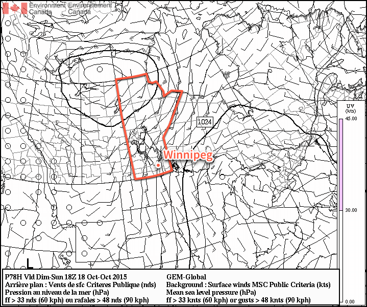
Sunday will see a sunny start to the day, but a bit of cloud push in for the evening and overnight hours. The biggest weather issue of the day will be strong southerly winds that develop as surface winds accelerate out of the ridge of high pressure to our east and are aided by the strong temperature gradient as warmer air moves in aloft.[1] As such, winds will increase–likely midday–to around 40–50km/h out of the south with some gustiness on top of it. It won’t be severe-level winds, but it will certainly be a windy fall day. Temperatures will be slightly warmer at around 14°C, kept lower than the air moving in over us would suggest by the cool outflow winds at the surface.
The winds will taper off in the evening and temperatures will head to around 6°C for an overnight low under partly cloudy skies.
The Week Ahead
Next week is looking fairly unremarkable for the most part. There appears to be a slight chance of some rain mid-week, and other than that, it’s nothing but sunny to partly cloudy skies and seasonal to slightly above-seasonal temperatures. Lovely weather for the second half of October.
- Additionally, multiple models indicate the likelihood of enhanced anticyclonic curvature to the pressure gradient over the Red River Valley which, if true, will act to enhance the wind speeds. ↩
The windy conditions we called for today have developed over the Red River Valley with gusty southerly winds as high as 60km/h. While it’s nice to be right in your forecast, there’s something I’ve noticed that I wanted to draw attention to.
A few weeks ago my favourite iOS weather app, Degrees, stopped working. I’m not sure if the developer has closed up shop or not, but I’m not holding my breath for it to return. I’ve tried several other weather apps that utilize observations & data from Environment Canada, but none have presented the data in a way that has left me satisfied.
Looking further, the weather apps with the best user interfaces, by far, utilize model data for their forecasts. Some of the most innovative utilize forecast.io as their data source, but several others also present forecasts through extraction of model data (such as the Weather Underground app). While the interfaces are great, I’ve found the forecasts–and current conditions, surprisingly–lacking.
The problem is that there are a ton of situations where the models simply can’t forecast correctly. Today’s winds, for example, were under-forecast by everything except the GFS (and it’s probably a fluke as much as skill it pumped the winds high enough). Some models had the winds as low as 20-30km/h today. In the image attached I’ve shown to examples; one using forecast.io’s wind forecast and another showing Weather Underground’s.
The problem is that the boundary layer–that’s where we live–is complicated and there are many things that can modify the weather produced by the synoptic (read: large-scale) weather setup. A forecaster; that is a human being with strong conceptual models of meteorology joined to experience and knowledge of local effects, can routinely outperform almost any model forecast by knowing when, and how, to accept, dismiss, or ignore output.
If you stopped by the blog before today and saw your wind forecast, I’m relieved it worked out. If you relied on a weather app that under-forecast the winds and were wondering why it was so windy today? Well, there are still some jobs that humans are better than computers at.
Footnote: Computers have vastly increased our skill in forecasting the weather; I would argue that a forecaster’s true skill is supplying incremental (sometimes small, sometimes large) added accuracy, precision and value to the “starting point” model output.