A series of low pressure systems will bring two rounds of unsettled weather to the province before calmer weather moves in for the second half of the week.
Today will be a continuation of the humid weather that moved into the region on the weekend with muggy dewpoint values near 18°C persisting as temperatures climb to a high near 27°C. Skies will remain mostly cloudy through the day, although a few sunny breaks might be seen.
The main weather focus for the day will be thunderstorm potential. Any remaining thunderstorm activity from overnight will clear out this morning, but it won't be much of a reprieve before a new batch of thunderstorms develop along a slow-moving cold front sweeping across the Red River Valley. There will be a slight risk of severe thunderstorms with today's activity; primary threats will be large hail and torrential downpours, but a smaller threat of damaging winds also exists.
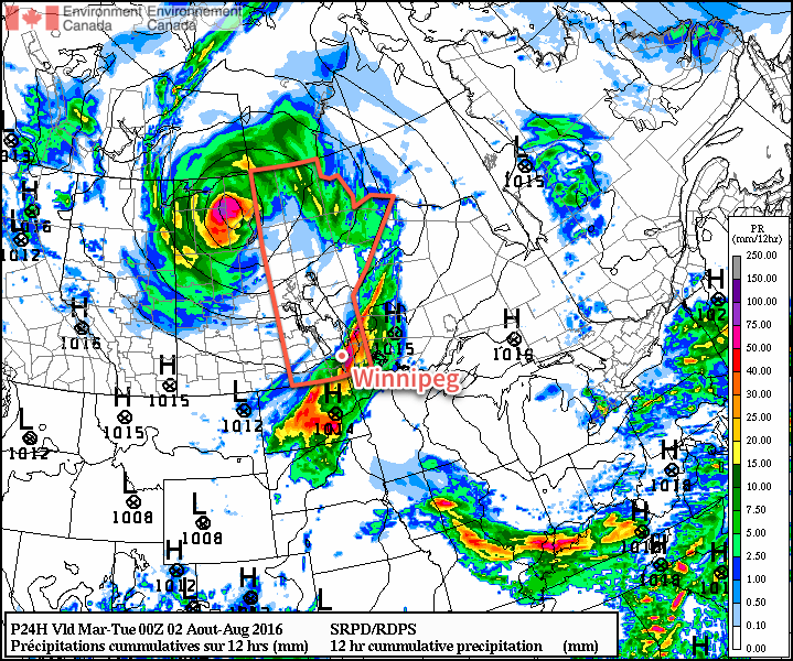
The thunderstorm activity will clear out through the afternoon and evening hours from northwest to southeast across the Red River Valley & SE Manitoba. Skies will clear out, temperatures will drop to a low near 16°C, and the humidity will begin to be flushed out overnight.
Tuesday will be a beautiful day throughout the Red River Valley as temperatures climb to a high near 29°C. Winds will be breezy out of the west at 20-30 km/h. Expect a low near 16°C on Tuesday night.
The weather on Wednesday will be under the influence of the next low pressure system moving into the region. Through the day, showers will begin spreading into Southern Manitoba beginning in the southwest corner of the province in the morning, spreading into the Red River Valley through the afternoon, and then onwards towards the Ontario border in the evening.
There's still quite a bit of uncertainty on the main precipitation swath, so we'll be keeping an eye on this one as it develops. That said, best indications are for the heaviest accumulations over Parkland Manitoba with up to 25-30 mm of rain, and then lesser amounts south and eastwards as the rainfall takes on a more transient nature.
Long Range
The remainder of the week and heading through the weekend looks quite dry with mostly sunny skies and daytime highs in the mid-20's, so after the system clears out on Thursday morning, there should have plenty of pleasant days ahead!
Winnipeg’s seasonal daytime high is currently 26°C while the seasonal overnight low is 13°C.
Great detailed weather…thanks. Especially glad to hear the humidity will clear out overnight! Nice to know the timing of the weather fronts too….thanks
Thanks for the kind words! Unfortunately, the humidity is back with a vengeance tomorrow…
Severe thunderstorms are once again possible tomorrow (August 3rd) over Southern Manitoba as a low pressure system moves into the region. There will be a widespread, slight risk of severe thunderstorms capable of producing large hail and/or damaging winds.
Over the southwest corner of the province, an moderate risk exists for very large hail and damaging winds, as several weather features overlap to produce very structured storms with large amounts of energy. A conditional threat for tornadoes will exist in this region as well, dependent strongly on how much thunderstorm or rain activity develops overnight as this system moves eastwards. If little activity develops and the area is able to see sunshine much of the day, the potential for a significant tornado exists. Anyone in this area should take extra effort to keep alert to any watches or warnings issued by Environment Canada tomorrow.
Additionally, tomorrow will bring a return to humid conditions across the province with dewpoints expected to rise back into the 20’s creating muggy conditions that will feel like the mid- to upper-30’s.