Temperatures will remain above-normal through the second half of the week in what has been an extremely abrupt transition from 10 days of below-normal temperatures when the temperature soared 29°C from a low of -30.5°C on Sunday morning to a high of -1.5°C on Monday afternoon. Other than some brief snow early today, the remainder of the work week will be quite pleasant with a fair amount of sunshine on tap. Christmas, however, may end up being notably worse with a second major snowstorm for December possible.
This morning will bring some light snow to Winnipeg as a shortwave rolls through the Red River Valley. The snow should taper off by mid-morning with accumulations anywhere from 1-2 cm along the Trans-Canada Highway up to 5-6 cm near the U.S. border. As the snow moves out, the cloud will break up and we’ll head into a fairly sunny afternoon with a high near -7°C. Winds will become westerly behind the low to around 20-30 km/h with some gusts on top of that. Expect the winds to continue overnight as skies remain mainly clear and temperatures drop just a couple degrees to a low near -9°C.
Thursday will be a beautiful December day with just a few clouds around and a high near -2°C. Winds will continue at 20-30 km/h, however they will be more southwesterly than westerly. Winnipeg will see a bit of overnight cloud as temperatures dip to a low near -8°C.
Winds will continue out of the west to southwest on Friday as temperatures climb to a high near -5°C under partly cloudy to mixed skies. Skies will be mixed to cloudy on Friday night with a low near -14°C.
Christmas Blizzard Possible
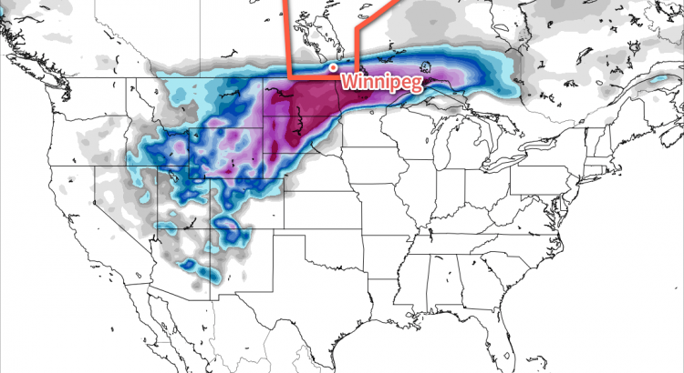
Long-range models have been very consistent in producing a very potent winter storm over Southern Manitoba, the Dakotas, and Minnesota beginning overnight on Christmas Eve and continuing through Christmas Day and into Boxing Day.
There is still significant uncertainty in areas that will be impacted by this storm. The only confidence at this point is that a major winter storm will likely occur somewhere in Central North America on Christmas.
While the location of the system differs between models, a common theme is that all are forecasting 20-50 cm of snow in the worst-hit areas of the storm.
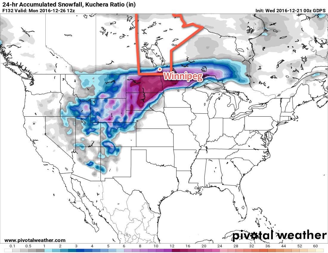
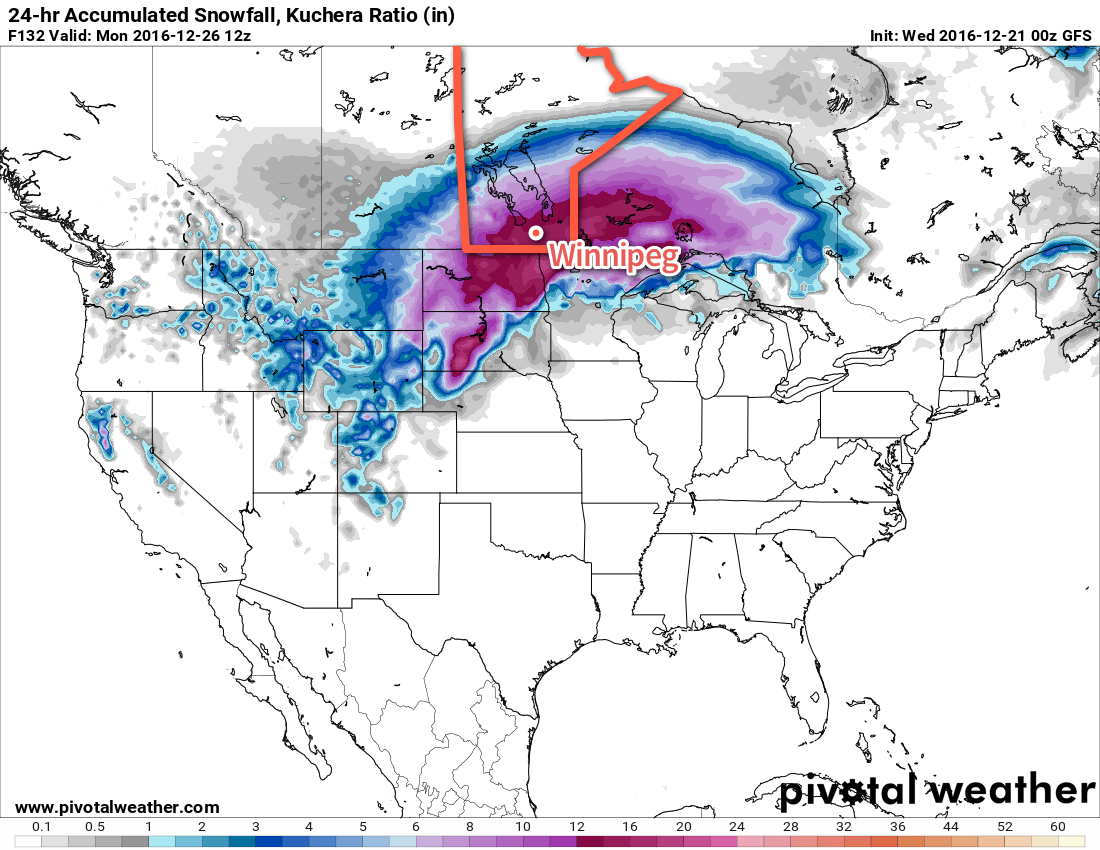
Shown here are the Canadian (GDPS) and American (GFS) long-range forecasts for snowfall accumulated in a 24 hour period between 6AM Christmas Day and 6AM on Boxing Day. Both systems have a core of heavy snowfall greater than 30 cm, however where that occurs is in different places and across varying swath widths.
In general, I’m more partial to the GDPS solution as it creates a sharp deformation zone along the northern track of this system (which tends to happen) and concentrates the heaviest snow through a smaller corridor. Both these features are more physically realistic. That does not mean that I think the GDPS is right, though. Just that it seems to have a slightly more realistic handle on this system. Should the GDPS solution come to fruition, the biggest challenge would be where exactly that northern edge of the precipitation sets up.
While it’s too early to suggest any concrete plans, it would be prudent to have a “Plan B” ready if your Christmas involves travel. The heavy snow will be accompanied by strong northerly winds, likely producing widespread blizzard conditions. In areas hit by this storm, highway travel will likely be nearly impossible and air travel will likely be heavily delayed or cancelled. It seems fairly likely that travel through North Dakota and Northern Minnesota will be hazardous to impossible on Christmas Day. If you are scheduled to travel on Christmas day, it may be prudent to bump your travel day up to the 24th instead of the 25th, particularly if you’re travelling to the United States. Travel conditions will likely improve in the second half of the day on Boxing day.
If this storm materializes, it would be just 19 days after the worst winter storm in nearly a decade dumped 25-40 cm of snow across the region. Having two snow storms that produce over 20 cm of snow in a single month is rare; the last time there were two events of that magnitude was December of 1909, when the first 7 days of the month produced 70.9 cm with snowfalls between 5-19 cm each day.
We’ll be watching this storm as it develops and have a full weekend forecast on Friday.
Winnipeg’s seasonal daytime high is currently -11°C while the seasonal overnight low is -21°C.
As per weatherman Frankie MacDonald of Cape Breton, order lots of pizza and Chinese food before this storm hits!