The mercury will soar today thanks to the significant upper-level ridge over the region that has brought very warm air into the province. That hot weather will moderate a bit for the weekend, though, as a low pressure system moving through tonight will bring a threat of thunderstorms to the region and push temperatures down closer to seasonal values.
A scorcher is on the way today as temperatures climb above the 30°C mark across much of southern Manitoba. Southerly winds around 30 km/h will help bring up some humidity from the United States, and by the afternoon it may actually begin to feel muggy as well.
The weather will turn later this afternoon over the southwestern corner of the province as a cold front pushes eastwards across the province. Thunderstorms will develop near the Saskatchewan border mid- to late-afternoon and then grow into a line along the cold front as they progress eastwards through the evening.
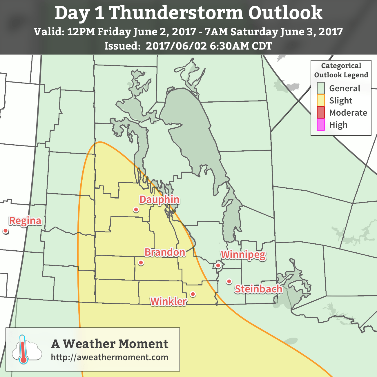
The biggest risk for severe weather will be in the afternoon during the early stages of thunderstorm development. Thunderstorms will have more energy to work with with temperatures in the 30’s combining with dew point values in the mid-teens providing 2000-2500 J/kg of CAPE. Shear will be a bit lacking, at 20-35 kt of 0-500mb bulk shear depending on the position with respect to the cold front.
That said, there’s a slight risk of severe thunderstorms across southwestern Manitoba tomorrow with the primary threat being large hail. Some of these thunderstorms may also produce strong to severe wind gusts.
The energy and dynamics to support these storms will shift as the evening progresses, with the best support slumping into the United States. As the line moves into the Red River Valley, the threat for severe weather diminishes, however thunderstorms will likely continue to roll eastwards through the night.
The Weekend
Saturday will bring clearing skies in the morning, and then a few afternoon clouds with a slight chance of another shower or thundershower in the afternoon. The showers will move down from the northwest on the backside of Friday’s low, but as of writing it seems like most guidance suggests the showers will stay to the north and pass through the Interlake. That said, there’s a chance Winnipeg may see a little more rain in the afternoon.
Aside from that, it will be a pleasant day with a high near 26°C and westerly winds to 20-30 km/h. Temperatures will dip to around 15°C on Saturday night with clearing skies.
Sunday will bring mainly sunny skies and a high temperature near 25°C to Winnipeg. Winds will be 15-25 km/h out of the north. All things considered, a great day!
Winnipeg’s seasonal daytime high is currently 22°C while the seasonal overnight low is 9°C.
I had a question about that prognosis made about models being too aggressive with dewpoint advection that day. What exactly determines how models are being too aggressive with any meteorological parameter and why would/should that solution be necessarily dismissed, unless its showing some sorta gross exaggerated value that would obviously be an outlier? How do forecasters really know if such a solution is incorrect when in fact it could be the other solution that is incorrect? When you say models were being too aggressive, it sounds like more than one model was showing this solution, so wouldn’t that give some credibility to the possibility of that solution maybe being true, instead of the other? (again unless extreme outlier values were being shown).
Great question!
Model assessment is difficult on the best of days, and one of the big challenges in the realm of weather forecasting is learning how to tell if weather models are wrong, even if all of the major ones are forecasting the same thing (which typically implies that they would be leaning towards the right answer).
In this case, it was determined that the models were being too aggressive with surface dew points based on a combination of where that level of dew point currently exists (and in this case, it was mainly in Kansas), local knowledge (crops are just beginning to grow so evapotranspiration is still low), and known biases within each of the models (e.g. the GFS used to be way to high with dew points).
In the end, it worked out fairly well. Surface dewpoints remained under 15°C until the rain moved into the region. It was interesting to see that that higher dew point air had moved in -off- the surface; as air from higher up was mixed down in the rain, the dew point rose up to 18°C (what the model was originally predicting at the surface).
Knowing whether or not that moisture will materialize at the surface before storm development is important because it can have a dramatic impact on the strength of the the thunderstorm.
That said, it’s all a bit of an art form; a combination of comparing how the model initializes things with how they actually are, some meteorological knowledge of what’s within the bounds of possibility, and a level of comfort of knowing what each model’s tendencies may be. Mash all that up, combine with experience, and sometimes you’ll get it right!