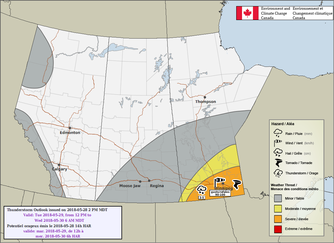
There is growing confidence that the heat and humidity expected to move into southern Manitoba on Tuesday will bring severe weather to the region. Most areas in the south will need to keep their eyes to the sky and stay alert for any watches or warnings issued by ECCC, particularly for the afternoon into the evening.
Although conditions are fairly dry now, a strong low-level jet will advect significant amounts of Gulf moisture northwards into the region overnight. This will mix down fairly quickly in the morning, resulting in a rather startling transition from yesterday’s comfortable humidity to very muggy conditions. The heat and humidity will set the stage for some explosive thunderstorm potential on Tuesday afternoon.
The focus for thunderstorm development will be a warm front that should lie close to the Trans-Canada Highway corridor by Tuesday afternoon. Storm development is a bit sensitive; in order for the storms to form, cloud cover from any overnight convection will have to clear out enough to allow temperatures to warm into the mid-twenties. Too much cloud cover or more nocturnal convection than expected? The warm front could shift south, daytime heating could be limited, or — if the nocturnal convection was vigorous enough — much of the existing mid-level instability could be consumed.
That said, guidance suggests that much of the Red River Valley and areas east should see enough sunshine to warm things up so we’re going to go ahead and assume that’s correct.
Starting with the foundations and looking at the MIST principles:
- Moisture: Significant moisture with deep-layer dew point values climbing to nearly 20°C. A well-organized southeasterly flow within the warm sector will sustain and replenish low-level moisture through the day.
- Instability: 850-500 mb lapse rates between 7 and 8°C will combine with the high dew points and temperatures in the 26-28°C range to produce 1500-2000 J/kg of MLCAPE. Lifted index values near -9 reflect the significant instability associated with this system. Capping should not be too much of an issue with a 30-40 J inversion forecast to erode in the afternoon.
- Shear: Perhaps the weakest looking aspect of the day; while the column shows favourable veering with slightly looping low-level hodographs, inflow winds will be weak. Some decent winds in the low- and upper-levels, but mid-level winds are also lacking a bit. All in all, probably enough shear to organize things, but linear shear looks stronger than the twisting, so thunderstorms will likely line out fairly quickly.
- Trigger: A prominent warm front draped across the region will provide the focus for convective initiation.
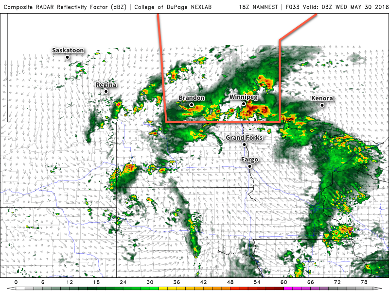
The next 24 hours looks to generally play out something like this for the Red River Valley: first, a few elevated non-severe thunderstorms will develop tonight ahead of the warm front as it lifts northwards and move through the region early Tuesday morning. They’ll clear out by mid-morning, leaving behind mixed skies. The heat and humidity will quickly build, and new thunderstorms will develop along the warm front mid-afternoon. These thunderstorms will initially develop as discrete supercells or multicellular clusters, then grow upscale into some sort of QLCS1. The primary threats from these thunderstorms will be large hail and damaging winds. Of particular concern will be the potential for a bow echo to form on the northern edge of the warm front and track eastwards along the frontal boundary, producing an extended swath of strong to severe winds.
While the possibility of a tornado cannot be completely ruled out, the relatively weak inflow winds limit it to an unlikely and isolated threat.
The thunderstorms will push northeast of the Winnipeg and the Red River Valley in the evening. The severe weather threat will likely be over by 9 or 10 PM.
Although I haven’t gone into it too much, it’s worth noting that this severe thunderstorm threat continues westwards into southwestern Manitoba. In addition to the severe weather threat, the region also faces greater risk of significant rainfall as moisture lifted up into the atmosphere by the thunderstorms runs into this system’s deformation zone, likely creating a slow-moving southwest-northeast band of showers and/or thunderstorms through the Parkland and Interlake capable of producing substantial mounts of rainfall.
This is, of course, just the best forecast we can provide at the current time. A lot of this hinges on thunderstorms developing overnight in the expected way and that can be a precarious thing to depend on. That said, it’s definitely worth keeping an eye on things tomorrow and keeping aware of any watches or warnings issued by Environment Canada.
- QLCS stand for quasi-linear convective system and denotes the general family of thunderstorms that develop along lines such as squall lines and bow echoes. ↩