Temperatures Climb Above Freezing But More Snow Ahead

Temperatures will finally climb above 0°C this week, but sadly more snow is on the way.

Winnipeg will see temperatures finally climb above the freezing mark today as the high climbs to around 0 or +1°C under sunny skies. Once the sun burns off the morning chill, it will actually be a fairly nice day with light winds as a ridge of high pressure moves across the province. A bit of cloud cover will begin moving into the region tonight as temperatures dip to a low near -7°C.

Tuesday will bring mixed to mostly cloudy skies as thicker cloud cover builds into the province ahead of the next low tracking across the Prairies. Temperatures will reach the closest to seasonal they’ve been since March 28th with a high near +4°C expected. Unfortunately, this will still be a fair amount below the seasonal high of 8°C. Winds will pick up out of the west to around 15 to 25 km/h in the afternoon. Skies will become overcast Tuesday evening with temperatures falling to a low near -4°C.

12hr. Accumulated Snowfall GDPS/GFS/NAM Comparison valid 00/06Z Thursday April 12, 2018
Comparisons of 12 hour accumulated snowfall across Southern Manitoba through the day Friday

A weak low passing through Saskatchewan into North Dakota will spread a narrow swath of snow southeastwards across the Canadian Prairies. It will spread snow across Manitoba through Wednesday, however where the snow exactly falls is a bit in question and depends precisely on the track the low ends up tacking. In general, it looks like this low will produce a swath of snow from western Manitoba into North Dakota. Around 5 to 10 cm of snow looks likely along the centre of the swath with amounts quickly tapering off into the 2 to 4 cm range to the north and south. Isolated pockets of higher amounts are possible under the heaviest band.

Winnipeg will likely end up under or just north of this band. It looks like 2 cm would be a likely low-end forecast for Winnipeg, with 3 to 6 cm looking likely through the day. That said, with temperatures near or just above freezing, some of that snow may melt, shaving a bit off the measurements.

The snow will taper off in the afternoon/evening, with winds picking up out of the north-northeast to around 20 to 30 km/h. Temperatures will head to a low near -6°C under cloudy skies on Wednesday night.

Long Range Outlook

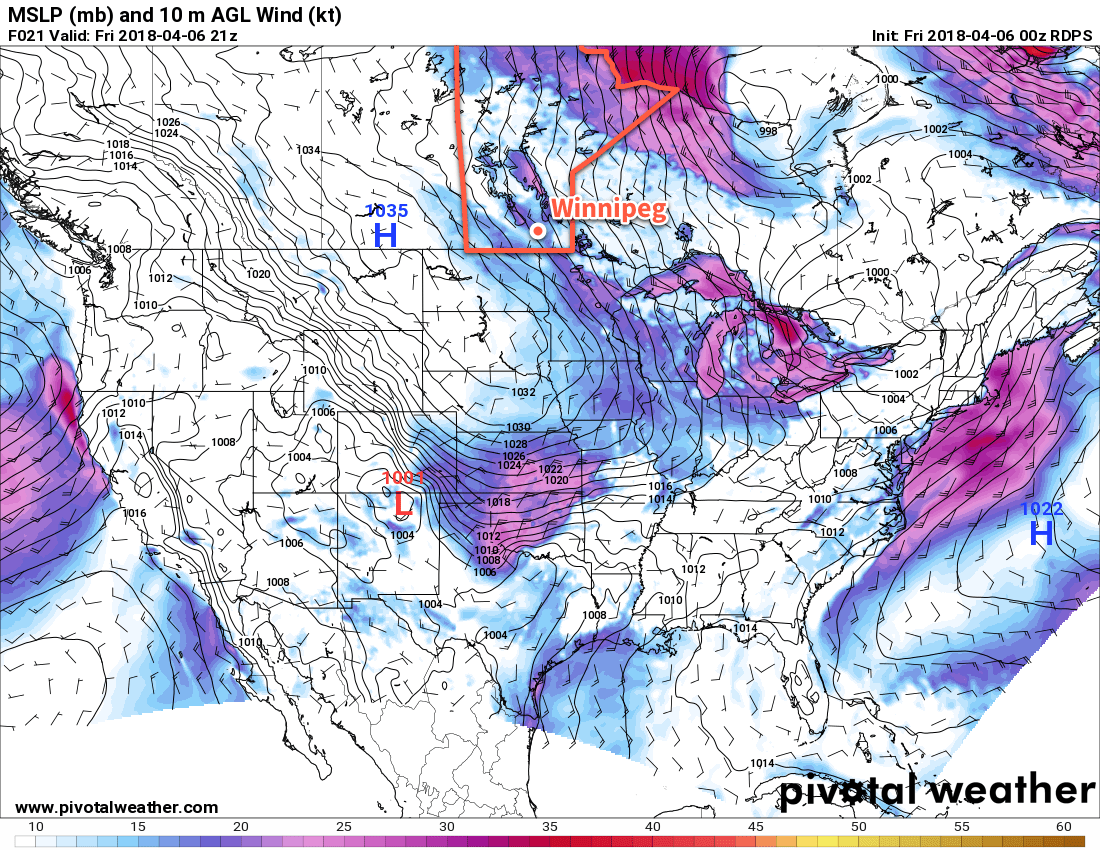
Attention then turns to Friday, where weather models are picking up on the development of a potent storm in the United States but have strongly diverging opinions on where it will go. There may be a good chance that it remains south of the border as a strong deformation zone develops south of the 49th as the cooler outflow from the northern Prairies is pinned against the developing Wyoming/Colorado low.

GDPS 24hr. Snowfall Accumulation Forecast valid 00Z Saturday April 14, 2018
While the location is uncertain, there is good agreement of Friday’s storm system producing upwards of 25 cm of snow along its heaviest swath

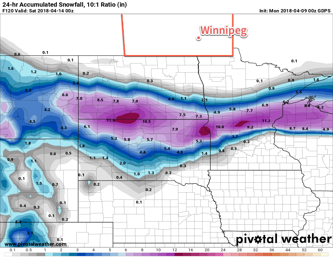
Earlier model runs had this system pushing into southern Manitoba, which is something we’ll definitely keep an eye on. It will be a very potent storm, likely producing significant snowfall with totals of more than 25 cm across its heaviest bands, so wherever it ends up will have to deal with a return of treacherous winter travel conditions. We’ll be keeping an eye on things as they develop and have updates later in the week!

Winnipeg’s seasonal daytime high is currently 8°C while the seasonal overnight low is -3°C.

Variable Cloudiness With Temperatures Inching Towards Seasonal

Winnipeg will see variable cloudiness over the coming days with temperatures inching ever so slowly back towards warmer, more seasonal values.

Today will bring increasing cloudiness to Winnipeg as a weak warm front drops southwards through the province.1 Temperatures will climb a fair amount from today’s chilly start to a high near -6°C. The northwesterly wind will be unpleasant, though, strengthening even further to 40 gusting 60 km/h. This moderate wind will create wind chill values near -25 to -30 this morning and -15 to -20 this afternoon.2 There may be a slight chance of some light flurries, but they would be unremarkable if they happen. The wind will taper off quickly this evening as skies clear and temperatures drop to a low near -17°C.

RDPS MSLP & 2m Wind Speed (kt) valid 21Z Friday April 6, 2018
Friday will bring moderate northwesterly winds to the Red River Valley as a ridge of high pressure moves in from the west

A ridge of high pressure will move over the province for Saturday and bring mainly sunny skies and light winds. Temperatures will climb to a high near -4°C, then drop down to a low near -13°C as cloud cover begins to move in on Saturday night.

Sunday will bring more cloud to the region, largely spreading across southern Manitoba from a low pressure system tracking across the Dakotas. Conditions look dry and winds will be relatively light out of the northeast. Temperatures will inch a bit warmer yet again with a high temperature around -2°C. Sunday night will bring gradual clearing to Winnipeg and the Red River Valley with temperatures falling to around -13°C.

Long Range Outlook

Next week is looking like a bit of a mixed bag. Temperatures will continue to climb towards seasonal, but the trend is still looking like slightly below-normal temperatures. Perhaps there’s some solace that daytime highs should climb above 0°C for the week. Heading into the end of the work week, the chance for precipitation ramps up with most models suggesting some rain or snow on Friday into Friday night.

Winnipeg’s seasonal daytime high is currently 7°C while the seasonal overnight low is -4°C.

  1. Yes, we’re in such a depressing weather pattern that warmer air has made it all the way from the Atlantic westwards across the Arctic and is now dropping southwards into Manitoba from Nunavut.
  2. I really don’t want to be talking about wind chill values near -30 in April…

Cool Weather Continues

The rest of the week will bring more of the same: unseasonably cold temperatures.

Cold weather will continue for Winnipeg throughout the second half of the week as a persistent northwesterly continues to tap into Arctic air. Daytime highs will remain well below the seasonal value near 6°C over the coming days starting with a high near -2°C today that will slump towards -5°C by Friday. Overnight lows will keep with the trend as well, generally hovering near -15°C, about 10°C below seasonal.

Skies will be cloudier through the second half of the week than they were in the first. A sunny start to today will lead to mixed skies this afternoon as low-level instability develops. These clouds will dissipate as soon as the temperatures begins dropping in the evening. Quickly replacing them will be a more organized area of cloud associated with a weak low pressure system tracking across northern Montana into North Dakota. This will spread mostly cloudy skies into Winnipeg and the Red River Valley for Thursday. An area of organized light snow will likely spread eastwards through areas primarily south of the Trans-Canada Highway on Thursday morning, but flurries are possible for much of the day as another cold front slump southwards through the province. Skies will be back to mixed to mainly cloudy on Friday with a very slight chance of a flurry.

GDPS 300mb Height and Wind valid 12Z Thursday April 5, 2018
An entrenched and slow-moving vortex over southern Hudson Bay is sustaining a cold northwesterly flow over the Canadian Prairies

The wind won’t be too much of an issue today, but on Thursday they’ll pick up out of the northwest again up to 30 km/h. The winds will ease on Thursday night, then pick back up to 30 gusting 50 km/h on Friday. Brrr!

Long Range Outlook

The extended forecast hasn’t changed too much from our last forecast: a slow and gradual trend towards seasonal conditions. That said, what is considered seasonal is changing quickly now; the seasonal daytime high is increasing by 0.4°C per day right now, so today’s 6°C will be nearly 9°C by this time next week. That said, it is beginning to look like temperatures may return to seasonal values by the latter half of next week, so relatively speaking, a big warm-up might be in store next week!

Winnipeg’s seasonal daytime high is currently 6°C while the seasonal overnight low is -5°C.

It’s Cold

And it’s not changing any time soon.

Spring will be decidedly absent in Winnipeg this week as a persistent northwesterly flow aloft over the eastern Prairies continues to usher cold Arctic air southwards. This is all due to a persistent vortex over Hudson Bay that refuses to budge and will remain in the area for the coming 7 days.

GDPS 500mb Height and Winds valid 18Z Monday April 2, 2018
The upper-level wind patterns will continue to usher cold air southwards into Manitoba this week.

Winnipeg will see daytime highs ranging from -10 to -4°C over the next several days, over 10°C below seasonal for this time of year. Overnight lows will be very cold tonight, dipping all the way down to -22°C thanks to the Arctic front which dropped southwards overnight. A weak warm front moving through on Tuesday1 will bring milder, but still well below-seasonal, overnight lows near -15°C for Tuesday and Wednesday night.

Skies will start out mainly sunny today, with a few more clouds moving in on Tuesday and skies becoming mixed on Wednesday.

Winds will be breezy out of the north today at 20 to 30 km/h, then taper off for the night. Winds will be a bit lighter on Tuesday out of the northwest at around 20 km/h, but then strengthen to westerly 30 gusting 50 km/h on Wednesday.

Long Range Outlook

A very gradual warming trend will continue through the remainder of the week, but temperatures are still expected to remain below-normal into next week. Daytime highs should climb back above 0°C this weekend, but will come at the cost of increasing cloud cover and a chance for rain or snow as a low pressure system moves through in the latter half of the weekend into the start of next week.

Booooo!

Winnipeg’s seasonal daytime high is currently 6°C while the seasonal overnight low is -5°C.

  1. Or rather, more like the Arctic air leaving the region.