Unsettled Friday Ushers In Transition To Cooler Conditions

Temperatures will hover at seasonal to slightly above-seasonal values until a low pressure system moves through on Friday and kicks off a major pattern change that will bring significantly cooler weather to the region.

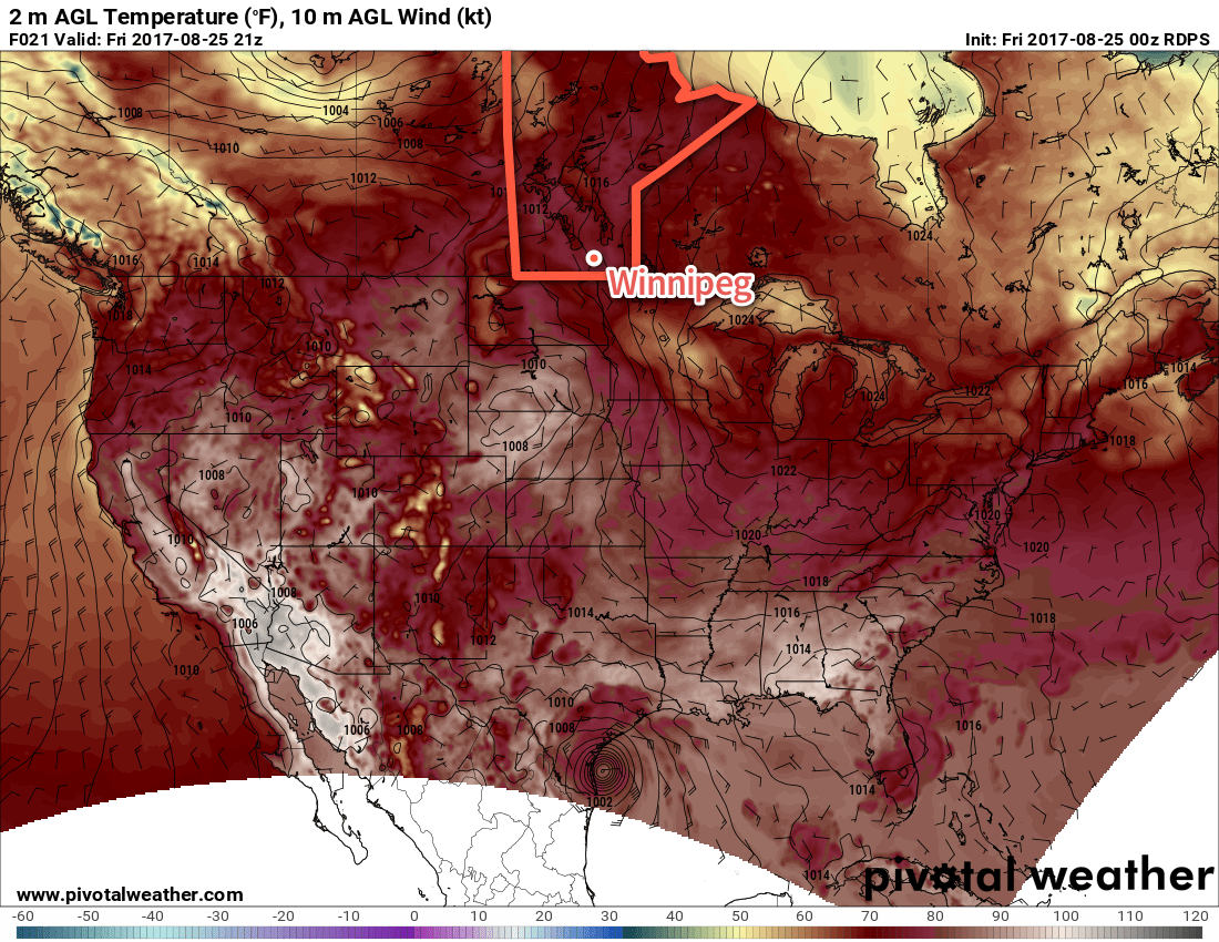
Winnipeg has a couple nice days ahead as a ridge of high pressure keeps skies fairly clear and temperatures continue slightly above normal with highs in the mid-to-upper 20’s. Winds will be light today, but pick up out of the south on Thursday to around 30-40 km/h as a trough of low pressure moves into Saskatchewan. Tonight will see a low near 12°C, but on Thursday night a combination of cloud cover moving in, continuing windy conditions, and increasing dew points will keep lows much higher at around 17°C.

RDPS 24hr. QPF valid 00Z Saturday September 2, 2017
Models indicate that much of Manitoba will see some form of rain on Friday…except for Winnipeg?

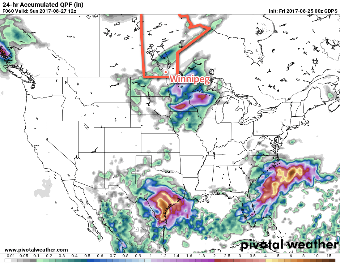
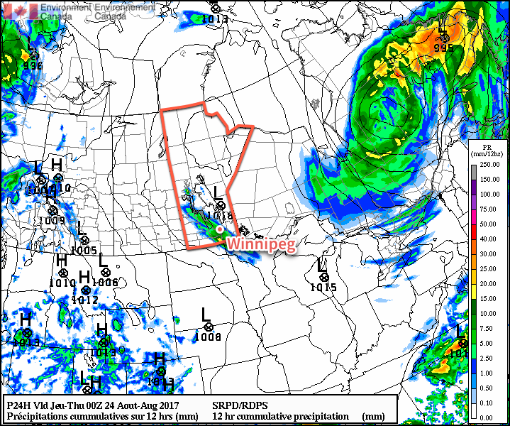
Friday’s main focus will be a low pressure system tracking eastwards through the province. At this point, it appears that it will likely develop an area of thunderstorms over Saskatchewan on Thursday afternoon, then track into Manitoba overnight. The exact placement and timing of the system has a lot of uncertainty at the moment simply due to the unpredictable nature of convection in the long-range, but in general it appears that Winnipeg will see a chance of showers or thunderstorms from fairly early in the morning until mid-afternoon or so, followed by winds shifting out of the northwest and clearing skies. It will also be a bit of a muggy day with dew points climbing into the upper teens. We’ll be able to paint a much clearer picture of this system in our next forecast post.

Long Range

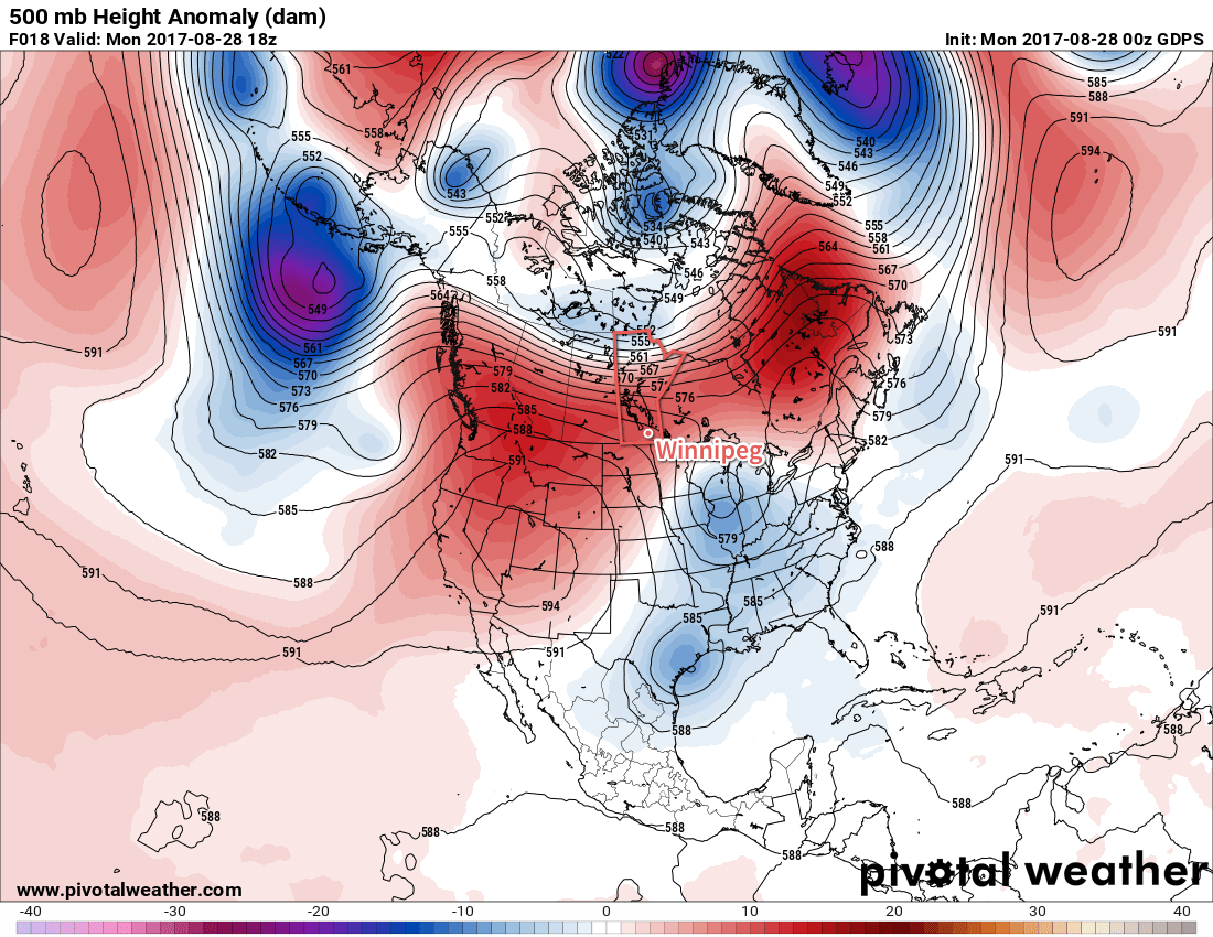
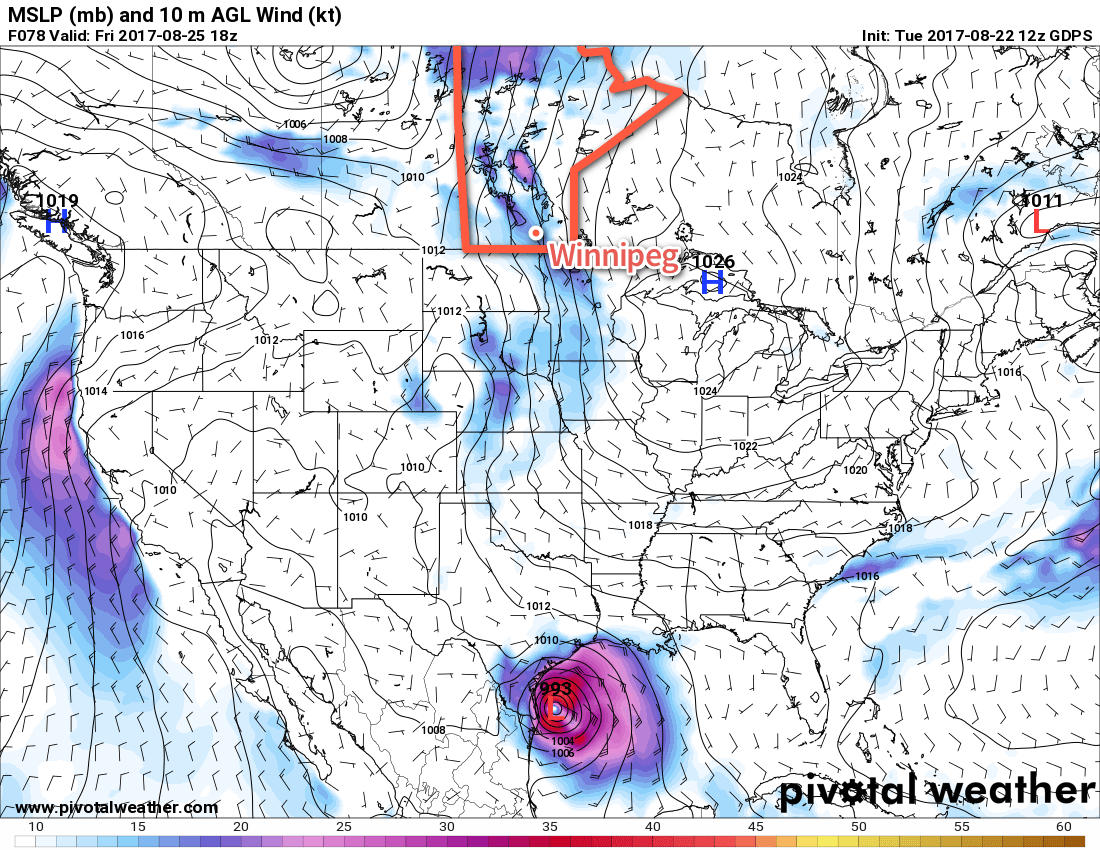
The biggest weather story for the region will be the transition that takes place behind Friday’s system. Once it moves through, the upper-level ridge over western Canada is expected to amplify quite significantly, bringing another heat wave to B.C. and portions of Alberta. The flip-side to that will be the digging of a long-wave trough over central Canada, which will bring a northwesterly flow to our region and allow much cooler air to spill southwards out of the Arctic.

GDPS Forecast 500mb Height Anomaly valid 18Z Wednesday September 6, 2017
By the middle of next week, a deep upper-level trough is expected to be in place over eastern Canada, bringing cooler conditions to Manitoba.

This could bring daytime highs as cool as 15-16°C by early next week, around 5°C below normal. This pattern would also likely bring partly cloudy to mixed skies and occasional chances for showers. It appears conditions will begin returning towards normal late next week and through the weekend.

Winnipeg’s seasonal daytime high is currently 22°C while the seasonal overnight low is 9C.

Summer Heat Makes A Return

Temperatures will continue well above-seasonal in Winnipeg and the Red River Valley for a couple more days before a cold front sweeps through, shifting conditions back to a near-seasonal pattern.

A warm front that moved across the province yesterday afternoon and overnight has brought even warmer air into the province that will send temperatures soaring to highs in the low 30’s today. Winds will remain light and morning sun will develop into partly cloudy skies this afternoon. All in all, a beautiful summer day is in store for Winnipeg & the Red River Valley. Expect temperatures to dip to a low near 17°C tonight with just a few clouds and a light south wind at around 15 km/h.

GDPS Forecast 500mb Height Anomaly valid 18Z Monday August 28, 2017
An upper-level ridge over the souther Prairies will bring warmer-than-seasonal temperatures to much of the Prairies today, shown generally by the red area.

Tuesday will see temperatures once again climb towards the 30°C mark, but highs will be a bit cooler than Monday — around 29°C in Winnipeg, but possibly in the low 30’s closer to the US border — as the warmest air is shunted out by a cold front sweeping southwards through the province. Winds in Winnipeg will shift to westerly at around 15-20 km/h midday and then to northwesterly at around 30 km/h in the afternoon as the cold front moves through. Little rain is expected with the front in Winnipeg, but east into the Whiteshell and south and southwestwards into Sprague and portions of the southern Red River Valley, some thunderstorm activity will be possible in the afternoon. The cloud will clear out for the evening as temperatures head to a low near 13°C and winds diminish.

One thing to note is that when the cold front passes through on Tuesday, it’s possible that there will be some amount of smoke that moves into the region behind it from a large fire burning in eastern Saskatchewan. By the time it reaches here it will likely be fairly diffuse, but it may be thick enough to be noticeable.

This satellite image from Sunday evening shows the large plume of smoke being generated by forest fires in Saskatchewan which will spread southwards behind a cold front on Tuesday.

Wednesday will be a pleasant day with plenty of sun, a high near 24°C and winds out of the east at 15-25 km/h. Temperatures will dip down to around 13°C on Wednesday night.

Long Range

The remainder of the work week looks quite nice with highs in the 25 to 28°C range. Thursday will bring sunny skies, but with an increasing southerly wind ahead of the next low pressure system crossing the Prairies. Friday will bring continued breezy southerly winds, more cloud, and the potential for showers or thunderstorms as the low crosses the province. Winds shift to the northwest for Friday night and then after scattered showers on Saturday, several days of below-seasonal temperatures look to move into the region.

Winnipeg’s seasonal daytime high is currently 23°C while the seasonal overnight low is 10°C.

Conditions Improve Through The Weekend

A return to summer conditions is on tap for Winnipeg as an upper-level ridge builds in behind a low pressure system that will move through on Saturday.

After a distinctly fall-like morning on Thursday where temperatures dipped as low as 3.1°C at the Winnipeg Airport, many will be relieved to hear that summer is on the way back to the region as the ridge of high pressure that brought the cold weather pushes off to the east and warmer conditions being working in from the west.

The first push of warmer weather will begin working into the region today as a slow-moving trough moves eastwards across Saskatchewan. Skies will remain fairly sunny today, but winds will pick up out of the southeast to around 30 km/h as the temperature climbs to a high near 26°C. Clouds will begin working into the region on Friday evening as the winds ease and temperatures drop towards a low near 15°C.

Temperatures will climb to slightly above-seasonal values across Southern Manitoba today.

Saturday will bring mainly cloudy conditions to Winnipeg as the broad trough of low pressure moves through the region. At the moment it looks unlikely that Winnipeg will see much in the way of precipitation, but if there is going to be any rain it would likely be in the afternoon or evening as the trough line swings through. The odds seem low, though, as the main areas of support for rain will pass by to the north and south, leaving Winnipeg & the Red River Valley in a bit of a gap. The cloudy skies will keep temperatures slightly cooler than Friday with highs near 23°C. Skies will clear out on Saturday night with temperatures dipping to a low near 14°C.

Winnipeg may dodge all of the rain moving through the region on Saturday as one feature passes to the south and another to the north.

Summer weather returns to Winnipeg for Sunday! There may be some low cloud or fog early in the morning, but that should burn off fairly quickly leaving the region with mainly sunny skies. Temperatures will be warm with highs reaching around the 28°C mark in the Red River Valley. Expect a low near 15°C on Sunday night.

Long Range

Next week will start off quite warm with highs in the upper 20’s and then trend towards more seasonal temperatures midweek. Things look to turn slightly more unsettled near the end of the week with rain and thunderstorms possible.

Winnipeg’s seasonal daytime high is currently 23°C while the seasonal overnight low is 10°C.

Another Cool, Showery Day Before A Slow Warm-Up

A shortwave rolling across southern Manitoba today will bring cloudy skies, cool temperatures, and a good chance of more rain showers through the afternoon. The remainder of the week will bring more sunshine and a slow return towards seasonal temperatures.

Extensive cloud moved into southern Manitoba overnight and will persist for much of today as an upper-level disturbance called a shortwave moves through the region. As it swings through, it will likely be supporting an area of showers that will move into the Red River Valley later this morning and move out mid- to late-afternoon. Rainfall amounts will generally fall in the 5-10 mm range throughout the main area of rain in the Red River Valley, however a narrow line of 10-20 mm accumulations may set up somewhere along the path of the shortwave as it moves through the valley.

RDPS 12hr. QPF valid 00Z Wednesday August 23, 2017
An area of showers will produce accumulating rain across a swath of Southern Manitoba today.

The cloud and rain will make for quite a cool day with high temperatures climbing to only the upper teens. Winds will be easterly wind at just 10-20 km/h. The rain and cloud will clear out this evening as a ridge of high pressure moves into southern Manitoba.

Thursday will be a relatively pleasant day when compared to Wednesday; expect mainly sunny skies, winds out of the southeast at 15-25 km/h, and a high near 23°C. Thursday night will continue clear with a low near 12°C.

Friday will bring seasonal temperatures back to the Red River Valley, but a developing low pressure system over the western Prairies will produce gusty southerly winds over the Red River Valley. The day will start off sunny, but become partly cloudy midday with winds increasing to 30-40 km/h out of the south. Highs will be near- to slightly above-seasonal in the mid-20’s.

GDPS 10m Wind Forecast valid 21Z Friday August 25, 2017
An area of breezy southeasterly winds will develop on Friday from Lake Manitoba southeastwards across the Red River Valley into Northern Minnesota.

More cloud cover will move in later in the day as a trough approaches from Saskatchewan. Expect a low in Winnipeg near 15°C on Friday night with winds gradually diminishing.

Long Range

Saturday will bring a cloudy day to the Red River Valley as a trough swings through the region. There will be a slight chance of showers or thundershowers as it moves through. There may be a few sunny breaks late in the day, but expect cloudy skies to return Saturday night with another slight chance of showers or thunderstorms.

Sunday will see things gradually improve with near-seasonal temperatures returning alongside some sunshine. The start to next week looks to bring near to slightly above-seasonal temperatures to Winnipeg with a fair amount of sunshine.

Winnipeg’s seasonal daytime high is currently 24°C while the seasonal overnight low is 11°C.