Weather Forecasts, Facts and News for Winnipeg & Southern Manitoba
Author: Brad
Brad lives in Winnipeg with his wife and two children and is the founder of A Weather Moment. He has loved weather from a very young age and has followed that passion through his life so far. He received a B.Sc. in Earth Sciences with Specialization in Atmospheric Sciences and is currently employed in the field of meteorology. You can find the author as WeatherInThePeg on Mastodon.
The weekend will bring a mixed bag to Winnipeg with temperatures climbing into above-seasonal values, but a fair amount of cloud will remain in place over the next few days, dampening the spring-like feeling.
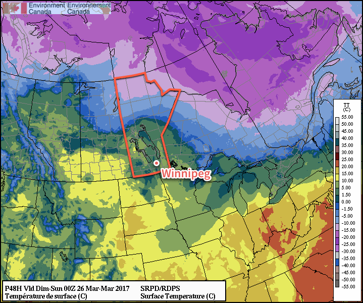
Cooler temperatures will be in place over the Red River Valley today as a result of northerly winds to 20-30 km/h that moved in behind a cold frontal passage overnight. Temperatures are expected to reach high near +2°C in Winnipeg today as those winds diminish by midday. Skies will become a mix in the morning and remain that way through much of the remainder of the day.
Skies should clear up tonight as temperatures drop to a low near -5°C.
Milder temperatures are expected across southern Manitoba on Saturday.
Saturday will bring slightly milder temperatures to the region, but alongside the warmth will come breezy southerly winds to around 30 gusting 50 km/h. Temperatures will climb to a high near 4 or 5°C with skies clouding over. Saturday night will bring diminishing winds, cloudy skies and a seasonally mild overnight low near 0°C.
Sunday will be similar temperature-wise to Saturday with a high temperature near 5°C, but a trough of low pressure moving into the Red River Valley will bring lighter winds and the chance for some rain showers. Skies will clear a bit overnight as temperatures head to a low near 0°C once again.
Long Range
As mentioned in our last post, the forecast for a continued trend of gradual warming continues. Little has changed from our outlook earlier in the week, with above-normal temperatures expected in most places over the coming couple weeks.
Winnipeg’s seasonal daytime high is currently 2°C while the seasonal overnight low is -8°C.
The wind will be back today, but this time rather than slamming colder temperatures southwards through the Red River Valley, it will be gradually bringing warmer weather back to the region. A generally warm and dry pattern will establish itself for the coming week or so, likely bringing a gradual spring melt to the Red River Valley.
As warmer weather once again moves into the Red River Valley today, like clockwork those southerly winds will ramp up and become the main weather feature of the day. The winds will increase through the morning to 30-40 km/h by midday, and then further strengthen in the afternoon to 40 gusting 60 km/h.1 These strong winds will likely persist much of the night before dropping off on Thursday morning. While all this happens, Winnipeg & the Red River Valley will see a sunny morning give way to cloudy skies midday into the early afternoon as temperatures climb to a high near -1°C late in the day.
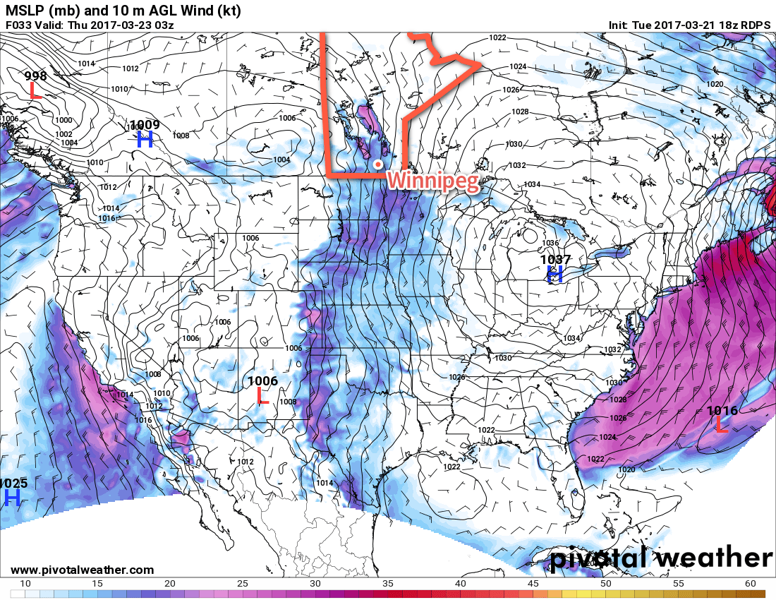
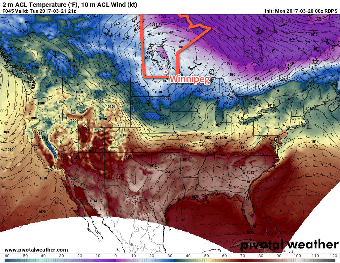
A deep southerly flow extending from southern Manitoba all the way to Texas will develop by Friday evening.
The cloudy skies will continue overnight with a slight chance of some light snow2 as a warm front associated with a low pressure system passing across the central Prairies moves through. Temperatures will remain steady near -2°C.
Thursday will bring the spring warmth as we enter the warm sector of the system passing by to the north. Temperatures will climb above normal for much of the Red River Valley with high temperatures the +5 to +7°C range. The winds will ease off in the morning and we’ll be left with mixed to cloudy skies. A weak cold front will slump through late in the day, but have little effect on temperatures overall; Thursday night will see a low of just -3°C or so under fairly cloudy skies.
Friday will see temperatures return to near-seasonal values with a high near +2°C under partly cloudy to mixed skies. The lack of any notable winds will make it a pleasant day. Lows will drop to around -3°C on Friday night.
Long Range
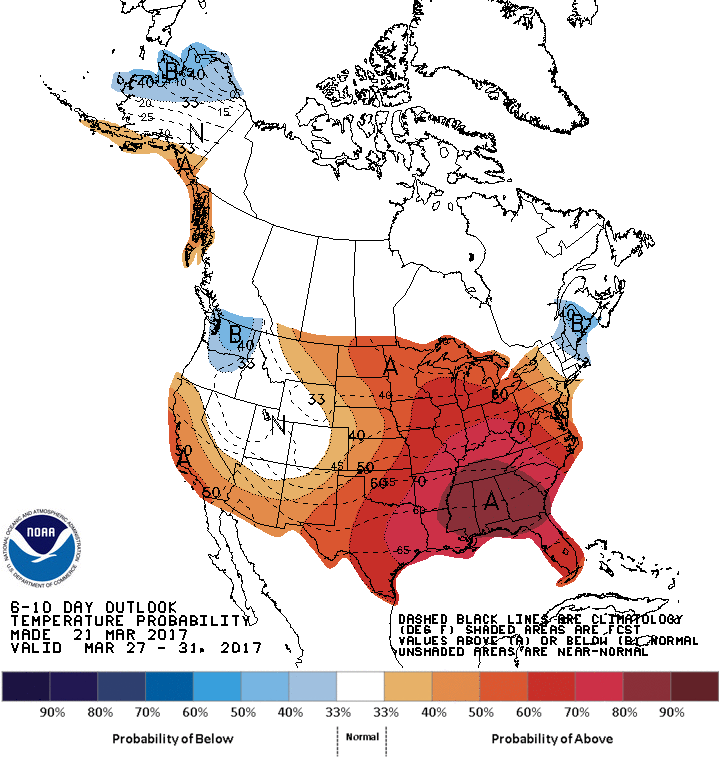
The long range forecast is definitely pointing towards the arrival of spring not just for southern Manitoba, but a vast amount of North America. A stable long-wave pattern will be developing over the southern Prairies for the coming 1-2 weeks, bringing relatively dry conditions and ample warm air.
CPC 6-10 Day Temperature Anomaly Forecast — Valid March 27-31, 2017
Daytime highs will climb into the mid- to upper-single digits this weekend and remain there for much, if not all, of the coming week. Throughout this period, it looks like the potential for rain across the Red River Valley is fairly low. Some models hint at a chance for some light rain or snow on Sunday night, but otherwise keep things fairly dry.
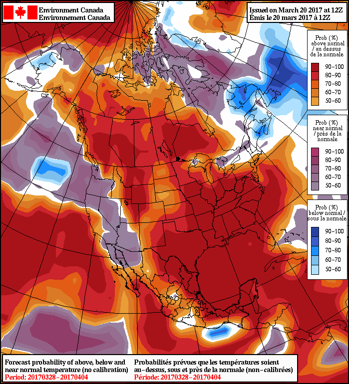
NAEFS 8-14 Day Temperature Anomaly Forecast — Valid March 28 to April 4, 2017
Overall, even into the Week 2 timeframe, temperatures look to remain above normal…nearly everywhere. It’s practically a certainty that we’ll be seeing the elimination of the snowpack across the Red River Valley in the coming days, and a substantial melting, if not elimination, of the substantial snowpack over southwestern Manitoba and southeastern Saskatchewan that was produced by the major blizzard last week.
All is not fun and games, though, as the melt, particularly in drainage channels to the Assiniboine river, will transition the region towards dealing with flooding concerns. Fortunately, much of the snowpack has already been eliminated in the North Dakota Red River Valley, which will help ease things slightly. Spring flood forecasts are the responsibility of the Manitoba Government. News and updates can be found here.
Winnipeg’s seasonal daytime high is currently 1°C while the seasonal overnight low is -9°C.
There’s a very slight chance they may even reach up to 50 gusting 70 km/h. ↩
No accumulations are expected with any snow that does materialize for Winnipeg & the Red River Valley. ↩
A cold front passing through the region this evening will bring the chance for some flurries this evening and return temperatures well below seasonal…for one day. Milder weather quickly returns for the remainder of the week on Wednesday.
Today will be a fairly sunny day with the Red River Valley still in the warm-sector of a major low pressure system bringing blizzard conditions to portions of northern Manitoba. Temperatures will be mild with daytime highs generally around the 4-6°C, bolstered by westerly winds at 20-30 km/h.
Things will change this evening when a cold front sweeps through the Red River Valley, bringing a chance of flurries and gusty northwesterly winds to 30-40 km/h. Temperatures will drop to around -5°C within a few hours, and then continue on to an overnight low near -13°C. Winds should taper off to around 20 km/h by midnight and remain there for the rest of the night. Skies will clear out fairly quickly behind the front.
Tuesday will see a large ridge of high pressure build into the region, bringing mainly sunny skies and winds that gradually taper off. Temperatures will be cool with daytime highs near -7°C. The northerly winds will taper off in the afternoon and then temperatures will head down to a low near -14°C overnight.
An Arctic ridge will be in place over Manitoba on Tuesday, bringing below-seasonal temperatures.
Wednesday will start off cool, but warm up through the day as a southerly wind to 30-40 km/h develops ahead of an approaching low pressure system. Daytime highs across the Red River Valley will be near 0°C as cloudy skies develop later in the afternoon. With windy conditions and warm air continuing to push eastwards overnight, temperatures will remain mild with lows near -2 to -4°C on Wednesday night. As the warm front moves through, there will be a chance for some precipitation, which could end up as anything from rain to snow or freezing rain.
Long Range
The remainder of the week looks mild with daytime highs above 0°C and generally settled conditions.
Winnipeg’s seasonal daytime high is currently 1°C while the seasonal overnight low is -10°C.
Today will be categorically unpleasant as a brisk northwesterly wind ushers colder air into Winnipeg & the Red River Valley behind a cold front that passed through earlier this morning. It will be relatively short-lived, though, as temperatures begin rebounding immediately on Saturday and climb back above-normal for Sunday.
A cold northwesterly wind will be in place over Winnipeg & the Red River Valley today, starting out at around 30km/h but strengthening to 50 gusting 70 km/h midday. This will be accompanied by light snow, with anywhere from 1-3 cm looking like the most likely accumulation. The combination of yesterday’s rain, freezing overnight, and the gusty winds with snow will likely make highways in the Red River Valley slippery, so you should be sure to give yourself extra time and take caution if you have to travel today. Additionally, if any slightly heavier snow bands develop, visibilities will likely be very reduced as the strong winds blow the snow around underneath them. Temperatures will slowly drop through the day to around -4°C by this evening.
Winds will ease off through the night with clearing skies as temperatures dip to a low near -13°C.
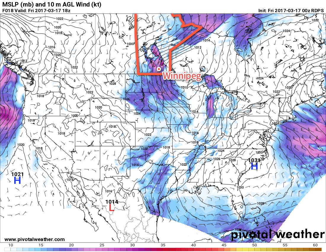
Moderate northwesterly winds (pink) will be in place over the Red River Valley today.
Saturday will be cool with a high of just -3 or -2°C and increasing cloud. Winds will increase to around 15-20km/h by the end of the day, and then continue to strengthen overnight to 30-40 km/h. Temperatures will remain steady near -2°C overnight under cloudy skies. There’s a very slight chance of some light flurries early Sunday morning.
Sunday will be a pleasant day with temperatures climbing to a high near +3°C under mixed skies. Winds will shift from southerly at 15-20 km/h to westerly at around 30 km/h late in the afternoon. Expect a low near -2°C under partly cloudy skies on Sunday night.
Long Range
Looking ahead into next week, it appears a cool-down is on the way Monday as northwesterly winds usher in an Arctic ridge behind the low pressure system tracking across the northern Prairies. This will send daytime highs back down to the freezing mark or just below for the first half of the week. Warmer weather returns in a windy southerly flow in the second half of the week, but along with it comes a couple potential disturbances that could bring precipitation to the Red River Valley.
Winnipeg’s seasonal daytime high is currently 0°C while the seasonal overnight low is -11°C.