The Heat Is On; Thunderstorms Possible Saturday

While July has been relatively pleasant, temperatures have [somewhat surprisingly] been largely below seasonal for much of the month. That’s all about to change as significant heat builds across the region to round out the month.

A developing southerly wind of 20-30 km/h this morning will draw warmer air northwards out of the United States and help push daytime highs up to around the 30°C mark. Skies will remain mainly sunny and humidity in the mid-teens should keep things feeling relatively comfortable. Expect lows to fall to around the 19°C mark tonight with winds continuing out of the south and partly cloudy skies.

An upper ridge in place over Southern Manitoba today will bring warm temperatures to the region.

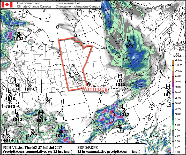
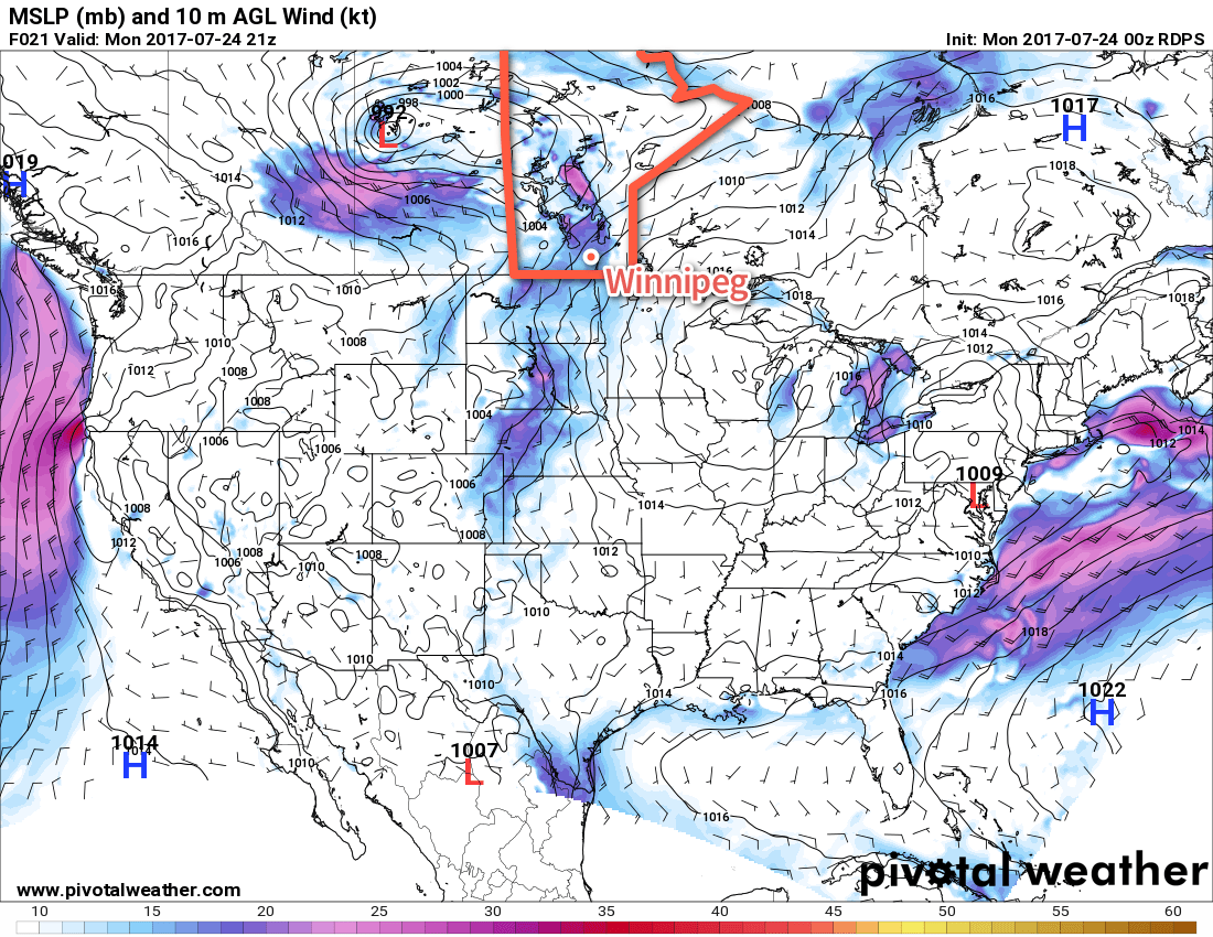
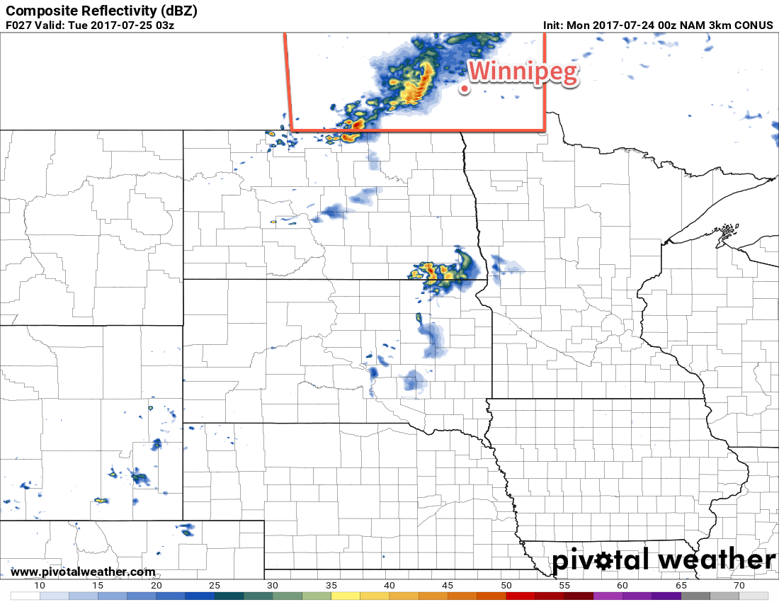
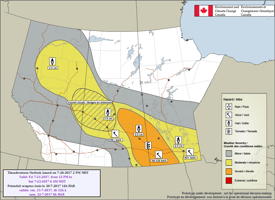
Saturday will see a cold front slowly sweeping across the province, bringing with it a severe thunderstorm risk. Before that, though, there will be a hot summer day on tap with highs once again near the 30°C mark under mixed skies. With the southerly winds slowly diminishing and dew points rising to around 19 or 20°C, it will end up feeling quite humid in the afternoon. The cold front will progress eastwards through the day, reaching the Red River Valley mid- to late-afternoon. As it pushes into the valley, it will bring with it the risk of severe thunderstorms.

Going over the MIST ingredients:

  • Moisture: Low-level moisture will be plentiful with surface dew points climbing towards the 20°C mark and with deep moisture extending towards 850 mb.
  • Instability: Slight to moderate instability will be in place. Mid-level lapse rates leave a bit to be desired with expected values only around 6-7°C/km, but this is somewhat offset by the substantial latent heat available through surface moisture. Depending on the exact orientation of this system, the heights may be rising as the front stalls, which would work against thunderstorm development.
  • Shear: Bulk shear values around 25-30 kt will be in place which is on the lower end of values. Low-level shear will likely be weak and mid-level shear largely unidirectional.
  • Trigger: The cold front will slowly slump southeastwards, gradually slowing into the evening hours.

The primary threats with any storms that develop will be large hail and damaging winds, although with dew points so high, torrential rain is likely as well. They would move southeastwards through the Red River Valley. The biggest question will be whether or not storms actually develop. The threat will exist generally around the Trans-Canada Highway corridor and south, but we’ll provide an update on Saturday with a new look at the day’s potential.

A cold front will be in place across Southern Manitoba on Saturday afternoon.

The thunderstorm threat will diminish before midnight and temperatures will then drop to a low near 17°C under clearing skies.

Sunday will be another hot day with a high near 31°C but more comfortable humidity as the dew point drops back towards the mid-teens. Skies will be partly cloudy and winds will be light out of the east. Winds will shift out of the south on Sunday night and increase to 15-25 km/h, keeping temperatures fairly warm; the overnight low will be just around 19 or 20°C.

Long Range

Temperatures will continue to be warm through the start of next week with partly cloudy skies and highs generally around the 30°C mark. Monday will likely be moderately humid again, but things will dry out on Tuesday as a cold front moves through. The rest of the week looks fairly quiet with near-seasonal temperatures and low humidity.

Get The Sunscreen Out; Plenty of Summer Sun & Heat On The Way

A beautiful second half to the week is ahead for Winnipeg as an upper-level ridge building into the Prairies brings plenty of sun and warmth to the area!

It’s been a while, but the forecast today is finally short once again. The next few days will be great across Winnipeg and the Red River Valley as upper-level ridging clears skies and ushers warmer weather back into the region. Today will bring highs near 26°C to Winnipeg and area with mainly sunny skies until late in the afternoon. A very weak upper-trough moving through late in the day will bring a few clouds to the region and perhaps trigger an isolated evening shower, but the main chance will be north of the city and it’s not expected that Winnipeg or areas south have much of a chance of seeing any rain.

The RDPS shows some isolated showers, mainly through the Interlake, late today in to the evening.

Temperatures will head to a low near 16°C tonight. Thursday and Friday will both be mild with high temperatures climbing towards 30°C on Friday. Both days will have plenty of sun; Thursday should bring nothing but sunshine while Friday brings partly cloudy skies. Winds will be out of the northwest today at 15-25 km/h, light on Thursday, and then increase out of the south on Friday to 20-30 km/h. Temperatures will dip down to around 17°C on Thursday night, but Friday will see a warmer overnight low near 20°C.

Long Range

Warm weather will continue throughout the weekend. A low pressure system moving through the Prairies on Saturday will bring increasing humidity and a risk of thunderstorms to much of Manitoba. For Winnipeg and the Red River Valley, the risk for storms will likely be in the late-afternoon and evening. Sunday will see northerly winds usher in drier air while temperatures return to near-seasonal values.

Next week looks to bring near-seasonal temperatures with a slight chance of some thunderstorms on Tuesday and Wednesday.

Winnipeg’s seasonal daytime high is currently 26°C while the seasonal overnight low is 13°C.

Warm With A Chance of Thunderstorms, Then Turning Drier

The weather returns to slightly warmer than normal summer fare for Winnipeg to start the week with highs in the upper 20’s and mild lows. It will also be relatively dry, with the only significant chance for rain coming on Monday night as a cold front slowly moves through the Red River Valley.

Today will be a warm and windy day in Winnipeg as breezy southerlies bring summer heat and slightly muggy conditions to the Red River Valley. Skies will become mixed fairly early in the morning as the south-to-southeasterly winds ramp up to 30-40 km/h. These gusty southerly winds will bring mild temperatures into the region, pushing daytime highs just short of 30°C. In addition to the warmth, these winds will maintain the slightly humid conditions in place with dew points remaining in the 16-18°C range. Closer to the cold front — primarily over the southwestern corner of the province but also possibly into the western Red River Valley — moisture will pool and dew points will likely rise into the low 20’s, making for quite a muggy day in those areas.

A potent low pressure system over western Saskatchewan will spread gusty southerly winds across the Red River Valley on Monday afternoon.

By evening, a cold front will be pushing eastwards into the Red River Valley, bringing with it a chance of showers or thunderstorms to much of southern Manitoba.

Going over the MIST ingredients:

  • Moisture: Dew points will climb generally into the mid-teens, but elevated moisture is expected near the cold front as moderate southerly winds enhance moisture pooling ahead of the front. Moisture is also expected to be moderately deep, extending to roughly 850 mb.
  • Instability: Moderate mid-level lapse rates on the order of 7-8°C/km will combine with the low-level moisture to produce MLCAPE values of 1500-2000 J/kg.
  • Shear: Shear will be somewhat lacking with only 25-30 kt of 0-6 km bulk shear; this is fairly low and may be the real limiting factor in any thunderstorm activity that may develop.
  • Trigger: A pronounced cold frontal trough moving eastwards will provide the focus for any convective development.

Overall it seems that there will be enough energy available for severe thunderstorms, but the lack of shear will throw a wrench into the certainty of a large-scale severe weather outbreak.

The highest risk for severe weather in southern Manitoba will be over the southwestern corner where scattered thunderstorms first fire up along the cold front. These storms will have the potential to produce significant hail and strong winds. While an isolated tornado is possible, it won’t be an elevated threat with today’s thunderstorms. As the cold front moves eastwards through the evening and spreads the thunderstorm threat into the Red River Valley, the threat shifts towards favouring strong winds. Temperatures will bottom out overnight around 18-19°C with the winds tapering off.

This simulated RADAR image from the 3km NAM model shows a forecast of thunderstorms for the Red River Valley on Monday evening.

The weather then settles for Tuesday and Wednesday as a broad ridge of high pressure builds into the Prairies. Skies will clear and remain mainly sunny for much of Tuesday and Wednesday as temperatures climb to highs near 27°C both days. It will remain slightly humid with dew points remaining in the mid-teens through the middle of the week. With that humidity remaining in the region, it will keep overnight lows in the mid-teens as well.

Long Range

Gradual upper-level ridging will build into the Prairies late this week and into early next week, bringing continued mild weather and low probabilities of rain. The odd system may slide across southern Manitoba from the northwest, returning temperatures back to seasonal alongside a chance of showers. Overall, though, it appears Winnipeg and the Red River Valley will be entering into a fairly dry pattern.

Winnipeg’s seasonal daytime high is currently 26°C while the seasonal overnight low is 13°C.

One More Chance of Severe Thunderstorms, Then Gradually Settling

A threat of severe thunderstorms will develop across much of Southern Manitoba today as a low pressure system pushes eastwards out of Saskatchewan, however there are several potential hiccups that introduce some uncertainty to where the thunderstorms will actually end up developing. Moving into the weekend, temperatures will cool with highs near to slightly below seasonal and the unsettled weather will slowly improve.

Today is…complex. A huge number of variables are at play, all of which can impact the outcome of today with even small changes, and it’s important to state up front that this is being written on Thursday evening and that how thunderstorms develop overnight will have the potential to make a large impact on Friday’s weather.

With that out of the way: there’s a potential for significant thunderstorm activity later today across much of southern Manitoba. But first, this morning. To start the day, there may be some isolated to scattered thunderstorm activity across southern Manitoba that developed overnight. Any activity still going should weaken and diminish through the first half of the morning. Once that’s out of the way, Winnipeg & the RRV should see mixed skies with temperatures climbing up to a high near 27°C and east to southeasterly winds at 15-25 km/h.

Just one guess at what may happen today: perhaps a line of strong thunderstorms already near the Manitoba border in the early afternoon?

Severe thunderstorms are very likely in eastern Saskatchewan this afternoon, triggering along a warm front that is slowly sliding eastwards. These thunderstorms will push eastwards into southern Manitoba in the early evening, and then continue into the overnight hours. Near the Saskatchewan border, these thunderstorms will have a good chance of producing all manner of severe weather associated with thunderstorms: torrential rain, large hail, damaging winds, and/or a tornado. If they haven’t by the time they move into Manitoba, these thunderstorms will then quickly develop into a line of thunderstorms pushing eastwards and transition towards a primary threat of large hail and strong winds. There is the potential for this line of thunderstorms to develop bow echoes which are segments of the line that accelerate eastwards more quickly than the rest of the line as strong straight-line winds punch through them. It’s important to note that bow echoes can produce damage on par with weak tornadoes, so they can pose a danger to property.

Environment Canada’s thunderstorm outlook for today from yesterday afternoon sums up the severe weather potential well for Manitoba this evening.

The biggest question is what the extent of this line will be and exactly where it ends up. Some models suggest that the line will move through Parkland Manitoba & the Interlake with a gap through the Trans-Canada corridor and then a second set of storms further south, while others plow the line straight down the Trans-Canada Highway and through Winnipeg and the Red River Valley. The simple reality is that with highly dynamic setups like this, the best we can do is be aware of the hazard potential — primarily large hail and strong winds in the Red River Valley — and then monitor things as they develop and see where that hazard will end up being realized. We’ll be keeping an eye on things and sharing updates on social media, so be sure to give us a follow on Facebook or Twitter if you’d like to stay up to date!

Saturday will be dominated by a cold upper-level low moving through the region. This will keep temperatures a bit cooler than seasonal as breezy northwesterly winds move into the region. There will be a fairly good chance of some showers or thunderstorms in Winnipeg and the Red River Valley by late-morning and through the afternoon. No organized severe weather threat will exist, but some marginally severe hail1 may be possible. Additionally, with the cold upper low moving through, funnel clouds will be possible, although that looks more likely to the north and northeast of Winnipeg. Everything will settle down on Saturday night with clearing skies as temperatures dip to a low near 13°C.

A cold low over Manitoba on Saturday – seen by the dark green colouring around Winnipeg – will trigger showers and thunderstorms.

And finally, a quiet and calm Sunday is in store for Winnipeg with clear skies and a near-seasonal high around 25°C. Expect temperatures to drop into the mid-teens on Sunday night.

Long Range

Next week looks quieter with the only weather system of note moving through on Monday night, potentially bringing some scattered showers or thunderstorms to the region. Otherwise we expect near-seasonal temperatures for the remainder of the week with a fair amount of sunshine.

Winnipeg’s seasonal daytime high is currently 26°C while the seasonal overnight low is 13°C.


  1. Environment & Climate Change Canada defines severe hail as hail with diameter of 20 mm or more.