Weather Forecasts, Facts and News for Winnipeg & Southern Manitoba
Author: Brad
Brad lives in Winnipeg with his wife and two children and is the founder of A Weather Moment. He has loved weather from a very young age and has followed that passion through his life so far. He received a B.Sc. in Earth Sciences with Specialization in Atmospheric Sciences and is currently employed in the field of meteorology. You can find the author as WeatherInThePeg on Mastodon.
Unsettled weather will continue through the weekend as multiple disturbances ripple across Southern Manitoba, bringing mixed skies alongside a few chances for rain.
Yet another round of nocturnal convection1 will roll through this morning just ahead of a weak cold front slowly pushing eastwards across the Red River Valley. As of writing this2 there is still some uncertainty as to how extensive the convection will become, but best indications are that we could see a few showers or thundershowers early this morning as a more intense area of convection passes to the south. After that, Winnipeg & the Red River Valley should see clearing skies through the morning, especially once the "cold" front moves through.
Behind the cold front, westerly winds will ease the humidity that has built into the region over the past two days as dew points drop from the upper teens back towards the 10°C mark. With drier weather and sunny skies, temperatures should climb to a high near 27 or 28°C throughout the Red River Valley with winds up to 20-30km/h out of the west-northwest. Expect partly cloudy skies overnight with a low near 15°C.
Saturday will bring more cloud to the region as mixed skies develop through the morning with a chance of some light shower activity through the Red River Valley. Things should clear out by the evening, and the late day sun should push us to a high near 26°C.
While models keep the bulk of precipitation to our south on Saturday, a few light showers are possible thorugh the Red River Valley.
Winds will shift back around to the south late in the day, beginning to bring more humid air back into the region; with dew points expected to rise back into the mid-teens overnight, overnight lows will be kept fairly warm at around 17°C. We'll see a few clouds overnight.
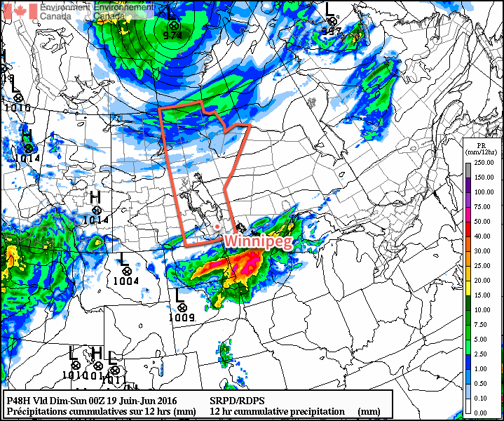
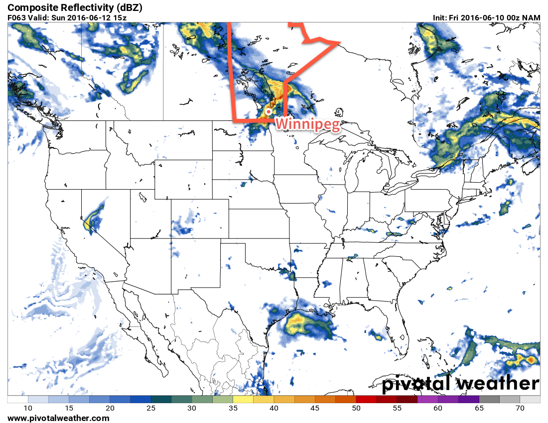
Sunday will see yet another disturbance move through the region bringing another chance of showers or thunderstorms. The main threat for precipitation will occur through the morning hours, followed by skies becoming mixed in the afternoon. Daytime highs should be around 26 or 27°C with muggy conditions in place much of the day as dew point values hover around 17°C. As skies clear, gusty winds will pick up out of the west to around 30 km/h.
This simulated RADAR image from the NAM shows a large area of convective rainfall moving through the Red River Valley on Sunday.
Drier air will push in Sunday evening, helping overnight lows dip to a cooler 13°C or so with just a few clouds.
Long Range
Unfortunately, things don't look much better to start off next week. Another round of showers are possible late Monday through the overnight period as a disturbance slumps through from the northwest. Afterwards, though, it looks like we might see a few dry days with daytime highs ranging from the low 20's to the upper 20's.
Nocturnal convection is the term applied to thunderstorms that persist through the overnight period. They are different from typical thunderstorms in that they get their heat and moisture from features detached from the ground. ↩
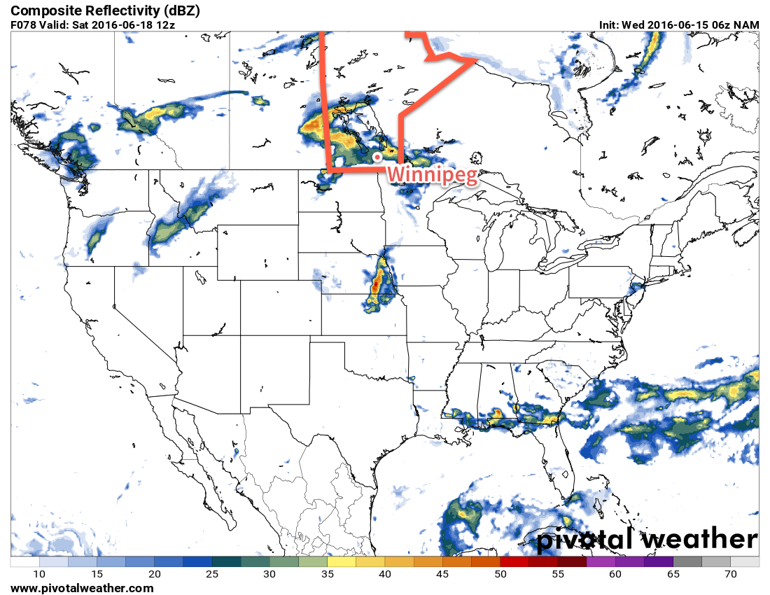
Conditions will be mixed across Winnipeg & the Red River Valley through the remainder of the week with today's wet weather & seasonal temperatures giving way to warmer conditions with unsettled conditions building back in for the end of the week.
Today will start off with showers across the southern Red River Valley; there's a chance that we'll see some of the activity here in Winnipeg, but so far this system has been very difficult to get a handle on. Winnipeg may see the precipitation edge into the city this morning, but there's about an equal chance that it will stall just to the east of the city and never make it in.
An area of rain is pushing towards Winnipeg this morning.
By this afternoon, the rain should head back off towards Ontario and Winnipeg will be left with cloudy skies that will clear through the afternoon. Temperatures will climb towards a high of 23°C in Winnipeg today, with highs of 22-25°C across the Red River Valley. Expect a low near 15°C tonight under mainly clear skies.
Thursday will be a very nice day through the Red River Valley with a few clouds and much warmer weather. Daytime highs will climb around 28°C while a breezy south-to-southeasterly tap into higher moisture to the south, pushing dew points into the upper teens. This will make things feel slightly muggy, and that high of 28 feel closer to something in the mid-30's. A frontal wave passing through in the late afternoon will bring a risk of thunderstorms to Winnipeg & the Red River Valley through the evening hours. Temperatures will fall towards a low of 18°C under mixed skies overnight.
This simulated RADAR image shows precipitation moving through the Red River Valley on Friday night.
Friday will bring mixed skies to Winnipeg with drier air moving in behind the passage of a cool front in the morning. Temperatures will still climb to a high near 28°C once again, but by late afternoon significantly more cloud will begin moving into the region as the cool front rebounds and begins pushing back through the region. In the evening, showers and thunderstorms will be possible across the Red River Valley as the warm front slowly pushes northwards. Temperatures will fall to a low near 18°C once again on Friday night.
Long Range
The weekend is looking like it could be a wet one once again. Currently a low pressure system is forecast to move through the region on Saturday, which would likely bring a rainy day to the region with 15-25mm of rain possible. Things will improve a bit on Sunday as the system leaves the region, but a slight chance of showers may linger through the day.
Daytime highs will be in the low- to mid-20's and overnight lows will dip down to the mid-teens.
Winnipeg’s seasonal daytime high is currently 24°C while the seasonal overnight low is 11°C.
Unfortunately for the water-logged fields of the southern Red River Valley and the many ruined plans of office workers just looking for a couple nice days to spend outside, more unsettled weather will be moving through the Red River Valley this weekend with another round of showers or thunderstorms rolling in on Saturday night into Sunday.
Today will start off with the remaining convection from overnight pushing off to the east of the Red River Valley, with the sun then coming out in the morning and quickly pushing our temperatures up into the high-20’s. Winnipeg will likely be within a few degrees of the daytime high of 29°C by lunch. The rain overnight helped bump up our dewpoints, so until drier air begins moving in from the west this afternoon it will feel quite humid outside with temperatures of 26-29°C feeling more like 33-36°C. Temperatures will cool off tonight thanks to the lower dewpoint values moving in to a low temperature near 12°C.
Saturday will bring mixed skies and cooler temperatures as north to northeasterly winds shunt off the warmer air in place today. There isn’t too much to mention at this point for Saturday, so enjoy it! Temperatures will dip to around 13°C on Saturday night with increasing cloud.
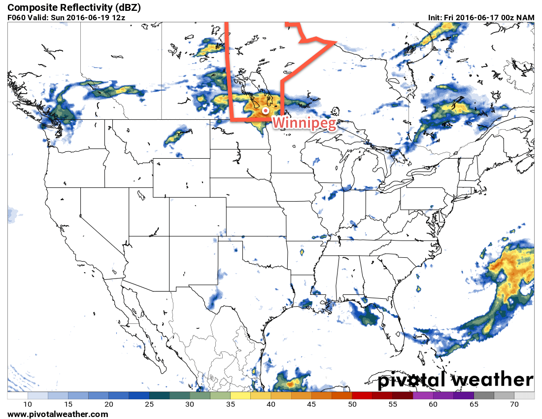
The NAM shows an area of rain tracking across the Red River Valley on Sunday morning.
Sunday will likely bring another bought of convective rainfall to the region. A shortwave riding over the Northern Plains will lift northeastwards into southern Manitoba on Sunday, spreading an area of rain ahead of it. There will be a risk of a thunderstorm associated with it, but at that point the risk looks small. Current indications are that the rain will start in the morning, be fairly intense, and end by midday with a widespread 10-15mm, however speed and timing may change between now and then. Temperatures will be cool with a high in the mid-teens and a low near 10°C. Winds will be moderate out of the southeast at 30-40km/h.
Heading into next week, it looks like things will finally settle a bit and we may get a stretch of warm, dry weather with daytime highs in the upper 20’s, overnight lows in the mid-teens or warmer, and little expected by way of widespread precipitation or significant storm threats.
Winnipeg’s seasonal daytime high is currently 23°C while the seasonal overnight low is 10°C.
The first real notable surge of summer air is on the way for Winnipeg as a broad southerly flow develops ahead of a slow-moving low pressure system moving across Saskatchewan. This organized flow of southerly air will tap into Gulf moisture[1], bringing the first notably humid spell of 2016 to Winnipeg. Alongside the heat and humidity that will move in, there will be a threat of thunderstorm development across Southern Manitoba, of which severe storms are certainly possible.
Today marks the start of the summer surge moving into Southern Manitoba as light southerly winds develop over the Red River Valley and warmer air aloft begins to move into the region. Skies will partly cloudy to mixed through much of the day as temperatures climb to a high near 24°C. The humidity will still be fairly comfortable today with dewpoint values in the low teens.
Heading into the late afternoon and evening, cloud cover will thicken up over Winnipeg & the Red River Valley as some precipitation develops associated with instability ahead of the approaching warm front. Winnipeg will see a decent chance of seeing some light rain overnight, but amounts will likely remain under a few mm. Temperatures will dip to a low near 14°C tonight.
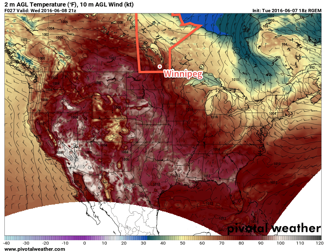
The RDPS shows very warm temperatures in Southern Saskatchewan this afternoon, indicative of the hot air mass set to move into Manitoba tomorrow.
Thursday will be the most significant day over Southern Manitoba as the full brunt of a hot and humid air mass settles over the province. Temperatures will soar to a high near 28°C while the humidity becomes particularly swampy, with dewpoint temperatures likely to climb to the 19-21°C range. This will feel quite sticky, especially as the first humid spell of the year, as humidex values climb toward the mid-30’s for the afternoon.
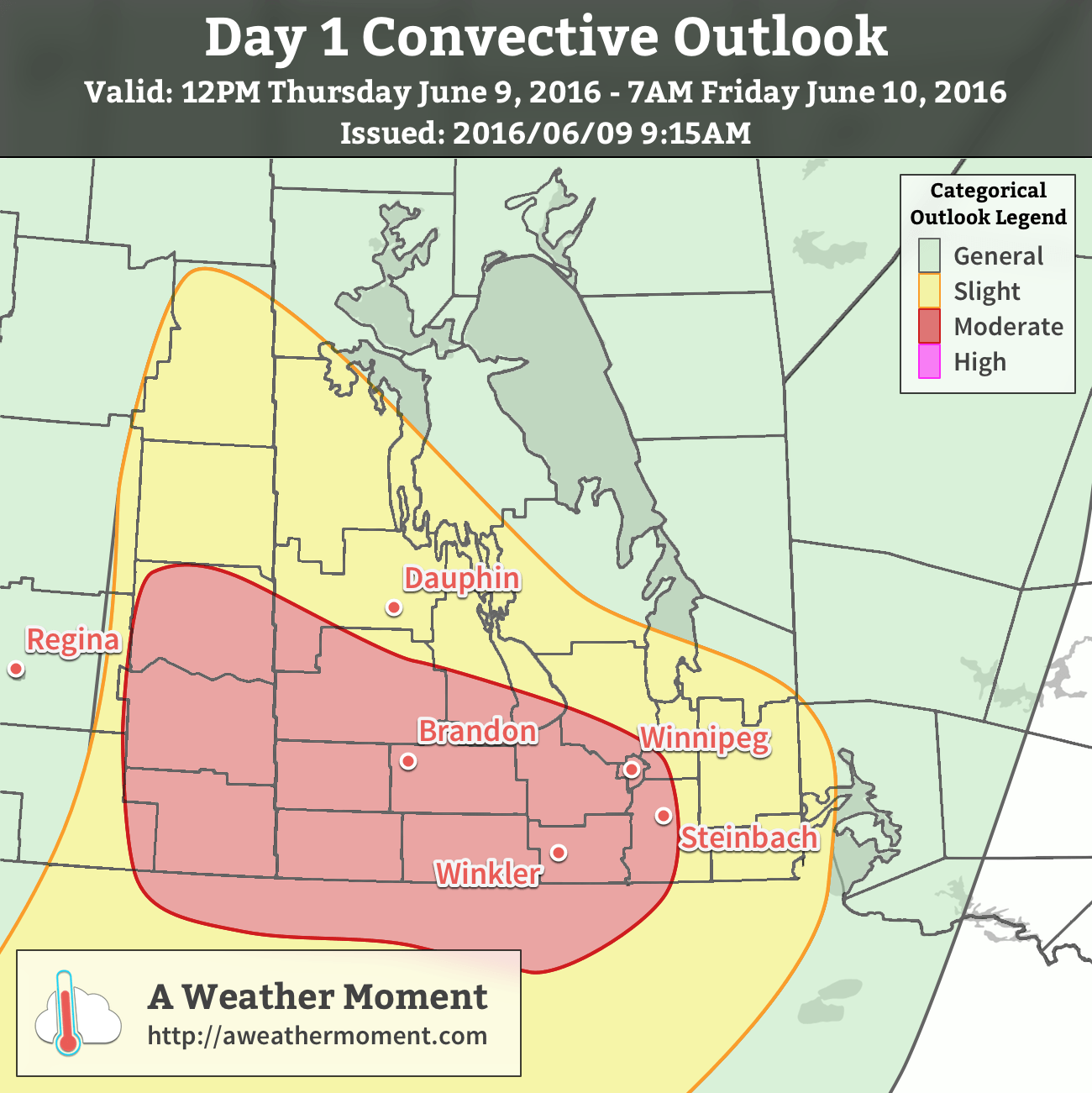
With the heat and humidity in place, attention turns towards thunderstorm potential. This setup has been interesting to watch develop over the last week as models have struggled to resolve exactly how much moisture would arrive in the province and how warm temperatures aloft would get. That said, there’s a severe thunderstorm risk today that will start over southeastern Saskatchewan with afternoon thunderstorm development possible. The threat will then shift eastwards through the evening and overnight with thunderstorms transitioning from surface-based to elevated as the low-level jet strengthens, helping the scattered afternoon activity grow upscale into a larger area of rain and thunderstorms.
AWM Day 1 Convective Outlook valid June 9-10, 2016
Taking a more technical look at it, as usual we return to the basic MIST principles:
Moisture: With surface dewpoints climbing towards or even over 20°C, ample moisture will be in place for thunderstorm development. The low-level jet that develops Thursday evening will also be helping propagate elevated moisture levels northwards.
Instability: Significant instability is in place with MLCAPE values in excess of 2000 J/kg developing over much of th region. MUCAPE values continue above 2000 J/kg through the overnight period. CAPE also appears to be fairly "fat", bolstered by potent mid-level lapse rates over 8°C/km.
Shear: Ample speed and directional shear will be in place with 0-6km bulk shear values of 35-50kt and strongly veering profiles. Low-level wind profiles in eastern Saskatchewan & western Manitoba will favour discrete supercell thunderstorm development with storm motion to the east-southeast.
Trigger: Strong solar insolation coupled with an incipient thermal wave and associated boundaries should provide multiple foci for thunderstorm initiation.
In general, it’s expected that discrete supercell thunderstorms with primary threats of damaging hail, wind gusts in excess of 100 km/h and a non-zero tornado threat. These storms will likely be scattered and progress to the east-southeast. As the evening wears on and the low-level get strengthens, the scattered activity has a high probability of growing upscale and organizing into an MCS[2]. If an MCS develops and moves eastwards, then the primary threats will be heavy rain and damaging hail. There is growing confidence that the MCS will develop into a bow echo, which is a fast-moving storm that produces severe wind gusts. Should this occur, than much of southwestern Manitoba and the Red River Valley will see a very significant threat of damaging hail and severe winds.
Temperatures will remain quite warm on Thursday night with low temperatures throughout the Red River Valley near 20°C.
Friday will continue to be warm with mainly sunny skies once any overnight convection clears out of the region. Temperatures will rocket to the upper 20’s by midday and while the highest humidity will push off to the east, it will still remain a bit muggy with dewpoint values stabilizing near 15-17°C. Winds will shift to be out of the northwest at around 20km/h. Expect a low on Friday night near 15°C.
Winnipeg’s seasonal daytime high is currently 23°C while the seasonal overnight low is 10°C.
In the summer, deep southerly flows over the Eastern Prairies tap into humidity from the Gulf of Mexico and pull it northwards across the Great Plains and into the Southern Prairies. ↩
Mesoscale Convective System: A cloud system that occurs in connection with an ensemble of thunderstorms and produces a contiguous precipitation area on the order of 100 km or more in horizontal scale in at least one direction. ↩