Unfortunately for the water-logged fields of the southern Red River Valley and the many ruined plans of office workers just looking for a couple nice days to spend outside, more unsettled weather will be moving through the Red River Valley this weekend with another round of showers or thunderstorms rolling in on Saturday night into Sunday.
Today will start off with the remaining convection from overnight pushing off to the east of the Red River Valley, with the sun then coming out in the morning and quickly pushing our temperatures up into the high-20’s. Winnipeg will likely be within a few degrees of the daytime high of 29°C by lunch. The rain overnight helped bump up our dewpoints, so until drier air begins moving in from the west this afternoon it will feel quite humid outside with temperatures of 26-29°C feeling more like 33-36°C. Temperatures will cool off tonight thanks to the lower dewpoint values moving in to a low temperature near 12°C.
Saturday will bring mixed skies and cooler temperatures as north to northeasterly winds shunt off the warmer air in place today. There isn’t too much to mention at this point for Saturday, so enjoy it! Temperatures will dip to around 13°C on Saturday night with increasing cloud.
Sunday will likely bring another bought of convective rainfall to the region. A shortwave riding over the Northern Plains will lift northeastwards into southern Manitoba on Sunday, spreading an area of rain ahead of it. There will be a risk of a thunderstorm associated with it, but at that point the risk looks small. Current indications are that the rain will start in the morning, be fairly intense, and end by midday with a widespread 10-15mm, however speed and timing may change between now and then. Temperatures will be cool with a high in the mid-teens and a low near 10°C. Winds will be moderate out of the southeast at 30-40km/h.
Heading into next week, it looks like things will finally settle a bit and we may get a stretch of warm, dry weather with daytime highs in the upper 20’s, overnight lows in the mid-teens or warmer, and little expected by way of widespread precipitation or significant storm threats.
Winnipeg’s seasonal daytime high is currently 23°C while the seasonal overnight low is 10°C.
Sunday Rainfall Update
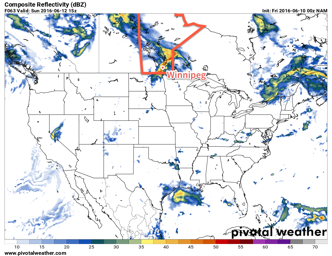
Things still look on track for rain tomorrow here in Winnipeg & through the entire Red River Valley. A potent shortwave continues to lift northwards through Wyoming into Montana, and has now initiated thunderstorm development through eastern Montana & the far western Dakotas. This activity will grow in coverage and continue to lift northwards through the night, spreading into southeastern Saskatchewan in the next 3-5 hours.
This area of rain and thunderstorms will then spread into southwest & Parkland Manitoba for the second half of the overnight period, bringing rain and thunderstorms. In general, 20-30mm are expected, but localized amounts of 40-50mm in thunderstorms are possible.
This area will then spread eastwards into the Red River Valley on Sunday morning. By the time it reaches us, the thunderstorm threat will likely be reduced to just a risk, with the entire system being more of a general area of rain. As it moves through in the morning and early afternoon, it’s likely that most areas will see 10-20mm of rain; this is certainly unwelcome in many areas where agricultural activity is taking a significant hit as a promising start to the year has been undone by persistent rain which has led to waterlogged fields and lost crops.
As the rain tapers off mid-day, a chance for thunderstorms will re-develop through the Red River Valley as any daytime heating leads to some instability through the region. By mid- to late-afternoon everything should be settling down with clearing skies.
Models are beginning to hint that a more prolonged dry period may not occur, with the next rain and storm potential appearing on Tuesday night, and another chance for precipitation on Friday night/Saturday.