Conditions will be mixed across Winnipeg & the Red River Valley through the remainder of the week with today's wet weather & seasonal temperatures giving way to warmer conditions with unsettled conditions building back in for the end of the week.
Today will start off with showers across the southern Red River Valley; there's a chance that we'll see some of the activity here in Winnipeg, but so far this system has been very difficult to get a handle on. Winnipeg may see the precipitation edge into the city this morning, but there's about an equal chance that it will stall just to the east of the city and never make it in.
By this afternoon, the rain should head back off towards Ontario and Winnipeg will be left with cloudy skies that will clear through the afternoon. Temperatures will climb towards a high of 23°C in Winnipeg today, with highs of 22-25°C across the Red River Valley. Expect a low near 15°C tonight under mainly clear skies.
Thursday will be a very nice day through the Red River Valley with a few clouds and much warmer weather. Daytime highs will climb around 28°C while a breezy south-to-southeasterly tap into higher moisture to the south, pushing dew points into the upper teens. This will make things feel slightly muggy, and that high of 28 feel closer to something in the mid-30's. A frontal wave passing through in the late afternoon will bring a risk of thunderstorms to Winnipeg & the Red River Valley through the evening hours. Temperatures will fall towards a low of 18°C under mixed skies overnight.
Friday will bring mixed skies to Winnipeg with drier air moving in behind the passage of a cool front in the morning. Temperatures will still climb to a high near 28°C once again, but by late afternoon significantly more cloud will begin moving into the region as the cool front rebounds and begins pushing back through the region. In the evening, showers and thunderstorms will be possible across the Red River Valley as the warm front slowly pushes northwards. Temperatures will fall to a low near 18°C once again on Friday night.
Long Range
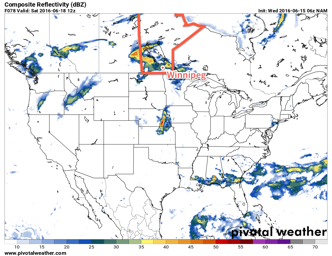
The weekend is looking like it could be a wet one once again. Currently a low pressure system is forecast to move through the region on Saturday, which would likely bring a rainy day to the region with 15-25mm of rain possible. Things will improve a bit on Sunday as the system leaves the region, but a slight chance of showers may linger through the day.
Daytime highs will be in the low- to mid-20's and overnight lows will dip down to the mid-teens.
Winnipeg’s seasonal daytime high is currently 24°C while the seasonal overnight low is 11°C.