Weather Forecasts, Facts and News for Winnipeg & Southern Manitoba
Author: Brad
Brad lives in Winnipeg with his wife and two children and is the founder of A Weather Moment. He has loved weather from a very young age and has followed that passion through his life so far. He received a B.Sc. in Earth Sciences with Specialization in Atmospheric Sciences and is currently employed in the field of meteorology. You can find the author as WeatherInThePeg on Mastodon.
Winnipeg will see another cool day before seasonal temperatures return on Saturday and stick around through the weekend and beyond. Overall the upcoming weather forecast could be described as "fairly boring" with no significant weather events expected in the next 5-7 days.
Winnipeg will see mainly cloudy skies today as a weak upper-level disturbance moves across the province. With all the cloud and a weak northerly wind, below-normal temperatures will persist with a high temperature of just 7°C. The afternoon will bring a slight chance of some shower activity, but it is overall expected to be quite light and may remain north of the Winnipeg. Temperatures will be chilly tonight as temperatures dip to +2°C under cloudy skies.
Saturday will be another cloudy day in Winnipeg and mark the start of the next weather system that, while not directly impacting us, will set the stage for the weather over the region for the next few days. A fairly potent low pressure system will begin building out of Montana into South Dakota, spreading cloud and rain through North Dakota towards the Canadian border. A strong deformation zone should set up just south of the border, keeping the precipitation States-side. In Manitoba, this system will produce primarily cloud and wind. As mentioned, we expect mainly cloudy skies for Winnipeg, and much of the remainder of Southern Manitoba, on Saturday. The wind will pick up out of the northeast, strengthening to about 30km/h here in Winnipeg, with values closer to 40 gusting 60 km/h over southwestern Manitoba.
Some of the cloud will begin to slump to the south on Saturday night as temperatures drop to the -1°C mark.
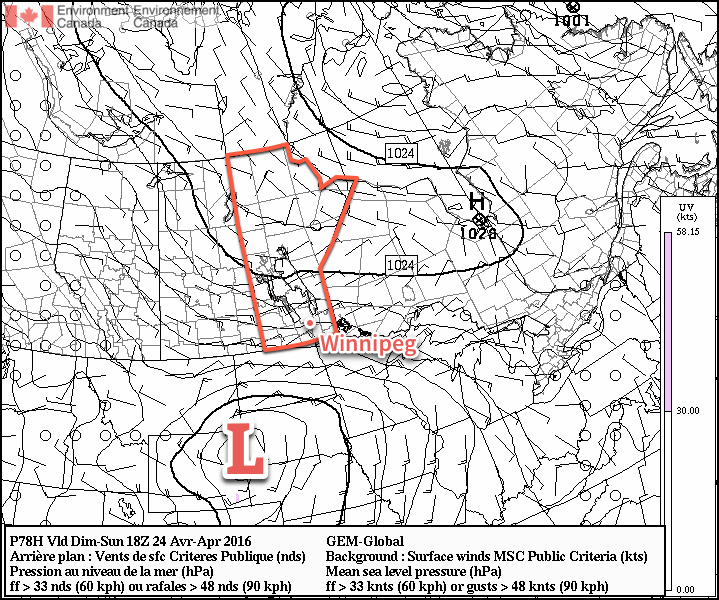
A strong low pressure system (L) in South Dakota will bring windy conditions to the Red River Valley on Sunday.
Sunday will bring partly cloudy skies for Winnipeg as the main cloud shield slumps to the international border.[1] Temperatures will continue near seasonal values with a high of 10°C. Unfortunately, it will feel quite chilly as a brisk northeasterly wind approaching 40km/h develops over the Red River Valley. Temperatures will dip down to the freezing mark on Sunday night once again with winds tapering off.
A quick glance ahead into next week shows pretty much more of the same; some sun, some cloud, and temperatures at or just below seasonal. Not much is expected precipitation wise until a system comes through in the second half of the week and brings the potential for some rain to the region.
Winnipeg’s seasonal daytime high is currently 13°C while the seasonal overnight low is 0°C.
This means that for areas in the southern Red River Valley, skies will likely be more mixed-to-cloudy. ↩
Today will bring a mixed bag of conditions to Winnipeg and area before a cold front sweeps through the region this evening and ushers in cooler air from Northern Manitoba.
We’re off to a misty, drizzle-filled start to the day here in Winnipeg thanks to a large area of stratus cloud that expanded northwards out of the Dakotas overnight. This expansive area of cloud—stretching from southeastern Saskatchewan across southern Manitoba and into northern Ontario—will remain in place until later this morning; by midday, westerly winds will begin building into the region and help to break up the clouds and bring an end to the fog patches and drizzle.
The sun should make an appearance in Winnipeg this afternoon as temperatures head towards a pleasant high of 20°C. The sunshine will be relatively short-lived as a cold slumping southwards out of central Manitoba spreads another batch of cloud southwards.
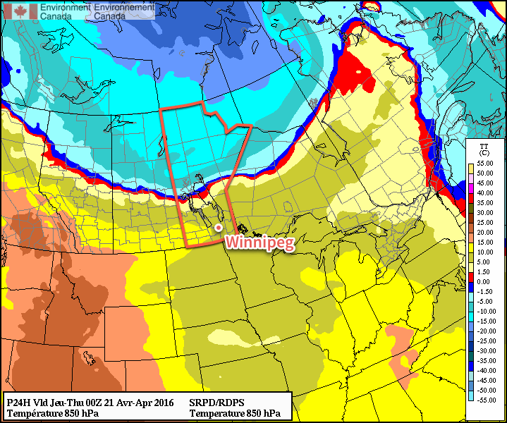
A cold front separates above-normal temperatures in southern Manitoba from well below-normal temperatures pushing southwards through northern Manitoba.
When the cold front slides through this evening, there will be a slight chance of an isolated shower or thundershower. This activity is not expected to be particularly widespread and will taper off very quickly once the sun begins to set. Breezy northerly winds of 20-30 km/h will move in behind the front ushering in cooler air that will send Winnipeg’s overnight low to near +2°C.
Thursday will be a pleasant but cool day with just a few clouds and a high near 8°C. Winds will continue to be breezy in the morning at 20-30 km/h, but will gradually taper off through the day. Expect an overnight low near -1°C with increasing cloud.
Friday will bring mainly cloudy skies as a frontal zone sets up across the eastern Prairies. Winds will be light and there will be just a slight chance of some light shower activity. Expect a high near 8°C once again and an overnight low near +1°C.
Winnipeg’s seasonal daytime high is currently 13°C while the seasonal overnight low is 0°C.
After a wet weekend across much of Southern Manitoba, improvement is on the way with more sun and warmth moving into the region to dry things out.
Today will be downright gorgeous compared to the last few days as the cloud cover that has plagued Winnipeg begins to clear out this morning. The sun should be out by this afternoon and temperatures will climb to an above-normal 15°C. Winds will be out of the northeast around 20 km/h. Temperatures will dip to +1°C tonight under clear skies.
Tuesday will be a beautiful sunny and warm day with just a few clouds in Winnipeg and a high approaching the 20°C mark. Tuesday night will continue mild with a few clouds and a low near 7°C.
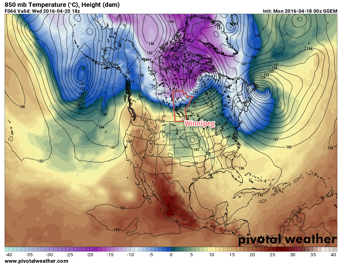
Cooler air (pink/purple) is poised to spill southwards on Wednesday night, but not before Winnipeg enjoys some mild temperatures.
Wednesday will be a nice day, but mark a transition back towards seasonal weather as a cold front slides towards the Red River Valley from the northwest. Winnipeg should see a daytime high near 19°C, but with increasing cloud as the day progresses. By evening, there is a slight chance of some showers moving through the city as the cold front passes. Behind the cold front winds will pick up out of the north to 30-40 km/h. With cooler air moving back into the region, Winnipeg will head towards a low near freezing.
Long Range
Behind this cold front, Winnipeg will transition to a slightly below-normal temperature pattern for a few days. A chance for some light snow or rain returns on Friday as a disturbance moves through the region. Once that passes, it appears Winnipeg will move into a seasonal trend with highs in the low teens and little precipitation expected throughout the first half of next week.
Winnipeg’s seasonal daytime high is currently 11°C while the seasonal overnight low is -1°C.
The end of week in Winnipeg will be wet as a complex series of disturbances bring several waves of precipitation to the region. Storm-total rainfall amounts of 25-75mm are possible with this system, however the amount any one place receives will be highly dependent on the exact location these features line up, which at this point, is quite uncertain.
Rainfall
A few showers or thunderstorms are possible tonight as a mid-level warm front pushes northwards through North Dakota, aided by a 45kt low-level jet. The chance for rain over the Red River Valley will be mainly before 3AM, with the bulk of any shower activity moving northwards into the Interlake.
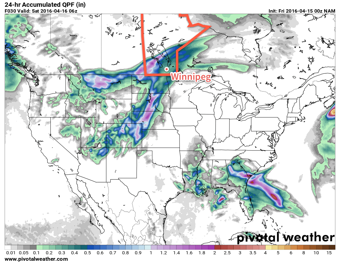
Friday will be a wet day over most of Southern Manitoba as a broad area of rain spreads across the Province along the northern edge of a low pressure system tracking through North Dakota into the Red River Valley and areas east. The main area of precipitation will blossom tonight in eastern Montana and then spread east-northeastwards into southwestern Manitoba near midnight, through the Interlake overnight, and then into the Red River Valley proper early Friday morning.
The rain will taper off through the afternoon over the southwestern portion of the province, and in the late afternoon and evening through the Red River Valley. By the time this area of rain tapers off, general amounts will be 10-30mm over southwestern Manitoba and between 5-20mm over much of the Red River Valley & Interlake.[1]
For the southwestern portion of the province, this will mark the end of the main event. Further east here in Winnipeg and the Red River Valley, things become more complicated. After a brief break on Friday evening, rainfall will re-develop on Friday night along a deformation zone[2] ahead of another disturbance pushing northwards out of the central Plains of the United states. The deformation zone will lie along a line approximately NNE-SSE through the Red River Valley & this will result in a fairly persistent band of rain that abruptly tapers off to the west of this feature.
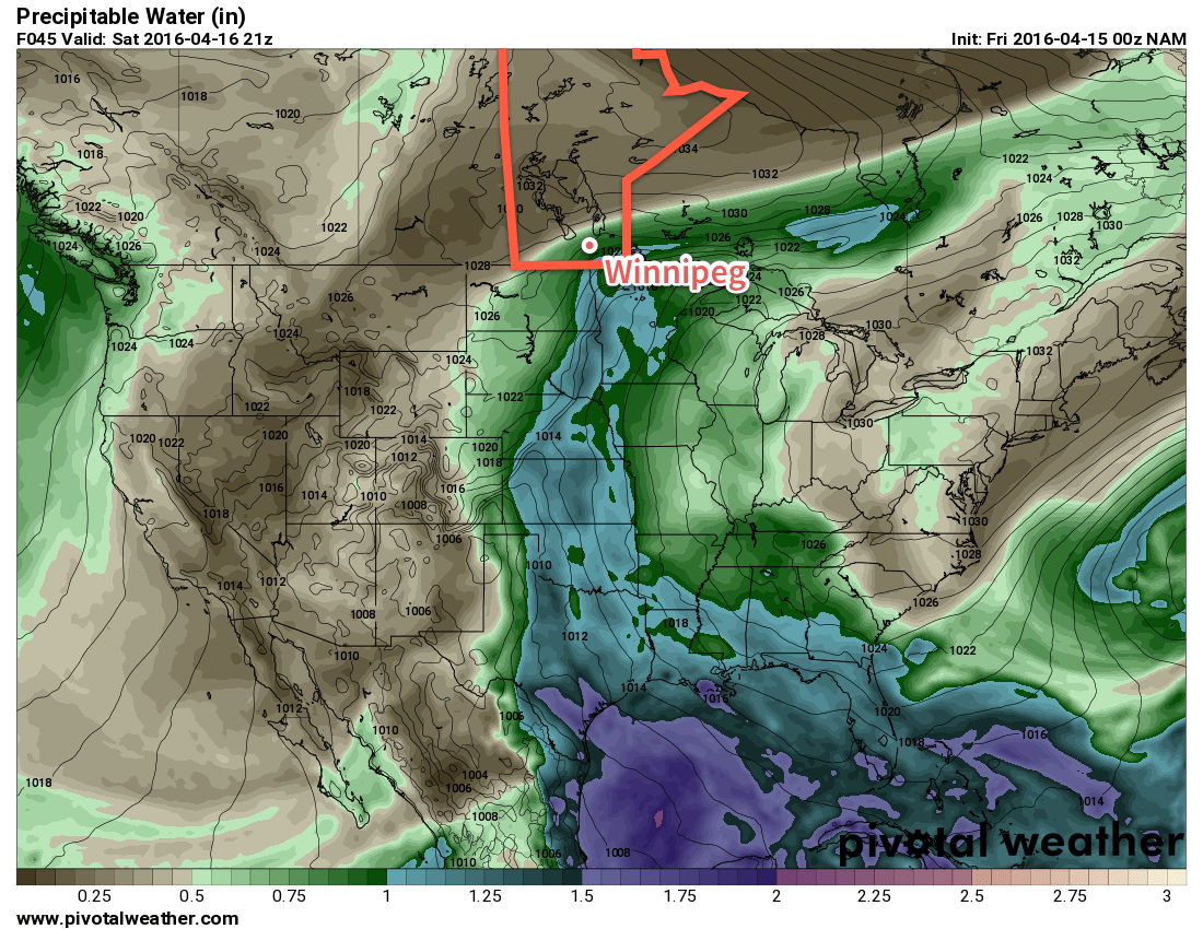
Here’s one shot in the dark at rainfall totals for Friday (from the 00Z April 15, 2016 NAM run).
Saturday will bring cloudy skies and more rain to the region. For much of the day, rainfall will be confined to the east of the deformation zone, however by late in the day, a low pressure system will push through SE Manitoba, pushing rainfall further west into the Red River Valley before everything moves off to the east on Saturday evening. For areas along and to the east of the deformation zone, rainfall totals on Saturday will likely end up in the 15-30mm range, while areas west of the deformation zone in the Red River Valley end up with 5-15mm.
Forecast Rainfall Totals by Area — April 15/16, 2016
Location
Rainfall Total (mm)
Friday
Saturday
Total
SW Manitoba
15-35
Trace-5
15-40
Red River Valley
15-25
Trace-35
15-60
SE Manitoba
10-20
15-40
25-60
Interlake
15-25
Trace-10
15-35
There is high confidence in elevated precipitable water values (relative to April), which confirms the potential of heavier rainfall in some locations on Saturday.
Throughout the duration of this event, it’s expected that all the precipitation will fall as rain, except for the higher terrain of the Riding Mountains & Turtle Mountain, where it may be mixed with periods of snow or freezing rain.
Unfortunately, at this point it’s practically impossible to refine rainfall amounts to anything more precise than these broad categories. As such, I’ve refrained from producing a rainfall forecast graphic as it’s simply too difficult to represent this spread in possible outcomes in a visual manner. We’ll try to provide updates as these systems continue to develop and mature.
The Rest of the Weather
Temperatures will be mild Friday with a daytime high near 12°C, however as the first impulse moves off to our east, cooler air will begin slumping southwards into the Red River Valley as northerly winds increase to 30-40km/h in the evening. Temperatures will dip to around 2°C on Friday night.
Saturday will be considerably cooler with a high temperature near 5-6°C in Winnipeg. The gusty northerlies will continue throughout the day. The wind will begin tapering off overnight as temperatures once again head to a low near 0°C.
Update: Sunday Switches to More of the Same
While originally we forecast that Sunday would bring clearing skies and warm temperatures, however dreams of sunshine will have to wait as this very complicated weather system’s evolution over the past couple days has changed the forecast towards a cooler and wetter variety.
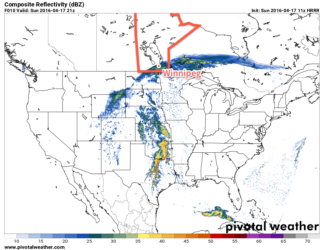
This morning, much of the Red River Valley is still seeing some remnant showers or drizzle from the disturbance that moved through last night. This light precipitation will ease a little bit through the morning, but another disturbance moving into the region midday will spread more rain into Southern Manitoba. Currently entering North Dakota, another area of rain will push north-northeast and then shear out along a southwest-to-northeast oriented deformation zone, allowing rain to push into the southern Red River Valley. Most models indicate that much of the rain that develops will fall through Steinbach and areas eastwards, while areas west and north see little to nothing. Looking at this morning’s satellite imagery, however, and it appears that the deformation zone that will delineate today’s precipitation is a touch further north and west of most model placements.
This simulated RADAR image from the HRRR model valid Sunday afternoon shows rainfall over the Red River Valley.
Some of the high-resolution short-range models such as the RAP and the HRRR are catching onto this fact and, as pictured above, are beginning to shunt the precipitation further to the northwest. So rather than clearing skies, we’ll likely see some shower/rain activity redevelop this afternoon for Winnipeg, the Red River Valley and points eastwards. Amounts will be quite a bit less than the past couple days, with just 2-5 mm for most places and local accumulations in the 5-10 mm range. Any rain activity will taper off overnight.
Other than the rain, it will be cool with a daytime high near 5°C and chilly winds out of north at about 20 km/h. Temperatures will dip close to freezing tonight and we should see clearing and warmer weather begin to work back into the region on Monday.
Winnipeg’s seasonal daytime high is currently 10°C while the seasonal overnight low is -2°C.
Higher amounts that this are possible, but will likely be confined to small regions impacted more heavily by any convective elements that develop within the synoptic rain area. ↩
The deformation zone is a feature in the mid- and upper-atmosphere that firmly separates the warmer, more humid air associated with a low pressure system and the drier, colder air moving in behind it. ↩