Weather Forecasts, Facts and News for Winnipeg & Southern Manitoba
Author: Brad
Brad lives in Winnipeg with his wife and two children and is the founder of A Weather Moment. He has loved weather from a very young age and has followed that passion through his life so far. He received a B.Sc. in Earth Sciences with Specialization in Atmospheric Sciences and is currently employed in the field of meteorology. You can find the author as WeatherInThePeg on Mastodon.
The weather this week will be cool and calm, meaning no big weather makers are in the forecast.
Early Week
Monday Mix of Sun and Cloud. Slight Chance of Flurries. 4°C / -1°C
Tuesday Mainly Cloudy 2°C / -8°C
Wednesday Mainly Sunny 0°C / -8°C
Monday will be a seasonably warm day in Southern Manitoba. A cold front will pass through in the morning, causing the wind to shift to westerly. Temperatures will be in the low to mid single digits.
Tuesday should see seasonable conditions continue in Southern Manitoba. Temperatures will be in the low single digits with a light westerly wind.
Wednesday will be very similar to Tuesday, with temperatures once again in the low single digits and winds being light.
Long Range
The long-range forecast looks to feature mostly seasonal weather. However, we’ll likely see our first snowfall of this fall at some point in the next 5-10 days. It probably won’t be a significant snowfall, but a snowfall nonetheless.
While we mentioned the likelihood for snow or rain for today on Wednesday, things have changed thanks to a stronger-than-expected Colorado Low hitting Southern Ontario. The intensity of this system has amplified the jet stream and as a result the precipitation once expected over the Red River Valley will slide to our southwest. How will the rest of the weekend fare? Read on to find out!
We’ll see very pleasant days today and tomorrow as clouds stay mostly out of the way and we enjoy slightly above normal temperatures1 with daytime highs both days around 6°C. There will be a little more cloud today than there will be tomorrow, but it shouldn’t put a damper on either day. Overnight lows will continue to be seasonal around -5°C.
Sunday will herald the approach of the Next Big System™ to the Prairies. A low pressure system pushing out of Southern Alberta will spread cloud eastwards into Southern Manitoba through the day. While we may start off seeing the sun, by midday we should be mostly cloudy and by the late afternoon we’ll likely be completely overcast. There may be a slight chance of some isolated shower activity by late afternoon into the evening hours, however that threat would be confined strictly to areas along and north of the Trans-Canada Highway.
12hr. accumulated precipitation (liquid-eqivalent) for Sunday night.
Rain showers are likely overnight into Monday morning, but no significant accumulations are expected as the bulk of the precipitation remains through the Interlake. By Monday afternoon all precipitation should have lifted north out of the Red River Valley. While this system looks like it has the potential to deliver a decent amount of snow to the Central Prairies, it looks like it will be a relative non-event here in the Red River Valley.
Things mixed for a day or two before another system tracks into Southern Manitoba mid-week.
Average temperatures for the beginning of November in Winnipeg sit around 4°C. ↩
We’ll see a reprieve from the cold snap across Southern Manitoba over the next few days as temperatures return to more seasonal values, however with that comes the development of a more unsettled pattern that will bring multiple chances for rain or snow to the region over the next week.
Wednesday 6°C / -1°C Warming up with a few clouds.
Thursday 7°C / -1°C Mostly cloudy.
Friday 6°C / -2°C Light snow changing to rain likely.
We’ll see a comparatively beautiful day today with temperatures climbing up to around 6°C under a mix of sun and cloud. The warmer temperatures are thanks to a breakdown of the high-amplitude jet stream that has been in place over North America over the past week and a bit. As the pattern flattens out, it will allow warmer air to push back into Southern Manitoba, which in turn allows us to enjoy non-freezing temperatures. The milder temperatures will stay with us through the remainder of the week.
Thursday (Halloween!) will bring cloudier weather as a weak front aloft begins moving into the area. Temperatures will climb up to around 7°C by the afternoon, making it the warmest day we’ll see this week. Cloudy skies will persist through the night as we drop to around –1°C. Things look to stay nice and dry for the trick or treaters!
Precipitation accumulation expected through the day on Friday, courtesy the NAM.
Friday has a good chance of bringing us some light snow or rain. There’s good agreement that a disturbance will slide down from the northwest on Thursday night, pushing into the Red River Valley through the morning hours on Friday. Precipitation may begin as light snow, but should switch over to rain by midday at the latest. No significant amounts are expected; models are only producing a 2–5 mm water-equivalent of precipitation, so it will be relatively light activity. The precipitation looks to move in fairly early in the morning and will last through much of the day before tapering off around supper time or shortly thereafter. We’ll see a high of around 4 or 5°C and an overnight low of around –2°C.
The Weekend Ahead
Cloudy skies will persist through much of the weekend as a more unsettled pattern develops. Daytime highs look to stick around the low single-digits and overnight lows dropping to a couple degrees below zero. The next chance for precipitation looks to push in on Sunday night through Monday as a system pushes through the region bringing snow to the Interlake and possibly areas further south as well. More on that later in the week.
This week will be a cool one, though we should avoid really frightening weather.
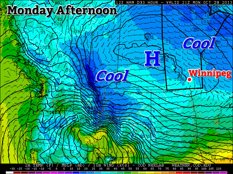
Predicted temperatures on Monday Afternoon
Monday and Tuesday
Monday Mix of Sun and Cloud 0°C / -5°C
Tuesday Mainly Sunny 2°C / -6°C
The weather today and tomorrow will be fairly similar. A surface ridge of high pressure will bring light winds and cool temperatures to Southern Manitoba. High temperatures will be in the low single digits and lows will be below zero. No notable precipitation is expected.
Wednesday
Wednesday Mainly Sunny 5°C / -8°C
Wednesday will see little change from Tuesday. Temperatures will once again be in the single digits, but it will be a bit windier than Monday and Tuesday. Again, no notable precipitation is expected.
Late Week
The late week weather will continue to be on the cool side. Temperatures will remain in the single digits and no significant precipitation is expected.