More Showers Than Thought?

A few systems are expected to bring chances for showers and thunderstorms to Southern Manitoba over the next few days as the upper ridge takes a few days longer to build in than previously thought.

30-Day Rolling % of Normal Precipitation for the Canadian Prairies

30-day % of normal precipitation for the Canadian Prairies. This map depicts the increasing drought conditions over much of the Red River Valley, with most areas only seeing only about 60% of the normal amount of precipitation over the last 30 days.

Offering a slight bit of relief to the dry conditions over the Red River Valley, an area of rain blossomed in North Dakota overnight and has pushed into Southern Manitoba this morning. Amounts are generally expected to be between 5-10mm along the International Border with amounts dropping off quickly to the north. This system will push into NW Ontario by late morning and skies will clear out behind it. Under sunshine our temperatures will soar to nearly 30°C in the afternoon.

The subtropical ridge that was previously progged to push into the Southern Prairies has instead decided to stay more or less where it was for a few extra days, which will leave us with a more zonal flow through this weekend. Fortunately, this means that we’ll have more chances for precipitation than previously thought.

The next chance for rain will come on Saturday afternoon/evening as a shortwave that will move across Saskatchewan today slumps southeastwards across the Interlake and Red River Valley. A couple showers and thunderstorms are likely to fire up underneath the shortwave as it crosses the RRV in the late afternoon. Currently all the convective parameters look to be fairly middling, so I don’t expect any severe weather to occur. Saturday will have a daytime high of 28°C before clouds move in in the afternoon. The low on Saturday night will be around 15°C.

Sunday should be a sunny day with a high near 28°C.

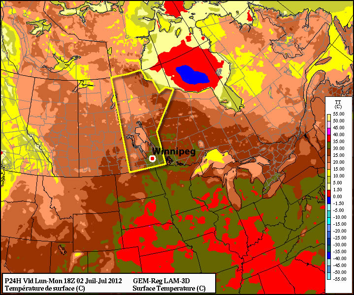
The next chance for rain will be Monday night as a shortwave slumps down the upper ridge that will build into the Western Prairies over the weekend. After that, it looks like the ridge will continue building into the Eastern Prairies, bringing us sweltering hot temperatures ove 30°C by the end of next week.

One Last Shot at Some Rain

Another frontal system tracking across Southern Manitoba today will bring one last shot at precipitation before the sub-tropical high begins to edge northwards and push us back into a hot, dry pattern.

15Z GEM-REG Analysis

Analysis of the GEM-REG model for this morning. The red and blue lines represent warm and cold fronts, respectively.

A cold front that brough severe thunderstorms and numerous tornadoes to Saskatchewan yesterday will push across the Red River Valley late this morning into the early afternoon. What sort of weather we’ll see from this depends highly on how much sunshine we’re able to see beforehand.

A rather large MCS will slowly decay as it moves through SW Manitoba this morning on approach to the Red River Valley. Some uncertainty exists as to what this system will do, however, and the result is dramtically different outcomes.

The NAM wants to keep this system quite progressive and push it eastwards fairly consistently. Under this solution, we’ll see a cloudy morning with some showers and thundershowers pushing through late morning/early afternoon. There’s a chance that rain could be fairly heavy under some of the thundershowers. Westerly winds would build in this afternoon flushing out the moisture in the Red River Valley and returning us to much more comfortable dewpoints in the low teens.

The growing trend in allh the other models, though, is for this system to stall out for a while over SW MB / extreme western RRV. If this is indeed what happens, things could be a little more interesting. Should the sun be able to poke through even a bit, that heating combined with the high surface dewpoints (should be in the 20-23°C range tomorrow morning) would build our CAPE values into the 2000 – 3000 J/kg range. That, combined with good deep shear and a SE wind at the surface veering to SW aloft, could provide an environment favorable for strong storms. The main threats would be heavy rainfall due to the slow-moving nature of the system (this threat would be centralized over the Western Red River Valley), strong winds and large hail. Stronger winds pushing in on the backside could favor the development of a squall-line type feature, but if they’re late to the party, a few isolated supercells certainly aren’t out of the question.

My take on all this? I think we’ll see some middle-ground solution play out. I think we’ll have a chance at seeing a bit of sun this morning, and by late morning some showers and thunderstorms will start pushing through the RRV. One can’t ignore the potential that exists for strong convection, and in that regard I would agree with the SPC’s “See Text” analysis for ND into Southern MB. The potential is there, but I wouldn’t say it’s likely. I hope that many places across the RRV see some rain as this front comes through, because it may be our last chance for a while…

8-14 Day Temperature Anomoly Outlook

NAEFS 8-14 Day Temperature Anomoly Outlook. The large area of red over the Canadian Prairies indicates a high probability of warmer than seasonal temperatures through the 8-14 day time period.

After this system, the sub-tropical high will begin to build northwards again, pushing plenty of heat into Southern Manitoba. Daytime highs will remain in the high 20’s to low 30’s through much of the next 7-10 days, with nary a drop of rain in sight for the Red River Valley. After many places have gone two weeks without any measureable precipitation, perhaps not the best of news.

We’ll keep a close eye on the storms this morning and post updates in the comments as the system develops!

Staying Hot, Storms Possible

This week will start out right where last week left off – hot!

Monday's temperatures at 1pm

Temperatures at 1pm on Monday. The dark green colour represents temperatures between 30 and 35C.

Today will be another hot and humid day in Southern Manitoba. High temperatures are expected to be in the upper twenties, or possibly thirty degrees, with thunderstorms possible both in the morning and later in the day. There will some cloud and possible rain or thunderstorms during the morning from a decaying thunderstorm complex. The speed at which this complex clears the region will determine how hot it will get. The progress of this complex will also determine if there is a second round of storms on Monday afternoon and evening. If it stays cloudy all day with temperatures remaining low then it is unlikely that there will be a second round of storms later in the day. Based on current model guidance it does appear that the clouds will clear out in the afternoon, but there remains some uncertainty with this.

Tuesday will be hot once again, but somewhat less humid than Monday. Temperatures will be up near 30C, but thunderstorms are not expected.

Wednesday will be yet another tricky forecast. A cold front is expected to swing through Manitoba at some point on Wednesday, but it is not entirely clear when that will happen. If the cold front goes through in the morning the day will be warm, but not humid, with highs in the mid to upper twenties. However, if the front only goes through in the evening it will be hot and humid with the risk of severe thunderstorms. The details of Wednesday should become more clear over the next day or two.

You’ll probably be surprised to hear that more hot weather is expected to start July (hint, I hope you’re NOT surprised). Models point to continued hot weather for at least the next 7-10 days as we roll smoothly in the heart of summer.

A quick note…Myself and Matt will be chasing south of the border today! You can keep tabs on our progress using the twitter feed by clicking through below.

new TWTR.Widget({
version: 2,
type: ‘list’,
rpp: 30,
interval: 30000,
title: ‘July 2nd, 2012’,
subject: ‘AWM Storm Chase’,
width: ‘auto’,
height: 500,
theme: {
shell: {
background: ‘#3c3c3c’,
color: ‘#eeeeee’
},
tweets: {
background: ‘#eeeeee’,
color: ‘#2c2c2c’,
links: ‘#489ce1’
}
},
features: {
scrollbar: true,
loop: false,
live: true,
behavior: ‘all’
}
}).render().setList(‘WeatherInThePeg’, ‘awm-team’).start();

Warm Weather to Continue, Slight Chance of Showers

Our warm weather is expected to continue as a significant upper-level ridge continues to strengthen over Southern Manitoba. The weather will slowly grow slightly more unsettled into next week.

500mb Winds valid Saturday Morning

500mb winds valid Saturday Morning. The building/approaching upper ridge is shown by the ridging in the black height contours; I’ve marked the ridge axis with the thick blue squiggly line.

We’ll see sunny skies today with a daytime high of 28°C today and lighter winds only at about 20-30 km/h. Warming temperaures aloft will bring warmer nights back into the cards, with our overnight low tonight and through the weekend expected to sit only at about 17 or 18°C. Fortunately, our dewpoints should remian in the low teens, which will help make the warmth more comfortable.

A weak low sliding across Central Manitoba on Saturday will spread an area of rain and thundershowers through Parkland Manitoba across the Interlake and into NW Ontario. For those heading out to Dauphin for this weekend’s Country Fest, be sure to bring your tarps for your tents and your rain slickers; you’ll likely get a little wet on Saturday morning. Fortunately, conditions should be considerably better than, well, many of the recent years. Here in the Red River Valley, there’s only a slight chance of showers on Friday night/Saturday. For Winnipeg, Saturday will be a mix of sun and clouds with a high near 28°C.

Conditions improve again on Sunday, with more sunny skies across Southern Manitoba and highs near 30°C.

The upper ridge that has brought this beautiful weather to us will begin to break down early next week, bringing slightly more unsettled weather back to the Prairies. It currently looks like we’ll see some rain on Monday evening, and then building heat and humidity mid-week with the threat of thunderstorms. We’ll have more on that first thing next week!