Elsewhere in Weather News: April 11th, 2015

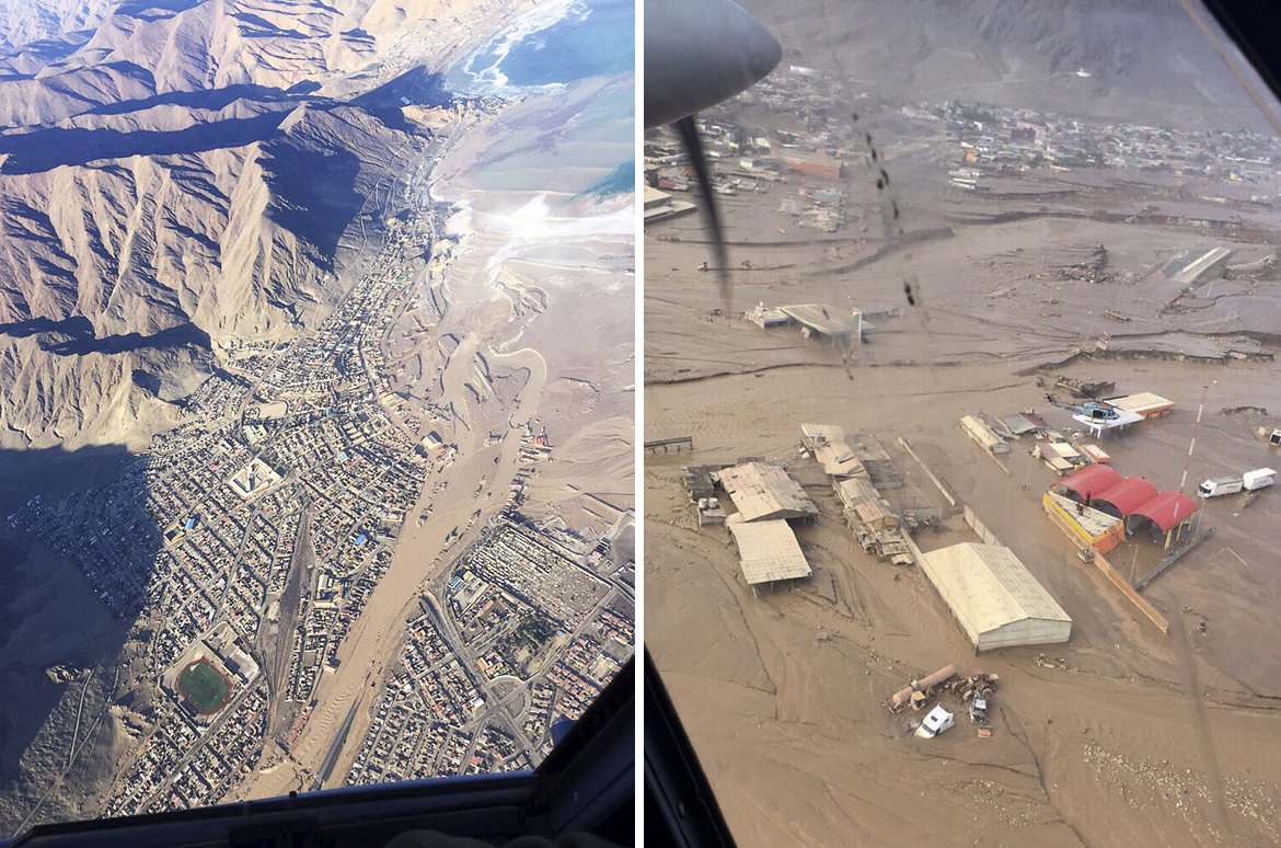
Severe Weather Outbreak Strikes Plains and Midwest

As April rolls around the severe weather season in the United States is on an uptick, and with that comes a higher threat for tornadoes. The latest severe weather outbreak occurred Wednesday and Thursday of this past week and hit hardest a few small communities of northern Illinois.

[map autofit=”1″ disable_scrollwheel=”1″] [pin]Medicine Lodge, Kansas[/pin] [pin]Fairdale, Illinois[/pin] [/map]

The setup on Wednesday was a fairly typical setup that you would see for a Southern Plains outbreak – surface low in central Kansas with sharp warm front extending eastwards and dryline extending southwards. This, combined with an upper-level trough moving in aloft, destabilized the environment sufficiently for supercells. Only a few tornadoes were observed on Wednesday, with most spotted just west of Wichita (including a large cone tornado near Medicine Lodge) and one unconfirmed in western Oklahoma. No damage was reported as tornadoes mainly touched down in open areas.

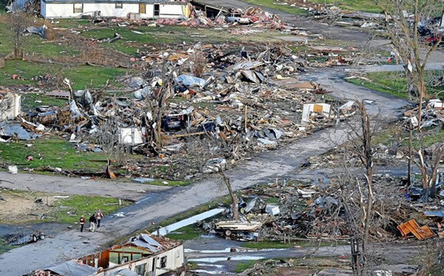
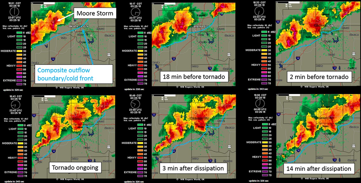
Thursday was a different story however, as the system progressed eastwards. The main risk for the day zeroed in to an area near the triple point where both CAPE and shear values were high and surface winds were slightly more backed compared to further south along the cold front. Once again, supercells were triggered in the early evening hours – this time in northern Illinois. One supercell near the triple point stood out from the others however; there no other cells to its southeast to inhibit growth and it latched along the warm front. What came of this supercell was a long tracked tornado that was on the ground for an estimated 25-35km and measured just less than a kilometre in width. It tore through mostly rural area and outskirts of two other towns before striking the town of Fairdale, Ill, which sustained heavy damage from the twister. On Friday, National Weather Service teams were out to examine the damage and gave it a preliminary rating of EF-4 (winds of about 315km/h). Two people were killed and a dozen more injured by the tornado. Cleanup is currently underway in the town as calmer weather sets in for the weekend.

Note: there is some strong language near the end of the video clip

Elsewhere in Weather News: April 4th, 2015

Rare Rainfall Event Strikes Chile

A rainfall event that occurred near the end of March in Northern Chile did some major damage to numerous towns in the region. The storm system that brought the rain was the product of an upper level low that remained nearly stationary for several days in the area. The rainfall amounts, which might seem insignificant to Manitobans, are significant for that area because the storm system brought rain to one of the few places on the planet that receives very little precipitation every year – the Atacama Desert.

[map autofit=”1″ disable_scrollwheel=”1″][pin]Santiago[/pin][pin]Antofagasta[/pin][/map]

The flooding and mud flow event affected about 30,000 Chileans and destroyed 5,900 houses.  In the hardest hit regions only about 65mm of rain fell, but due to the extremely dry soil conditions in the region – which have trouble letting rainfall percolate through – flooding occurred. According to Wundergroud meteorologist Jeff Masters, Antofagasta recorded 24.4mm of rain in 24 hours while their average precipitation per year is 3.8mm. Santiago, Chile recorded 35.7mm of rain during the event, which is a significant amount in comparison to the 6mm total rainfall they typically receive during the entire month of March.

Aerial images of a flooded region in the Atacama just south of Antofagasta. (Source: Reuters)

The flooding rains triggered flash floods which swept away cars, houses and washed away one of Chile’s main highways in 3 places in the normally arid part of northern Chile. In total, 24 people have perished from this event and there are still over 50 that are missing where the mud flows occurred. Rescue efforts are still ongoing for people in remote locations and the cleanup in the towns has begun as 7,000 troops have been brought in.


In other news, the Philippines are expecting typhoon Maysak to make landfall this weekend. Maysak was once a super typhoon (category 5) but has since encountered cooler waters of the Western Pacific and has weakened to a category 1 typhoon as of Friday night. The main risk with this storm is the heavy rainfall that it will bring to the Northern Philippines.

Elsewhere in Weather News: March 28th, 2015

First Significant Severe Weather Event of the Season Strikes Oklahoma

This past Wednesday severe storms erupted across much of Oklahoma bringing with them very large hail and even tornadoes. It was the biggest severe weather day this year in the states, up to now (but many more are to come). A surface low was located in central Oklahoma with dryline extending southward, cold front crashing south from the north side of the low, and a warm front extending northeastwards from the low. There were two main focus areas for the storms – along the dryline and near the triple point/along the warm front. A moderate risk was issued by the SPC and covered the areas of concern. The outlook also included a 5% tornado risk with 45% hatched hail probabilities. A moderate jet streak was in place with dewpoints in the high teens, which together provided sufficient shear and CAPE for supercells.

[map type=”terrain” autofit=”1″ disable_scrollwheel=”1″] [pin]Sand Springs[/pin] [pin]Moore[/pin] [/map]

As expected, several storms initiated on Wednesday afternoon and grew into supercells. Two supercells were of most concern before storms consolidated into squall lines: one near Tulsa and one near Oklahoma City. The storm that approached Tulsa showed strong rotation on radar early in its lifetime –a tornado warning was able to be issued well before it hit the city. By the time it reached a suburb of Tulsa, Sand Springs, a tornado touched down and tore through a trailer park. In addition to that, hail, the size of tennis balls, were reported in Tulsa’s metro region as the supercell’s hail core passed over the city. The tornado (preliminary rating of EF-2) injured over a dozen people and one person lost their life in the trailer park.

Aerial view of the damage to the trailer park in Sand Springs. (Source: Tulsa World)

The Oklahoma City storm fired off the dryline initially but then got undercut by the cold front – meaning it had little tornado potential. Interestingly enough, the supercell was able to catch up to the cold front and interact with it, enhancing the vorticity in the area – likely being a contributing factor to the formation of the tornado. With this mesoscale interaction playing a significant part in the cause of the tornado, not much lead time was provided to residents (it happened quickly). Unfortunately the twister (preliminary rating of EF-1) touched down in the city of Moore, OK which got hit by a devastating twister in 2013 and had seen two other strong tornadoes since 1999. No injuries were associated with this one, thankfully.

Compilation of radar images before/during/after the Moore tornado showing the storm's interaction with the cold front. (Image compilation by @VORTEXJeff / Twitter)
Compilation of radar images before/during/after the Moore tornado showing the storm’s interaction with the cold front. (Image compilation by @VORTEXJeff / Twitter)

The pattern could become active again by the middle of next week, but it is still too early to be certain. April to late May is typically the busiest time of the year for severe weather in the Southern US Plains, due to plentiful moisture before the jet stream shifts further north for the summer.

Elsewhere in Weather News: March 21st, 2015

Maritimes Experience a Winter to Remember

With spring now in place Maritime residents would expect to see more forgiving weather than they have been experiencing this past winter. However, this has not been the case this past week. The East Coast has been hit with another strong coastal storm that brought blizzard conditions and large amounts of snow Tuesday-Wednesday. A fairly deep low pressure system was anchored just off the coast and drew in some cold air in behind – conditions right for a blizzard.

[map autofit=”1″ disable_scrollwheel=”1″] [pin]Halifax, NS[/pin] [pin]Saint John, NB[/pin] [/map]

Halifax was especially hit hard by this storm with a general 35cm falling in the city, with some higher amounts reported. These combined with winds that gusted up to 113km/h to create blizzard conditions. Schools, businesses and government offices were forced to shut down and no public transit was running. Currently, Halifax has a whopping 93cm of snow on the ground which almost doubles the old record of snow on ground of 51cm in 1967 for today (records for snow on ground have been kept since 1955 in Halifax). Saint John, NB even had more snow than that on the ground after the storm – 169cm of snow was on the ground Thursday.

Sidewalks in Halifax are getting quite narrow after the most recent snowstorm. (Source: Twitter/@HadynWatters)

Unfortunately, yet another system is set to affect the Atlantic Provinces as another strong trough makes its way towards the East Coast. The storm will really ramp up later this afternoon – numerous types of precipitation will be in play, with mostly rain near the shoreline, transitioning to mixed types and finally heavy snow as you head further inland. The highest snowfall amounts are expected to be around 40-50cm where it will be all snow, and as much as 20mm of rain could fall in Halifax. City crews have begun clearing city drains to limit the flooding that could take place if most precipitation falls as rain in Halifax.

In other news, Australia has been hit with another strong cyclone this week. The cyclone had a fairly small inner core, but still managed to bring winds of up to 170km/h near Cooktown and a decent storm surge to the coast. Thankfully no injuries were reported with the storm and it is currently in the dissipating stage over northern Australia.