Elsewhere in Weather News: March 14th, 2015

Powerful Cyclone Strikes Pacific Islands

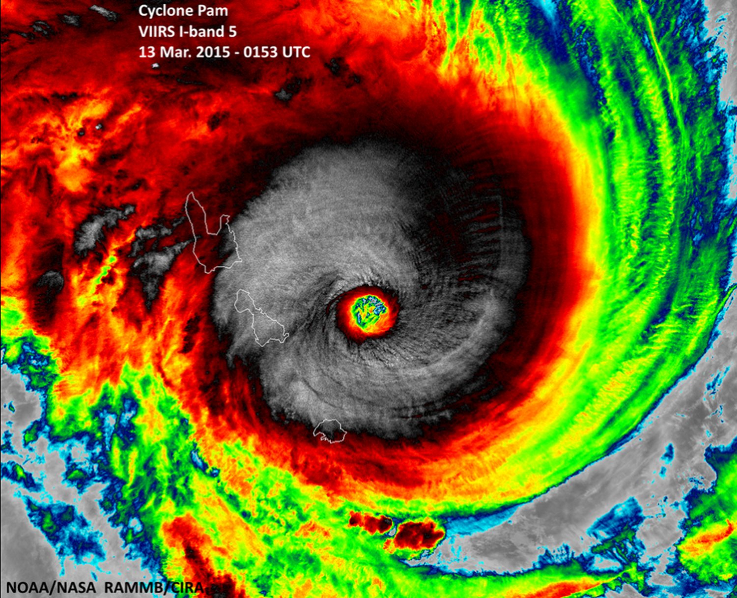
The strongest Pacific cyclone of 2015, Pam, struck the small island nation of Vanuatu located in the South Pacific this past week and brought with it extreme conditions as it topped the cyclone scale at a category five storm.

[map autofit=”1″ disable_scrollwheel=”1″] [pin]Port Vila[/pin] [pin tooltip=”Where Pam formed”]-7.092716, 169.442139[/pin] [/map]

The cyclone developed about 1,000km northwest of Fiji last weekend as an area of thunderstorms organized under ideal conditions – sea surface temperatures were very high in the region, as high as 31°C, and shear was minimal. Pam continued to organize early this week. It struggled as it ingested some dry air into its core while heading towards Vanuatu but by Thursday morning it formed a large eyewall that was fairly symmetric. This meant that it had fought off the dry air and was intensifying rapidly. Peak strength was reached several hours before it reached the Vanuatu Islands, winds were sustained at 270km/h, gusting over 300km/h, and pressure bottomed out at extremely low values estimated by satellites to be around 890mb. Early Friday morning the storm’s eye passed very close to several of Vanuatu’s islands making it a worst case scenario situation. The islands were battered with 250km/h winds, storm surges of 6-8m and extremely heavy rainfall.

Typical buzz-saw appearance of a category five cyclone seen as Pam approached Vanuatu and was near peak strength. (Source: NOAA)

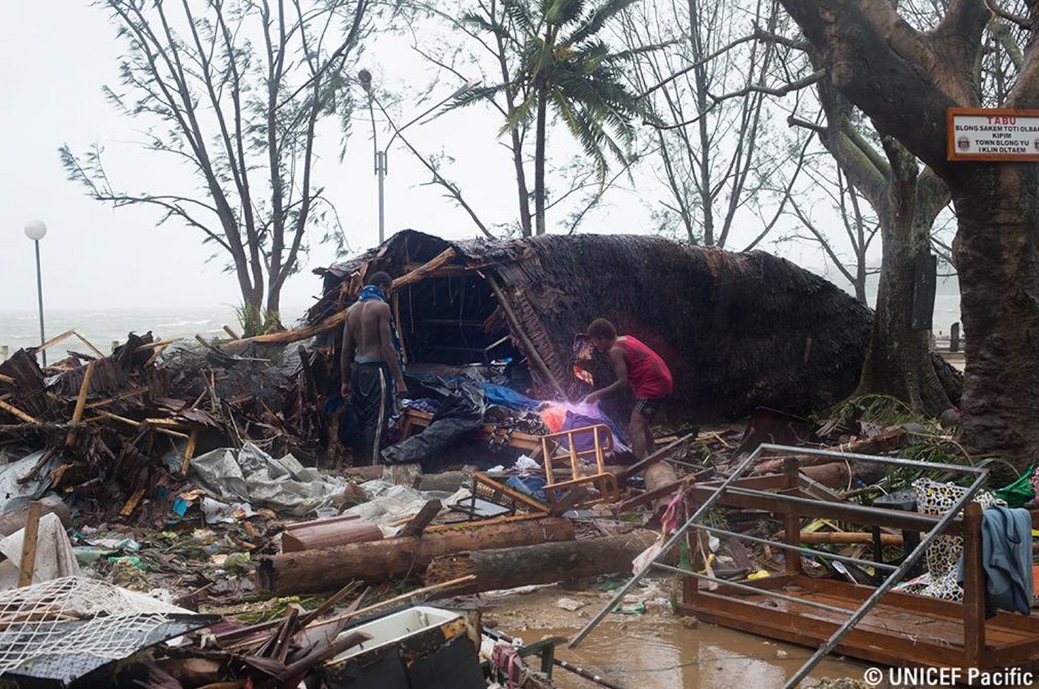
As of Friday evening rescue efforts were still underway while searchers made their way into remote regions that were completely isolated from the storm. Overall the infrastructure on the islands is not the best, with some houses simply made out of mud resulting in more damage than you’d typically see in a developed country. The largest city, Port Vila, was reported to be out of power and running water and had debris scattered across roads making travel difficult. There are unconfirmed reports of numerous deaths associated with this storm, but they have not been confirmed yet.


Damage seen on Friday evening (our time) as Pam was on its way out. (Source: UNICEF Pacific)

After Pam has finished its swipe through the Vanuatu islands, it is not expected have any other significant effect on any other island nations as it heads Poleward where it will weaken. The Pacific/Eastern Indian oceans have been extremely active this week, not only because of Pam, but there have been three other cyclones that were active at one time this week. Two of these made landfall on Australian soils (category three and category two), with minimal damage reported. With that said, there are no other areas of interest for possible formation of other cyclones as of Friday night.

Elsewhere in Weather News: March 7th, 2015

Winter Storm Races across Southern, Midwest US

This past week a strong late season winter storm made its way across the southern and east-central parts of the United States bringing with it all kinds of precipitation: rain, snow, ice pellets and freezing rain. An Arctic front pushing south across the region was the culprit for the mixed precipitation types. Warm air was able to ride over the cooler air racing south near the surface which made for a melting layer above ground and able to melt/partly melt the precipitation. Before it reached the ground the precipitation encountered below freezing temperatures once again which resulted in the freezing rain, or ice pellets if the melting layer was not as deep.

Sounding from Little Rock, AR show a melting layer with below-freezing temperatures closer to the surface.  Black line is the 0°C isotherm.
Sounding from Little Rock, AR show a melting layer with below-freezing temperatures closer to the surface. Black line is the 0°C isotherm.

Large traffic jams on the freeways due to accidents, school closures and power outages were the result of the storm and 13 deaths across several states were directly related to the storm. Impressive and unusual snow amounts for this time of the year were recorded anywhere from Dallas, Texas to Lexington, Kentucky. Here are a few impressive amounts recorded from the storm, provided by the National Weather Service:

  • Lexington, KY: two-day total of 43.4cm (all-time two day record)
  • Tupelo, MS: one-day total of 18.5cm (second snowiest day on record)
  • Dallas, TX: storm total of 8.9cm
[map type=”terrain” autofit=”1″ disable_scrollwheel=”1″] [pin]Lexington[/pin] [pin]Tupelo[/pin] [pin]Dallas[/pin] [/map]

No more snow is expected in the near future, but record-breaking cold temperatures followed last night. Warmer and closer to normal temperatures are on the way for next week as a pattern change takes place and colder air remains locked up further north.

Elsewhere in Weather News: February 28th, 2015

Middle East Sees Snow and Associated Avalanche Danger

This past week the Middle East saw some interesting weather associated with a slow-moving low pressure system that made its way all the way from Turkey to northern India.

[map autofit=”1″ disable_scrollwheel=”1″] [pin tooltip=”Istanbul”]41.005270, 28.97696[/pin] [pin tooltip=”Panjshir”]35.335047, 69.716778[/pin] [/map]

The system first impacted Istanbul, Turkey last week which significantly affected travel across the city as it dropped significant amounts of snow. Most of the precipitation in the region came as rainfall ahead of the low pressure system, but cold air wrapped around on the back side of the system resulted in snow squalls developing off the warm waters of the Black Sea. These snow squalls that formed dropped anywhere from 5 to 20cm, and even locally higher amounts in eastern Istanbul. With the snow that fell earlier in the week, in addition to the fresh snow, one part of the eastern township of Istanbul was able to break its snowfall depth record by recording a snow depth record of 75cm. In other parts of Istanbul depths generally ranged from 20 to 40cm. As many as 200 flights were cancelled as a result of the snow and numerous trees could be seen snapped across the city.

Radar image of strong snow  squalls coming off the Black Sea last week.
Radar image of strong snow squalls coming off the Black Sea last week.

Weather in Istanbul is expected to remain above the freezing mark for the weekend, thus the melt that has been ongoing late this past week will continue. Although it’s not unheard of to get snow in the winter in Istanbul, the average snow depth usually remains below 10cm for the winter months. No more snowfall is expected in the next week or so for the city.

The storm slowly continued its trek east dropping more snow and mixed precipitation in Middle East countries such as Israel and Jordan before reaching Afghanistan. Afghanistan and northern India saw major snowfall as a result of this system, especially at higher elevations. As much as 100cm fell in northeast Afghanistan, enhanced by local topography. Several avalanches were also triggered in the region of Panjshir and buried over 100 houses that were located on a mountainside, leading to the deaths of over 200 hundred residents sadly. The northeast part of Afghanistan is a fairly poor region of the country with houses built in dangerous locations that are prone to avalanches and landslides – deadly avalanches are not unheard of and have last occurred in 2012.

Elsewhere in Weather News: January 10th, 2015

Bushfires Rage across Southern Australia

Dangerous wildfires flared up in the tinder-dry Adelaide region of Southern Australia early this past week, forcing residents to evacuate their homes.

It is not known what started the large bushfires, but weather conditions were the primary factor as to why the wildfires were able to spread so quickly. Long-term drought which has reached severe levels in the region was the first cause for concern that bushfires were possible. This past week’s summer-like weather was what caused the risk to turn into reality as temperatures rose anywhere between the mid-30s to as high as 42.5°C in the region. These temperatures combined with strong, dry (northerly) winds blowing from central Australia was all that was needed to fuel the fires. In total, a few thousand people had to be evacuated and about 40 houses and 12,500 hectares were lost from the bushfires even though nearly 2,000 firefighters battled the flames. The good news is that no severe injuries were reported and firefighters were able to save nearly 1,000 houses in the region.

Picture taken last Sunday outside Adelaide of the bushfires. (Source: Matteo Barr // @Matteobarr)

Since mid-week fires have been under control, mainly due to more favourable weather conditions. A trough of low pressure brought both rainfall and cooler temperatures. The bushfire season is typically most severe from December to March in Southern Australia as temperatures soar and rainfall is scarce (January average of 25mm). Weather in the Adelaide region looks to remain fairly tame as the trough of low pressure lingers and brings overcast skies with occasional showers and cooler temperatures.