Slow Slide To Cooler & Rainy Weather

Winnipeg will see the weather slide from September Summer™ to seasonal to cool and rainy over the next few days as a developing storm system in the Northern Plains gets set to bring a major pattern shift to southern Manitoba.

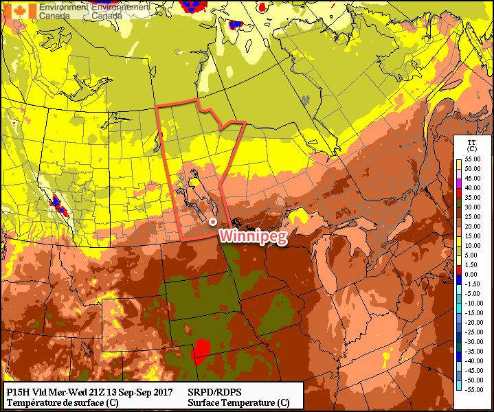
Today will continue the September Summer™ for Winnipeg and the Red River Valley as daytime highs climb well above-seasonal into the mid-20s under nothing but sunshine. Winds will be fairly light today too at just 15-20 km/h, making for a gorgeous day. Some cloud cover will move through tonight as temperatures dip to a low near 13°C.

Warmer than seasonal daytime highs will continue for another day across southern Manitoba

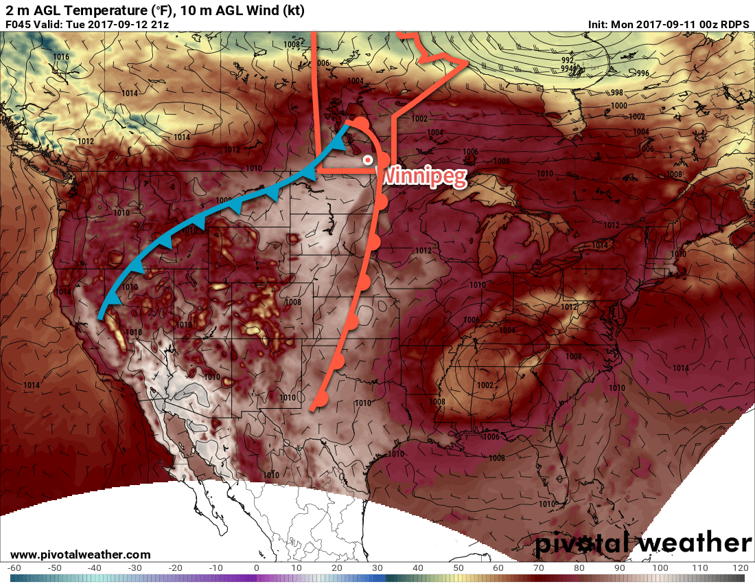
Thursday will see the beginning of a major pattern change as a major low pressure system gradually organizes through the northern plains of the United States. As it does so, a northeast wind to 20-30 km/h will begin tapping cooler air from the central Prairies, returning near-seasonal temperatures back to Winnipeg and the Red River Valley. Skies will be mixed with increasing cloudiness overnight.

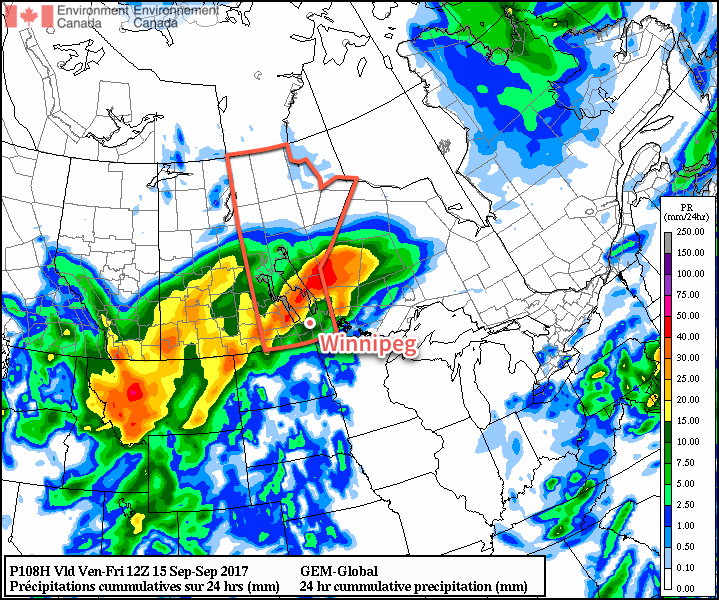
Friday’s dominant weather feature will be a trough of low pressure developing across central North Dakota into southeastern Manitoba in response to a low pressure system tracking into Nebraska out of Wyoming. This trough line will support the development of a large area of rain that will spread northeastwards from western North Dakota along the trough, likely arcing through southwest Manitoba and across the Red River Valley into the Whiteshell.

Rain will spread northeastwards out of Montana and western North Dakota on Friday morning

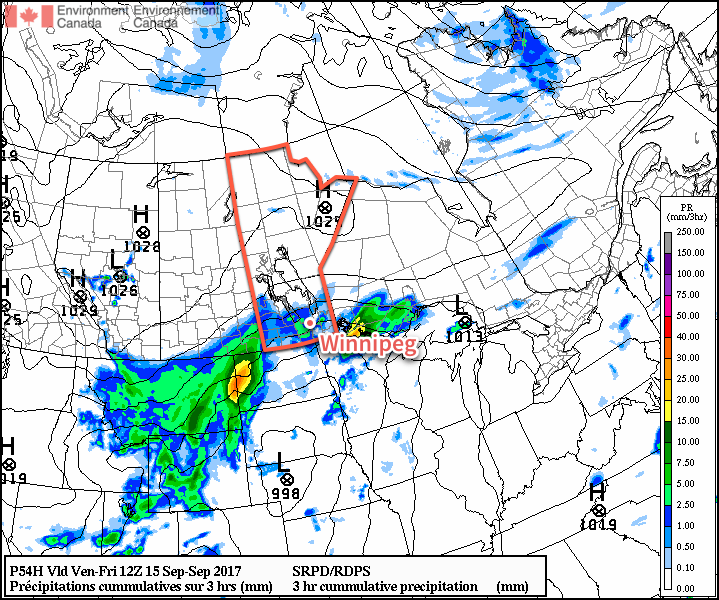
This feature has all indications that it will be a prolonged rainfall event, with rain beginning Friday morning and continuing into Saturday morning. Total rain will be variable and dependant on whether or not any embedded convection develops, but general amounts of 20-30 mm look quite likely. With all the rain, temperatures will be quite cool with highs well below-seasonal in the low teens.

Long Range

Unsettled weather will continue on Saturday with improvement on Sunday, but the chance for more rain will return on Sunday night into Monday morning. Temperatures will remain below-seasonal through the weekend.

Into next week, temperatures will return to near-seasonal values, but it looks like there will be multiple chances for rain as several disturbances cross the Prairies.

Winnipeg’s seasonal daytime high is currently 18°C while the seasonal overnight low is 6.

More Scorching Summer Temperatures Ahead

Daytime highs will head back into the 30’s early this week as a low tracking across the northern Prairies spreads well above seasonal temperatures eastwards.

In the wake of a cold front that moved through yesterday evening, today will bring temperatures cooler than Sunday but still well above-seasonal. A weak ridge of high pressure will keep skies clear with winds out of the west at 20-30 km/h as temperatures climb to a high near 26°C. With dew points falling to just 1-2°C, it will also be bone dry out there. Expect a low near 16°C tonight.

A low pressure system tracking across the northern Prairies on Monday night will begin drawing a very warm air mass eastwards out of Alberta and across the Prairies. This warmer air will arrive in Winnipeg on Tuesday with a southwesterly winds of 20-30 km/h pushing temperatures up into the low 30’s. Skies will be cloud-free as well, making for a scorcher of a day. The winds will ease in the afternoon as a weak low pressure system tracks across the valley, and then pick up out of the northeast to around 15 km/h in the evening. Temperatures will dip to a low near 15°C under clear skies.

RDPS 2m Temperature Forecast valid 21Z Tuesday September 12, 2017
Temperatures will climb into the low 30’s across southern Manitoba on Tuesday.

Lastly, Wednesday will bring another day with highs warmer than seasonal, but it may be the last for quite a while. Temperatures should climb to around 25°C with some increasing cloud late in the day. Overnight there will be a decent chance for showers or thunderstorms across much of southern Manitoba as temperatures head down to a low near 14°C.

Long Range

A fairly substantial pattern change will occur for the second half of the week as a deep trough develops over the Rocky Mountains and brings a south to south-westerly flow aloft to the region. This will result in numerous systems moving through in the second half of the week, each capable of bringing a round of rain and/or thunderstorms. Some areas of Manitoba may see the most rain they’ve seen all summer through the second half of this week, including Winnipeg.

GDPS 24hr. QPF Forecast valid 12Z Friday September 15, 2017
Models are producing rather significant amounts of rainfall across the Prairies on Thursday

So wet, unsettled, and cooler weather is on tap for the second half of the work week. At this point it looks like the chances for rain drop off on the weekend, but cloudy(ish) and cool conditions will continue through the weekend with highs in the mid-teens.

Winnipeg’s seasonal daytime high is currently 19°C while the seasonal overnight low is 7C.

Get The Sunscreen Out: Summer’s Back

Here comes the shortest forecast we’ve written in a while: summer is making a big comeback in Winnipeg as the forecast — both short and long-range — holds practically nothing but sunshine and warm temperatures.

Winnipeg will see a trio of beautiful days ahead as two features keep skies clear and slowly warm things up. The first is an upper-level ridge over Manitoba and the second is a high pressure system in Ontario that continues to exert its influence over southern Manitoba. These two features combined together will keep things sunny, and as the surface high slowly moves off to the southeast, temperatures will climb back into summer-like values.

500mb Winds with Jet Stream Annotation valid 15Z Friday September 8, 2017
The jet stream lifts far to the north of Winnipeg, creating an upper-level ridge that is producing clear skies over the eastern Prairies.

So both today and Saturday will bring nothing but sunshine to Winnipeg & the Red River Valley with high temperatures of 23°C today and 26°C on Saturday. Winds will be out of the south both days, to around 20-30 km/h today and 30-40 km/h on Saturday. Expect lows near 9°C tonight and near 15°C on Saturday night.

We could see a few clouds on Sunday morning, but overall the day should be fairly sunny. The only fly in the ointment could be a thick layer of smoke spreading in from the west. Temperatures may reach as warm as 30°C, but if there ends up being a lot of smoke it could be a few degrees cooler than that. Winds will continue out of the south at around 30 km/h. A cold front will swing through on Sunday night, bringing some clouds and a chance of showers to the region, however no significant rain is expected with the passage of the front.

Long Range

Monday looks to bring mixed skies and lighter winds in the wake of the cold front with temperatures slightly cooler than Sunday. Things then clear out for Tuesday and temperatures continue to remain above-normal through mid-week. A disturbance developing over the Prairies on Wednesday into Thursday will then likely begin bringing more seasonal temperatures, increased cloud, and a chance of showers back to the Red River Valley for the end of the week.

The biggest question mark will be how much smoke ends up in the region, though. With westerly winds, a fair amount of the B.C. forest fire smoke may end up making its way here, and early indications are that there is the potential for it to be the most significant smoke event for Winnipeg so far this year. We’ll be keeping an eye on it!

Winnipeg’s seasonal daytime high is currently 20°C while the seasonal overnight low is 7C.

Warm and Dry Weather on the Horizon

An upper-level ridge building into the Prairies will spread significantly warmer-than-seasonal temperatures back into the region while keeping the rain well away.

Winnipeg has quite the stretch of warm, dry weather ahead as an upper level ridge builds eastwards through Alberta and into the eastern Prairies over the next couple days. That said, it makes for a pretty short forecast.

Today will bring mixed skies as some cloud moves into the region associated with the warmer air moving in aloft. Winds will be light and temperatures will head to a high near 21°C. Clouds will stick around through the night as temperatures head to a low near 10°C.

Thursday will bring partly-cloudy skies to Winnipeg with a high around 22°C and a light northeast wind. The clouds should clear out by the evening and then temperatures head to a low near 8°C.

And for Friday, nothing but sunshine as highs climb to around the 23°C mark as winds pick up to around 15-20 km/h out of the south. Expect a low near 12°C on Friday night under clear skies.

Long Range

The warmth intensifies on the weekend with highs in Winnipeg climbing into the upper 20’s with a slight chance of even seeing a 30°C reading on Sunday. A cold front will move through on Sunday evening bringing a slight chance of a shower or thunderstorm, but then things go right back to sunny with warmer-than-seasonal temperatures continuing!

Winnipeg’s seasonal daytime high is currently 20°C while the seasonal overnight low is 8C.