Another surge of Pacific air will spread across the Prairies this week, bringing above-seasonal temperatures back to the region.
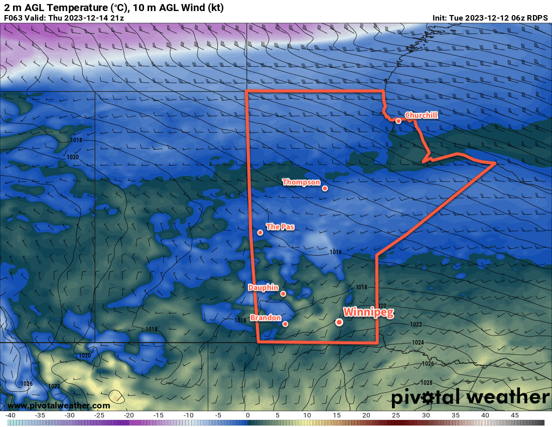
Mild temperatures will spread back across southern Manitoba by Thursday.
There will be one more day of near-seasonal temperatures in Winnipeg before warmer weather arrives. For today, a ridge of high pressure moving across the region will bring partly cloudy skies with a high around -6 °C. Temperatures will dip back down to around -10 °C tonight with clear skies.
Heading into mid-week, southerly winds will pick up across the region; winds on Wednesday will increase into the 30 to 40 km/h range with a daytime high in the -3 to 0 °C range. Temperatures will stay fairly steady on Wednesday night, followed by a high a couple degrees above freezing on Thursday. The southerly winds will finally taper off on Thursday evening.
Winnipeg will see sunny to mixed skies through this time. On Thursday night, more cloud is likely along with a chance of flurries as a disturbance moves through the region.
Long Range Outlook
Temperatures will stay mild through the weekend with highs near freezing and lows close to -10 °C. Next week, temperatures look to trend back towards seasonal values with no notable snowfall on the horizon.
Today’s seasonal daytime high in Winnipeg is -9 °C while the seasonal overnight low is -19 °C.
A low pressure system moving through the province will bring snow, falling temperatures, and strong winds to the Winnipeg area later today.
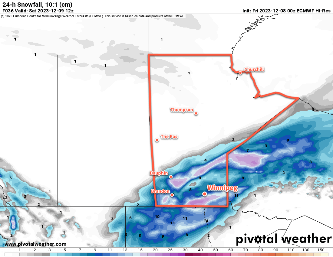
While as much as 10 to 15 cm of snow is possible later today in the Red River Valley, melting during the early parts of the event should reduce the snow accumulation into the 5 to 10 cm range for most places.
Today will be another mild day as Winnipeg finds itself in the warm sector of an approaching low pressure system. Skies will be cloudy today with a chance of a rain shower or drizzle mas temperatures climb above freezing midday. Later this afternoon, snow will begin to push across the Red River Valley as the low tracks to the east. Temperatures will dip just below freezing and the snow will likely start to pile up by late in the afternoon.
The evening will bring more snow and increasing northerly winds. Northerly winds will reach 30 gusting 50 by this afternoon, then strengthen to 50 gusting 70 km/h in the evening. Coupled with the snow and falling temperatures, it will make for poor travel conditions on area roads. Snow will pile up, surfaces will begin to freeze, and areas of blowing snow will reduce visibilities further.
The snow will taper off overnight, leaving behind about 5 to 10 cm accumulation. Temperatures will dip to a low in the -5 to -10 °C range.
The clouds will begin to break up on Saturday, bringing a bit of sun back to the region. The northerly wind will ease through the day, from 40 gusting 60 km/h in the morning to calm by evening. Although it will be a cooler day, a high near -6 °C will still be warmer than the seasonal average.
Temperatures will dip down into the -10 to -15 °C range on Saturday night with partly cloudy skies.
Sunday will bring mixed skies to the region again with a seasonal daytime high around -8 °C.
Long Range Outlook
Heading into next week, another upper ridge will build over the west coast and spread eastwards, bringing another wave of Pacific air into the Prairies. This will warm temperatures up, but exactly how much will depend significantly on the snowpack. At this point in the year, with a very shallow sun angle, a solid snowpack could more or less isolate the surface from the warmer air above.
We’ll have to wait and see…but the push of milder air does look like it will likely last well into the second half of the week. It’s hard to believe that temperatures will be able to climb too much if the entire Red River Valley ends up filled with snow in December, but stranger things have happened.
Either way, just a couple weeks out from the shortest day of the year and there are still no -30s in the Winnipeg forecast.
Today’s seasonal daytime high in Winnipeg is -9 °C while the seasonal overnight low is -18 °C.
December will start with a continuation of the mild weather the region has seen through much of the second half of November. With variable cloudiness in the days ahead, Winnipeg’s highs will keep hovering close to 0 °C.
Mild weather will once again spread eastwards into southern Manitoba for the weekend.
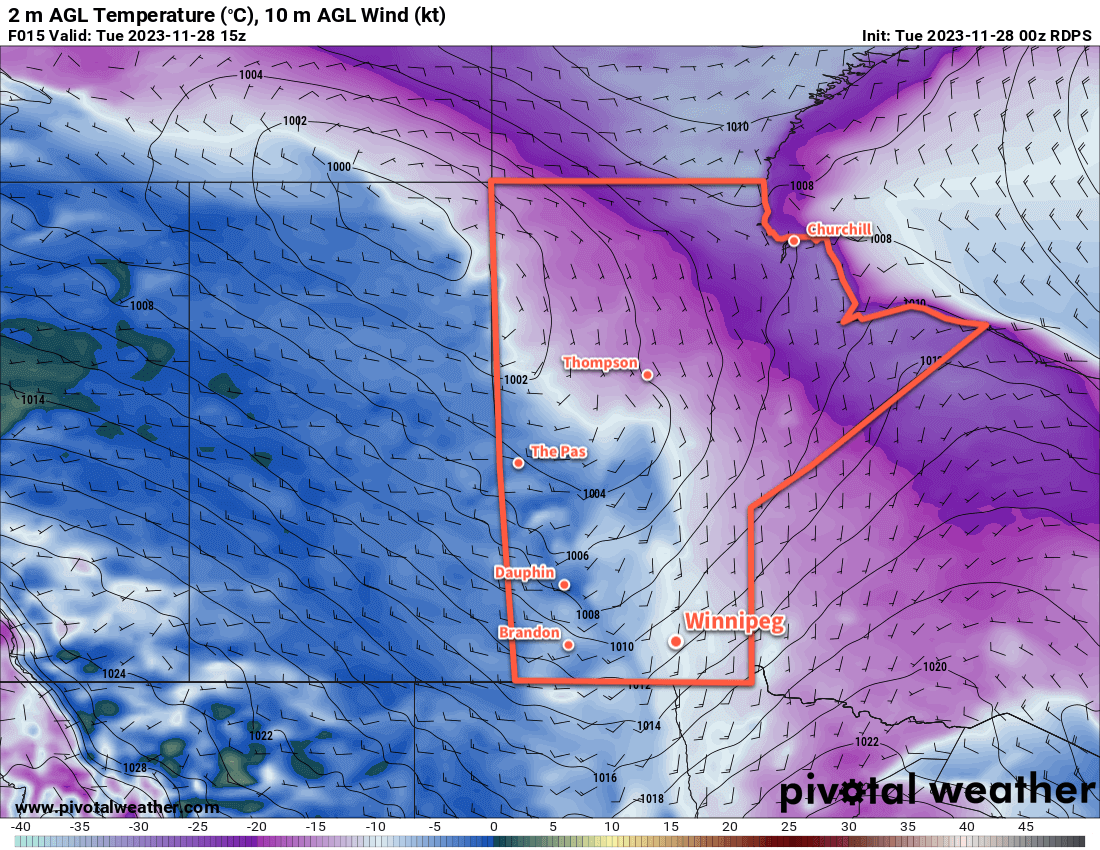
Today will start off with plenty of lingering cloud across the region; it’s part of a band that stretches from southern Manitoba northwest through Saskatchewan and marks roughly the position of the Arctic front draped through the Prairies. Skies will clear a bit later today as the front lifts to the northeast, leaving behind sunshine and light southwesterly winds as temperatures climb to around 0 °C.
Over the next few days, the region can expect variable cloudiness as milder Pacific air gradually pushes through the region. Daytime highs will hover close to freezing, perhaps a degree or two above, and overnight lows will sit in the -5 to -10 °C range. It’s unlikely that any snow or rain will fall in the city this weekend.
Saturday will be windier with southerlies up to around 30 km/h. Otherwise winds should stay light over the coming days.
Long Range Outlook
Next week will bring more mild weather as an upper ridge builds across the Prairies. Daytime highs in Winnipeg will vary from just below freezing to several degrees above. A sunnier start to the week will likely become cloudier as the warmer air moves into the region.
No notable precipitation is on the horizon. By the end of next week, the upper ridge should begin to collapse which could bring some snow to the Red River Valley to end the week.
Today’s seasonal daytime high in Winnipeg is -7 °C while the seasonal overnight low is -15 °C.
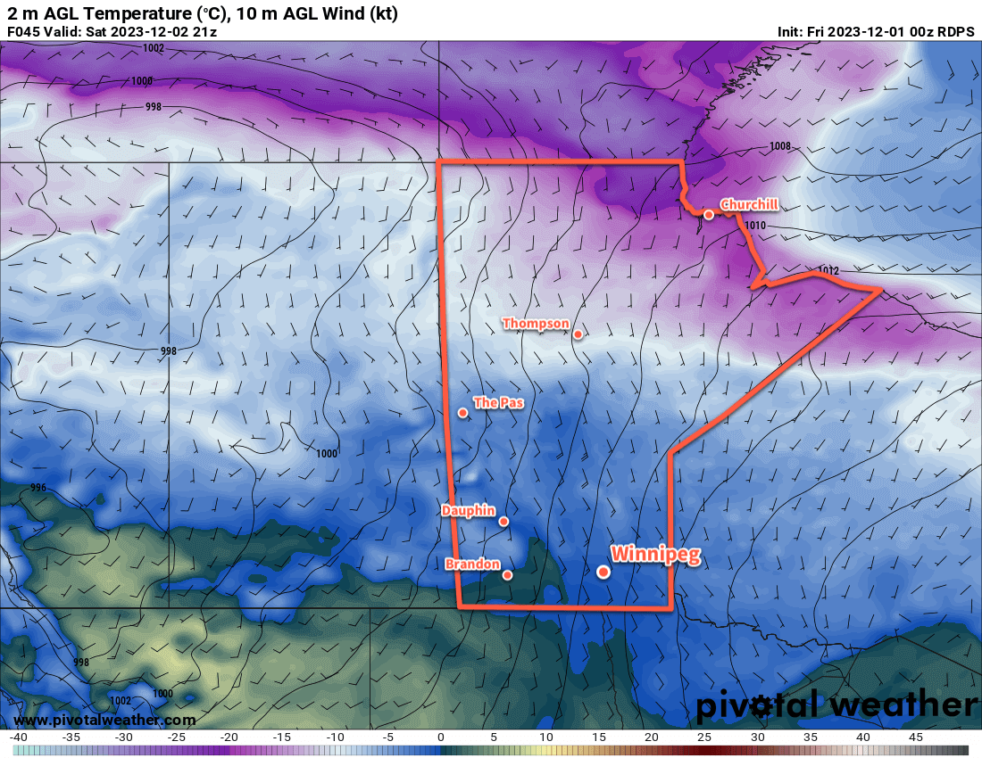
After just a couple cool days, Pacific warmth will surge across southern Manitoba today and bring milder weather back to the region.
A a warm front will push eastwards across southern Manitoba on Tuesday morning.
Residents of the Red RIver Valley will wake to breezy southerly winds this morning as a warm front quickly pushes towards the region. Wind chill values in the morning will reach into the mid-minus 20s, but that cold will be short-lived. There will be a chance of some light snow in the cloud cover ahead of the front, but little more than a dusting is expected given the dryness of the air in the southerly return flow.
The front will pass through the region midday; behind it winds will shift westerly and temperatures will rise dramatically; afternoon highs across the Red River Valley will climb to around 0 °C with many areas climbing a degree or two above freezing along and west of the Red River.
As the warm air floods east, another change is happening in the Arctic that will also have an impact on the weather in southern Manitoba. Over the next few days, a low pressure system over Québec will lift northwards and then retrograde westwards into Foxe Basin; as it does, the broader vortex its rotating around will begin to drop southwards. This will allow a subsequent Atlantic low to pull westwards through Baffin Island and into Canada’s northern areas as well. This will flood the Arctic with milder Atlantic air and erode the store of cold air in the region.
This is notable because as the weather pattern erodes over Manitoba through the weekend, the northerly winds will be tapping into cooling Atlantic air rather than bitterly cold Arctic air. This will help keep warmer air around as a northerly component to the flow won’t suddenly usher temperatures of -20 °C southwards.
The end result will be a prolonged period of seasonably mild temperatures for Winnipeg and other areas in southern Manitoba. Daytime highs will hover in the -5 to 0 °C range, or even a bit warmer, through much of the week while overnight hover in the -5 to -10 °C range. Depending on exact daytime highs, the region could also see an erosion of the limited snow cover put down by Saturday night’s brief snowfall.
Long Range Outlook
Near-seasonal or seasonably mild temeperatures and dry weather looks to continue well into next week with little change expected through the first half. If anything, long-range forecast show that after a brief cool-down to near-seasonal temperatures at the end of this week, daytime highs might pop back up to around freezing to start next week.
So far, a notably mild November that will certainly help winter feel not quite so long this year!
Today’s seasonal daytime high in Winnipeg is -6 °C while the seasonal overnight low is -14 °C.