A low pressure system moving through the province will bring snow, falling temperatures, and strong winds to the Winnipeg area later today.
Today will be another mild day as Winnipeg finds itself in the warm sector of an approaching low pressure system. Skies will be cloudy today with a chance of a rain shower or drizzle mas temperatures climb above freezing midday. Later this afternoon, snow will begin to push across the Red River Valley as the low tracks to the east. Temperatures will dip just below freezing and the snow will likely start to pile up by late in the afternoon.
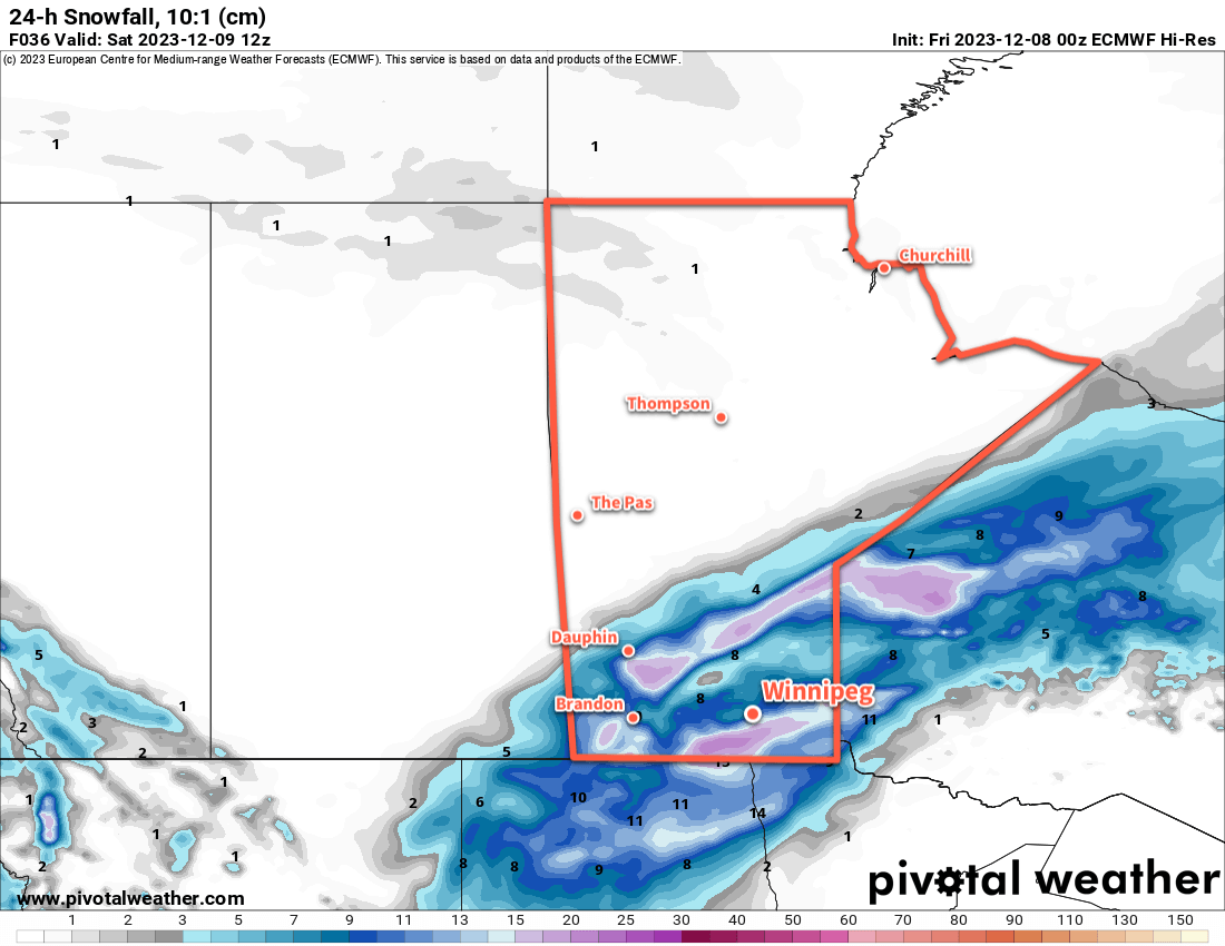
The evening will bring more snow and increasing northerly winds. Northerly winds will reach 30 gusting 50 by this afternoon, then strengthen to 50 gusting 70 km/h in the evening. Coupled with the snow and falling temperatures, it will make for poor travel conditions on area roads. Snow will pile up, surfaces will begin to freeze, and areas of blowing snow will reduce visibilities further.
The snow will taper off overnight, leaving behind about 5 to 10 cm accumulation. Temperatures will dip to a low in the -5 to -10 °C range.
The clouds will begin to break up on Saturday, bringing a bit of sun back to the region. The northerly wind will ease through the day, from 40 gusting 60 km/h in the morning to calm by evening. Although it will be a cooler day, a high near -6 °C will still be warmer than the seasonal average.
Temperatures will dip down into the -10 to -15 °C range on Saturday night with partly cloudy skies.
Sunday will bring mixed skies to the region again with a seasonal daytime high around -8 °C.
Long Range Outlook
Heading into next week, another upper ridge will build over the west coast and spread eastwards, bringing another wave of Pacific air into the Prairies. This will warm temperatures up, but exactly how much will depend significantly on the snowpack. At this point in the year, with a very shallow sun angle, a solid snowpack could more or less isolate the surface from the warmer air above.
We’ll have to wait and see…but the push of milder air does look like it will likely last well into the second half of the week. It’s hard to believe that temperatures will be able to climb too much if the entire Red River Valley ends up filled with snow in December, but stranger things have happened.
Either way, just a couple weeks out from the shortest day of the year and there are still no -30s in the Winnipeg forecast.
Today’s seasonal daytime high in Winnipeg is -9 °C while the seasonal overnight low is -18 °C.