Temperature Roller Coaster Ahead

Temperatures will be taking a ride on a roller coaster this week as abnormally warm weather briefly gives way to a more seasonal cold snap and then soars back to well above-normal conditions. By the latter half of the week, above-0°C daytime highs may even be possible.

A mild air mass over the Red River Valley will bring a typical "warmer than it ought to be this time of year" mix of conditions to the region. It will be mainly cloudy today with a chance of flurries throughout much of the day, although if any snow does materialize, it should be light. Throughout the morning hours, though, fog patches and the risk of freezing drizzle will be the more prominent weather. The temperature should climb to around -1°C for a daytime high with light winds.

RDPS Forecast 2m Temperatures valid 21Z Monday February 15, 2016
The RDPS is forecasting temperatures just below freezing across Southern Manitoba today.

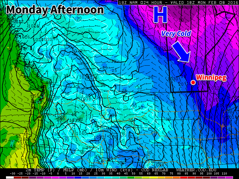
Light northerly winds will develop this evening, ushering in cooler air. As the cloud cover gradually scatters out, temperatures will drop to an overnight low near -18°C. The light northerly winds will continue through Tuesday courtesy of an Arctic ridge building into the region. Temperatures will rebound to a high of about -13°C under partly cloudy skies, and then drop into the minus twenties for an overnight low near -22°C.

Tuesday night will be the coldest night for a while as a significant pattern change begins on Wednesday which will result in a more persistent flow of Pacific air across the Prairies. The result will be a second half of the week that brings daytime highs well above normal. For Wednesday, a warm front will push across the Red River Valley, bringing southerly winds of 20-30 km/h and temperatures climbing to about -7°C. The warm weather will continue to push in on Wednesday night with temperatures climbing a couple degrees more. With that warmer weather moving in, there will also be a chance of some flurries, but no significant accumulations are expected.

Long Range: Warm!

The second half of the week will be mild, albeit cloudy, as significantly warmer air moves in from the west.

GDPS Forecast 850mb Temperature Anomalies valid 12Z Friday February 19, 2016
The GDPS is forecasting 850mb temperatures to be around 20°C above normal on Friday.

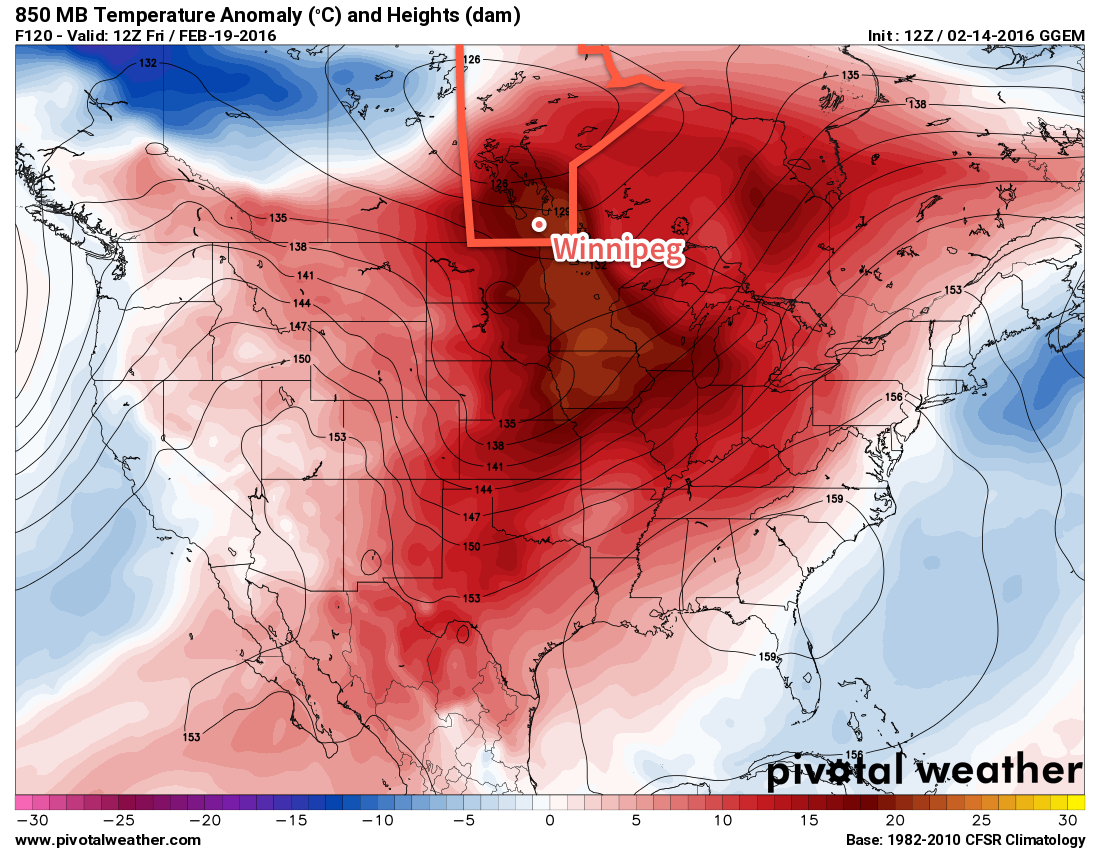
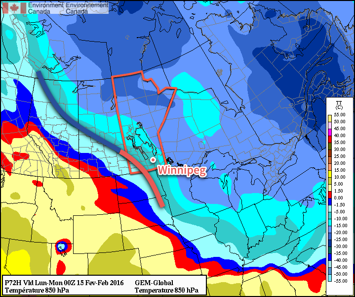
This surge of warm air is well represented by the forecast 850mb temperatures heading into Friday. As shown above, a surge of warm air around 20°C above normal is forecast to move into the region. The temperatures at this level don’t correspond 1:1 with surface temperatures, so don’t expect it to be 20°C above normal (which would be a high of +12°C) on Friday. Rather, what we’ll see is temperatures getting about as warm as they’re allowed to get with the established snowpack we have, and they likely won’t budge too much once they get there, at least until the warm air leaves.

Temperatures will likely climb to +1 or +2°C on Thursday with a chance of some light snow. Once we reach that high temperature, temperatures will likely remain there until a weak cold front moves through on Friday night. It looks a bit uncertain at this point, but there will be the chance for precipitation throughout both Thursday and Friday.

Heading into the weekend, it will be cooler but still above normal with daytime highs in the minus mid-single digits. There will be the occasional chance for some flurry activity.

The normal daytime high for Winnipeg is currently -8°C and the normal overnight low is -18°C.

Mild Weather Returns for End of Weekend

Bitterly cold temperatures will be in place today as a strong Arctic ridge of high pressure moves through the region. This cold snap will be short-lived as warmer air begins moving into the region through the weekend; by Sunday, milder temperatures will be in place alongside some light snow.

Today will be, temperature-wise, the coldest day of the week as temperatures are held back by the breezy northwesterly winds of an advancing Arctic air mass. Temperatures will recover only a little bit as they struggle to climb to an afternoon high near -21°C before quickly beginning to drop as the sun goes down this evening.

Environment Canada's extreme cold warning issued Thursday afternoon.
Environment Canada’s extreme cold warning issued Thursday afternoon.

Temperatures will plummet to the -30°C mark by Saturday morning as winds gradually diminish. Wind chills this morning as well as tonight will likely be flirting closely with the -40 mark. Environment Canada has issued an extreme cold warning for much of the province because of that.

Saturday may end up feeling like a colder day than Friday; while warmer temperatures may begin to work into the region, they’ll be accompanied by those famous winter southerlies that result in a fairly miserable transition day to warmer weather. While temperatures will rise towards -15°C by the end of the day, southerly winds will strengthen to around 40km/h making it feel significantly colder than it actually is. As a warm front begins moving into Manitoba later in the day, it will spread cloud cover into the Red River Valley and by mid-evening, it seems likely that skies will be mixed to cloudy with a chance of flurries. It will stay fairly windy through the night as temperatures continue to rise to around -12°C by Sunday morning.

GDPS 850mb temperature forecast valid Sunday evening
A frontal wave will pass through Manitoba on Sunday brininging warmer weather and light snow.

Sunday will be significantly more pleasant as mild weather continues to move into the region. Temperatures will climb to near -6°C on Sunday afternoon with light winds and a good chance of light snow. No significant accumulations are expected with Sunday’s disturbance, although 1-2cm of snow could pile up locally. Temperatures will fall to just -9 or -10°C on Sunday night under cloudy skies.

Long Range: Generally Mild

Looking ahead into next week, it looks like Southern Manitoba is transitioning into a generally above-normal temperature pattern.

CPC 6-10 Day Temperature Anomaly Forecast
The CPC is calling for above normal temperatures in the 6-10 day timeframe.

Milder Pacific air will be building into the province through much of next week. The start of next week will see a bit more variability in temperatures, with some days above normal and some below, but by the second half of the week there seems to be a fair amount of confidence of temperatures switching to a more persistent above-normal pattern. Current guidance places daytime highs near -5°C by the end of next week into the week after.

Through this period, no significant precipitation events are expected.

The normal daytime high for Winnipeg is currently -9°C and the normal overnight low is -19°C.

Flurries Bring More Cold Weather

A disturbance passing through southwestern Manitoba today will spread a few flurries into the Red River Valley through the day today, while snow giving accumulations remains to our west where a further 2-4 cm of snow is expected to fall. Another blast of Arctic air will plunge southwards behind this system, plunging temperatures 10-15°C below normal by the end of the week.

A few flurries will be in place throughout Winnipeg and the Red River Valley today as a low pressure system passes through southwestern Manitoba. West of the Valley, through Parkland & southwest Manitoba, the snowfall will be more organized, with between 2 to 4 cm piling up by the end of the day.

Amounts diminish quickly to the east, however, with only a dusting in the Red River Valley. The flurries will taper off by the evening, leaving us with mostly cloudy skies.

Temperature wise, today will be the best day of the week. Daytime highs should climb to around -14°C in Winnipeg today with winds out of the southeast between 10-20 km/h. Temperatures will be cool tonight, but the cloud cover will help moderate things ever so slightly. The overnight low in Winnipeg will fall to near -23°C with light northwesterly winds.

The story for the remainder of the work week is simple: Arctic air building in. Behind Wednesday’s low, an Arctic ridge will build southeastwards, ushering in colder air that will result in temperatures near 10°C below normal by Friday.

GDPS 850mb Temperature Anomaly valid 18Z Friday February 12, 2016
The GDPS is showing 850mb temperatures nearly 10°C below normal for Winnipeg on Friday.

Thursday will be fairly cloudy as we remain relatively close to a strong frontal boundary to our west. As a result, temperatures will be similar to Wednesday but just a degree or two colder. That means in Winnipeg I expect to see a high near -15°C with winds remaining fairly light out of the west to northwest. Some cloud will begin breaking up on Thursday night as the ridge begins pushing into the southern Prairies, and the overnight low will dip to around -25 or -26°C under light northerly winds.

Friday will see clearing as the Arctic ridge moves over Southern Manitoba. This will be the coldest day of the week with high temperatures struggling to climb above -20°C. Friday night will be the coldest night of the week, with temperatures dipping precariously close to the -30°C mark, if not below it. Throughout the whole time, winds will remain light.

Long Range: Big-Time Warm-Up In The Cards?

While the cold weather will likely persist into the weekend, all signs point towards a dramatic warm-up for the beginning of next week and potentially persisting well through the week.

The first of several Pacific-sourced systems is expected to track across the Prairies on Monday, spreading warmer air eastwards as the Polar Vortex begins shifting eastwards. This system is forecast to be followed up by a much, much stronger system that is showing the potential of bringing significant amounts of warm air to the eastern Prairies. The potential for daytime highs above 0°C returns for the second half of next week.

Of course, along with any big warm-up, the potential exists for some particularly uncomfortable days with strong southerly winds and it’s currently unclear on where exactly precipitation associated with these systems will fall. More on that later this week!

The normal daytime high for Winnipeg is currently -9°C and the normal overnight low is -20°C.

Colder This Week

This week will be see temperatures trend below seasonal as a surge of arctic air comes down from the north.

Colder weather is expected this week behind the weekend's departing low pressure system
Colder weather is expected this week behind the weekend’s departing low pressure system

Today will be slightly below seasonal as colder air filters southward behind the weekend’s strong low pressure system. High temperatures will be in the low minus teens under clearing skies. Winds will remain stiff out of the north-west at 30km/h gusting to 50km/h. There may still be a bit of drifting snow on the highways with these wind speeds, but heavy blowing snow is not expected.

Tuesday will see a further drop in temperatures as that arctic air mass becomes more entrenched over southern Manitoba. High temperatures will be in the upper minus teens under mainly sunny skies. Winds will remain northerly at about 20km/h. Tuesday night is expected to be quite cold due to the presence of a strong surface ridge of high pressure over the area along with clear skies. Temperatures are expected to drop to around -30C, but luckily wind chill values should not be a significant factor due to the light winds with this high pressure system.

Wednesday will remain cold, with temperatures staying in the upper minus teens. The good part of this colder pattern is that we should continue to see sunny skies on Wednesday. We will be under the centre of a surface high on Wednesday, bringing generally light winds to the region.

Long Range

The long range forecast shows cold conditions sticking around for the rest of the work-week. Models suggest we should warm back up to above-seasonal conditions by the weekend into next week. In the even longer range it appears that we may see one more arctic blast later next week before a more prolonged warm period takes hold towards the end of the month.