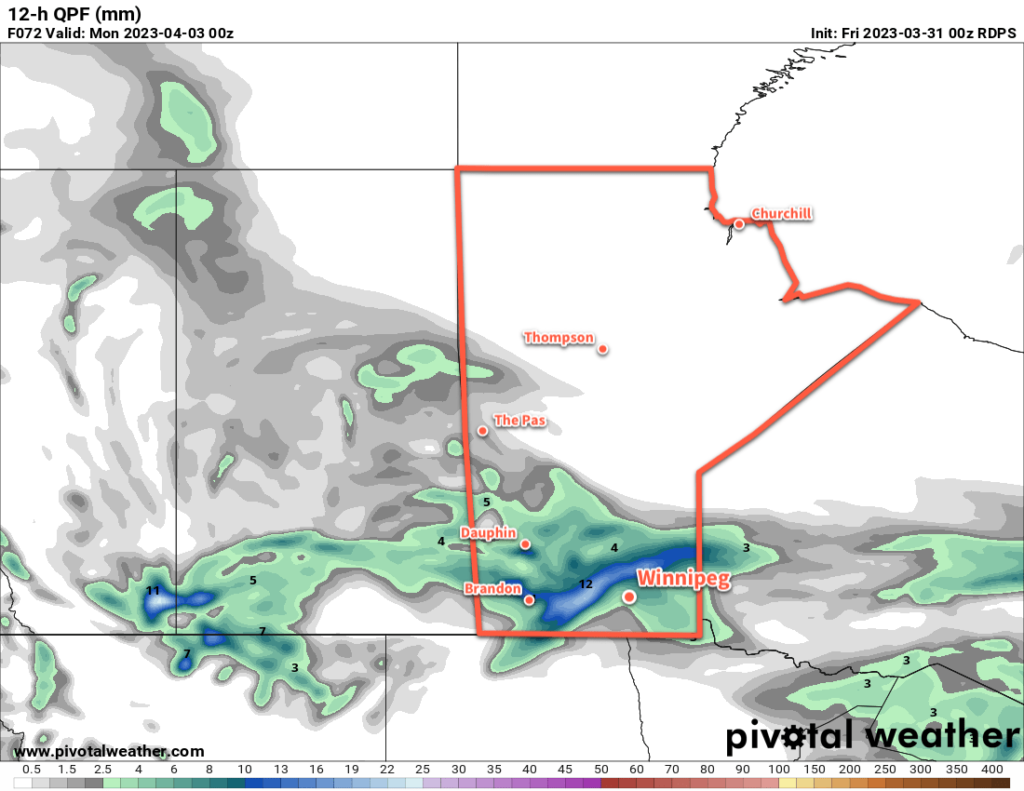
Slow-Moving Disturbance to Bring Spring Storm to Southern Manitoba

A slow-moving upper-level disturbance will bring cooler temperatures and plenty of snow to parts of southern Manitoba this week.
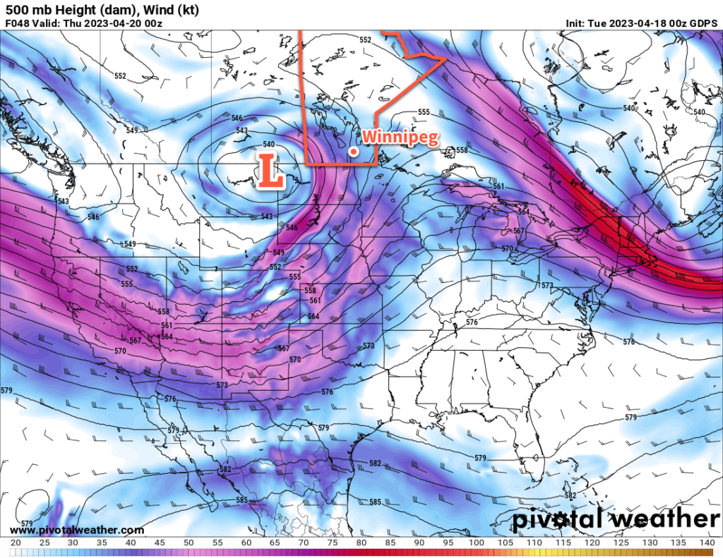
GDPS 500mb Height and Wind Forecast valid 00Z Thursday April 20, 2023
A potent, slow-moving upper low will bring a multi-day snowfall event to southern Manitoba.

Winnipeg and area will see a relatively pleasant spring day today as a ridge of high pressure continues to sit over the region. Temperatures will climb up to around the 10 °C mark this afternoon with increasing easterly winds towards evening.

A large upper-level disturbance will begin working into the region tonight. It will spread precipitation through Saskatchewan today, reaching SW Manitoba by the evening. This system may start as a wintery mix in Saskatchewan today, but will trend towards primarily a snow-maker as it moves into Manitoba.

This system will produce significant amounts of snowfall over southeast Saskatchewan into parts of SW and Parkland Manitoba. By Wednesday morning, 5–10 cm of snow will have likely fallen across those regions with another 10–20 cm through the day Wednesday. On Wednesday night, another 5–10 cm will fall across those areas, with higher possible along the escarpment west of Lake Manitoba and Lake Winnipegosis. The snow will gradually come to an end in those areas on Thursday, with accumulations ranging from a couple centimetres to as much as another 5–10 cm.

Further east in Winnipeg and much of the Red River Valley, snow should push through the area in multiple waves. Some light snow or rain showers are possible later today, but copious amounts of dry air near the surface will likely evaporate much of that activity before it reaches the ground.

The first organized wave of snow will push into the region on Wednesday morning, moving northwards through the day. This will drop 2–5 cm across much of the Red River Valley on Wednesday, though amounts may increase quickly close to the western escarpment. Some periods of light snow are possible on Thursday, though much of the organized activity will likely remain to the west.

A more organized band of accumulating snow will push towards Winnipeg on Thursday evening as another wave of moisture wraps into the system impacting the area. This could bring Winnipeg’s heaviest snowfall of the event with the potential of anywhere from 5 to 15 cm of snow.

Throughout this entire disturbance, moderate easterly winds will slowly shift northerly over the course of the week, and temperatures will struggle to climb only  at most to a few degrees above freezing. There is a slight chance that precipitation could briefly change over to rain, particularly for areas south of Winnipeg, if a bit of warmer air can wrap into this system at times.

Keep alert for updated watches or warnings from the Meteorological Service of Canada.

The last note for this system is that in many areas, snow will fall with temperatures close to 0 °C. As a result, some may melt and much of the snow will be relatively heavy and prone to compaction. This may make measurable snow on the ground at the end of the event less than what actually fell.

Long Range Outlook

This system will finally begin to clear out of the region on Friday, followed by a couple days of seasonably cool temperatures.

A return to seasonal warmth with highs in the low teens should build into the region early next week.

Today’s seasonal daytime high in Winnipeg is 11 °C while the seasonal overnight low is -1 °C.
Weekend Brings Start to Spring Melt

A strong upper ridge will spread a much warmer air mass into the eastern Prairies this weekend, marking the start of a widespread spring melt.

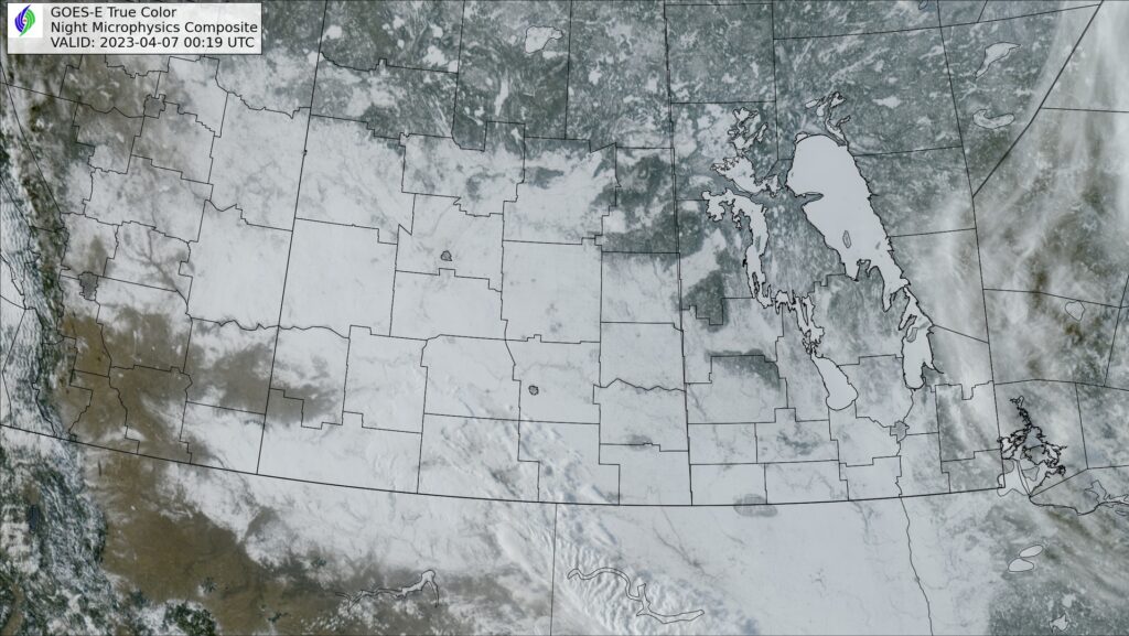
GOES-16 True Colour RGB Image of the Southern Prairies valid 0019Z Friday April 7, 2023
True-colour satellite imagery from Thursday evening reveals a widespread snowpack (white) across much of southern Saskatchewan, southern Manitoba, and North Dakota.

As we mentioned on Tuesday, southern Manitoba will see a much warmer air mass move into the region this weekend as upper ridging persists over western Canada. While this feature will produce plenty of warm air that will head east, the biggest wrinkle in the whole thing is the extensive snow pack across southern Manitoba and North Dakota.

This deep layer of snow will keep the surface cooler and help support an inversion across the region. An inversion is when temperature warms as you go up instead of cooling. This can effectively limit the ability for the warmer air over top of the surface to reach down to the ground.

Mild air will certainly stream into the province this weekend. Temperatures at 850 mb — about 1.5 km above the ground — will climb from around 0 °C on Saturday to warmer than 15 °C on Tuesday into Wednesday. Now, if we had full sunshine and dry, bare ground, that could result in daytime highs climbing from the low teens into the upper 20s. But the snow will absolutely keep temperatures much cooler than that.

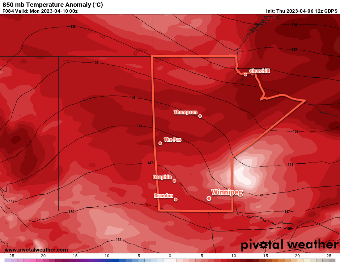
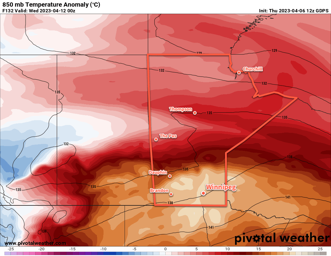
850mb temperature anomalies — how much warmer or colder than the seasonal average values — show the entire Prairies seeing a seasonably mild air mass by the end of the weekend (left image). Heading into next week, though, the air mass becomes unseasonably warm over the southeastern Prairies (right image). How this abnormal warmth will interact with the existing snowpack is unclear at this time.

The other factor to pay attention to that will dramatically impact how quickly the snow melts will be the dew point temperature. When the dew point is below freezing, it is easy for water that is draining through the snowpack to re-freeze within it. But when the dew point climbs above freezing, that process becomes much harder and the rate the snow pack will melt at increases. The dew point will likely climb to the positive side of freezing this weekend, then increase several degrees above freezing next week as the warmer air pushes into the region.

The last factor to take into account is what all this water that’s melting out of the snow will do. With warming temperatures aloft and a strong inversion, that moisture will be trapped near the surface. This could result in the development of fog and low clouds as the melt picks up, which would also work to reduce potential high temperatures and produce cloudier conditions that really lock temperatures fairly close to freezing. It’s simply impossible to tell at this time if that will happen this weekend, but it’s a possibility to keep in mind.

So all that said, what can we expect?

After a cold start to the morning, temperatures will climb to a high near freezing this afternoon with a light southerly wind. Temperatures will dip back down into the minus teens tonight, the the warmer air mass begins building in this weekend.

Temperatures will climb to a high a few degrees above freezing on Saturday and Sunday with light southerly winds continuing. Overnight lows will be much warmer, just dipping below freezing overnight on both nights. Conditions will likely be sunny, but particularly beginning Saturday night there may be a chance of seeing widespread fog or low cloud develop. If it does, it could persist through Sunday and into the start of next week.

The snowpack will likely begin to melt at a faster rate as dew point values climb above freezing on the weekend.

Long Range Outlook

Next week will start off with a very warm air mass moving over the region, with the large question mark of how the near-surface layer will interact with the snowpack. Continued southerly winds will likely serve to reinforce the low-level inversion, but the sheer magnitude of the warm air will likely result in either (a) temperatures climbing towards 10 °C or even warmer in any areas with an eroded snow pack, or (b) widespread development of low cloud that results in near-surface temperatures again only a few degrees above freezing.

It’s simply too early to know exactly how that will go at this point, but we’ll be keeping an eye on things through the weekend.

One thing for sure is that substantial amounts of snow will melt next week, both in southern Manitoba as well as North Dakota. The water may appear relatively quickly, so we encourage anybody in areas that may need to be concerned about flooding to keep a close eye on updated flood conditions and forecasts. Moderate to major flooding is possible along parts of the Red River in North Dakota and Manitoba. Depending on the rate of snowpack melt in Manitoba, overland flooding may also be an issue beginning next week.

Fortunately, there is little risk for any notable precipitation across southern Manitoba over the coming week.

Today’s seasonal daytime high in Winnipeg is 7 °C while the seasonal overnight low is -4 °C.

Spring Storm to be Followed by Much Warmer Weather

A Colorado Low is on the way to Southern Manitoba and will bring snow and blowing snow to the region beginning Tuesday night. This storm will exit the region on Thursday, and after a couple cool days much warmer spring weather will move into the province.

Weather alert map valid 0827Z Tuesday April 4, 2023
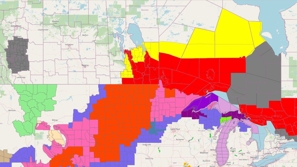
Winter storm warnings are out across southern Manitoba (red on the Canadian side of the border) with blizzard warnings across much of the Northern Plains of the United States (red south of the international border) for a potent spring storm moving into the region. Image valid at 8:30 AM Tuesday March 4, 2023.

A Colorado Low is organizing south of the border that will bring a blast of winter weather to parts of southern Manitoba. It has already begun to spread a band of snow through South Dakota that will lift north-northeast through the day today.

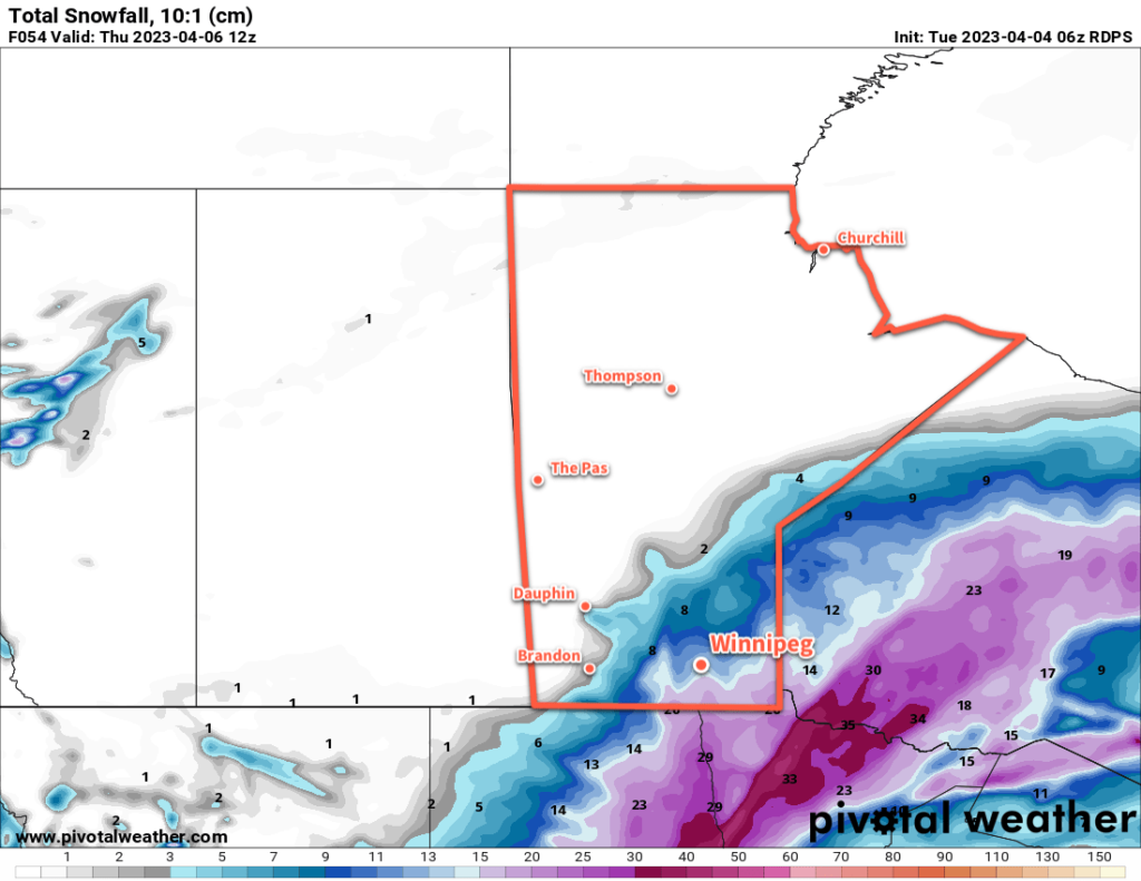
In Southern Manitoba, the snow will approach the southern border by evening, then spread into the province overnight. Light snow will fall across southwest Manitoba, with heavier snow pushing into the Red River Valley and southeastern corner of the province. The Trans-Canada Highway corridor in the RRV will likely receive 5–10 cm of snow by Wednesday morning with higher amounts of 10–20 cm to the south and southeast.

Snow will continue across the Red River Valley and east on Wednesday with another 5 to 10 cm likely in most regions. The snow will finally begin to taper off on Wednesday night. By the time all is said and done, much of southern Manitoba will receive 15 to 25 cm of snow; amounts will drop off quickly west and north of a line running roughly from Pilot Mound to Berens River. The heaviest amounts could reach into the 30 to 40 cm range with the highest risk for that much snow focused in two locations: Sprague and the southwest Red River Valley, particularly in the areas closer to the western escarpment.

RDPS Total Accumulated Snowfall Forecast (10:1 SLR) valid 12Z Thursday April 6, 2023
Much of southern Manitoba will see notable snowfall accumulation as the region is clipped by a Colorado Low Tuesday night through Wednesday.

In addition to the snow, moderate northwesterly winds will develop on Wednesday, bringing areas of blowing snow to the Red River Valley. In combination with the moderate falling snow, expect poor travel conditions across the region, including southward into the United States, Tuesday night through Thursday.

Please refer to the Meteorological Service of Canada for the latest weather alerts for Manitoba.

Temperatures will run seasonably cool through the storm with highs in the -5 to 0 °C range over the next few days. Lows will generally sit in the -5 to -10 °C range, except for Thursday night where clear skies will combine with the fresh snow to send lows into the mid-minus teens.

Long Range Outlook

Probably just as notable as all the snow coming over the next couple days will be the forecast for the weekend. As the Colorado Low pushes northwards, it will dislodge the Polar Vortex and send it further north, finally loosening its influence over the eastern Prairies. A more zonal flow aloft will develop over the region, and much warmer Pacific air will begin to sweep across the Prairies this weekend.

The extensive snow pack over the region will limit daytime highs into the low to mid-single digits. If the ground were completely bare and skies were sunny, daytime highs in the mid-teens could be possible Sunday into Monday; alas. But in addition to temperatures climbing above freezing, this push of warm air will also likely send dew point values above 0 °C as well.

Dew point values rising above freezing greatly enhance how quickly snow can melt, and although the warmer weather will be welcome, it may result in a lot of melting from Saturday through Wednesday. Given the pre-existing concern in Manitoba’s flood forecast, this could result in a higher flood risk for some areas. Be sure to watch for updated Manitoba Flood Forecasts and Reports if you are concerned that you may be impacted by a quick melt.

Today’s seasonal daytime high in Winnipeg is 7 °C while the seasonal overnight low is -4 °C.

Warmer Weather Returns, but Unsettled Conditions Ahead

Winnipeg will finally see temperatures returning towards seasonal values, but after a couple more nice days the weather will turn more unsettled.

RDPS Precipitation Type & Intensity Forecast valid 00Z Monday March 3, 2023
Southern Manitoba will see more snow on Sunday as a compact but intense low pressure system moves through.

It will be seasonably cool in Winnipeg over the next couple days as daytime highs climb to around the freezing mark under sunny skies. A broad area of high pressure over the province will keep the main weather track to the south, leaving cool but pleasant conditions across southern Manitoba.

Overnight lows will be cool tonight as clear skies combine with the widespread snowpack still in place over the region. Most areas will see temperatures dip down  into the -15 to -20 °C by early Saturday morning. Overnight lows will be very different on Saturday night as cloud cover associated with an approaching warm front moves in. Most areas will see temperatures stay steady in the 0 to -5 °C range.

On Sunday, a low pressure system will track across southern Manitoba, bringing mainly snow to the region, though a wintery mix may be possible in some parts of southern Manitoba. Accumulations are tricky to forecast at this point; this system will be compact and relatively energetic, likely with some convective elements embedded within it. On the cold side of this system’s fronts, snowfall amounts of 5–10 cm are possible, perhaps even higher if this system has enough instability. On the warm side, temperatures could end up climbing a degree or two above freezing, and melting will impact the accumulations.

All that means that what any one place sees on Sunday will depend significantly on the exact track of the system and how intense the low ends up being. Almost certainly many places will see poor conditions on Sunday with some accumulation of snow and possibly rain, but we’ll need to wait a bit longer to see exactly how this system shapes up to know exactly what it will bring.

Long Range Outlook

The weather will settle down for a couple days to start next week, though a fair amount of cloud will linger in the region. Temperatures will again stay seasonably cool with light northerly winds.

The next disturbance that could impact our region is a potent Colorado Low expected to eject northeastwards mid-week. There’s a significant amount of uncertainty as to how far north this system will push, but there is a chance that southern Manitoba will be grazed by the northwestern flank of the system. This could bring light to moderate snow into the province along with cool temperatures and moderate to strong northerly winds possibly beginning Tuesday night into Wednesday.

We’ll be keeping an eye on this system as it develops and have an update in next week’s forecast.

Otherwise, it’s reasonable to expect seasonally cool temperatures as the snow pack remains over the region, with cooler lows on clear nights. We should begin to see a more sustained warmup after next week as heading into April the sun begins to get noticeably stronger and warmer conditions continue to push northwards through the United States.

Today’s seasonal daytime high in Winnipeg is 5 °C while the seasonal overnight low is -6 °C.