A Colorado Low is on the way to Southern Manitoba and will bring snow and blowing snow to the region beginning Tuesday night. This storm will exit the region on Thursday, and after a couple cool days much warmer spring weather will move into the province.
A Colorado Low is organizing south of the border that will bring a blast of winter weather to parts of southern Manitoba. It has already begun to spread a band of snow through South Dakota that will lift north-northeast through the day today.
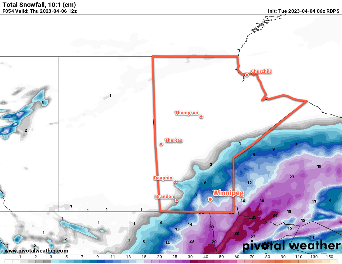
In Southern Manitoba, the snow will approach the southern border by evening, then spread into the province overnight. Light snow will fall across southwest Manitoba, with heavier snow pushing into the Red River Valley and southeastern corner of the province. The Trans-Canada Highway corridor in the RRV will likely receive 5–10 cm of snow by Wednesday morning with higher amounts of 10–20 cm to the south and southeast.
Snow will continue across the Red River Valley and east on Wednesday with another 5 to 10 cm likely in most regions. The snow will finally begin to taper off on Wednesday night. By the time all is said and done, much of southern Manitoba will receive 15 to 25 cm of snow; amounts will drop off quickly west and north of a line running roughly from Pilot Mound to Berens River. The heaviest amounts could reach into the 30 to 40 cm range with the highest risk for that much snow focused in two locations: Sprague and the southwest Red River Valley, particularly in the areas closer to the western escarpment.
In addition to the snow, moderate northwesterly winds will develop on Wednesday, bringing areas of blowing snow to the Red River Valley. In combination with the moderate falling snow, expect poor travel conditions across the region, including southward into the United States, Tuesday night through Thursday.
Please refer to the Meteorological Service of Canada for the latest weather alerts for Manitoba.
Temperatures will run seasonably cool through the storm with highs in the -5 to 0 °C range over the next few days. Lows will generally sit in the -5 to -10 °C range, except for Thursday night where clear skies will combine with the fresh snow to send lows into the mid-minus teens.
Long Range Outlook
Probably just as notable as all the snow coming over the next couple days will be the forecast for the weekend. As the Colorado Low pushes northwards, it will dislodge the Polar Vortex and send it further north, finally loosening its influence over the eastern Prairies. A more zonal flow aloft will develop over the region, and much warmer Pacific air will begin to sweep across the Prairies this weekend.
The extensive snow pack over the region will limit daytime highs into the low to mid-single digits. If the ground were completely bare and skies were sunny, daytime highs in the mid-teens could be possible Sunday into Monday; alas. But in addition to temperatures climbing above freezing, this push of warm air will also likely send dew point values above 0 °C as well.
Dew point values rising above freezing greatly enhance how quickly snow can melt, and although the warmer weather will be welcome, it may result in a lot of melting from Saturday through Wednesday. Given the pre-existing concern in Manitoba’s flood forecast, this could result in a higher flood risk for some areas. Be sure to watch for updated Manitoba Flood Forecasts and Reports if you are concerned that you may be impacted by a quick melt.
Today’s seasonal daytime high in Winnipeg is 7 °C while the seasonal overnight low is -4 °C.
Thank you for all your hard work, I am really enjoying this blog and your manner of writing.
Greetings from Charleswood.
I’m glad you like it! Thanks for reading.