Winnipeg will see a few showers this morning develop into a rainy afternoon before it all turns to wet snow this evening as the first “summer-y” system of the year pushes through Southern Manitoba.
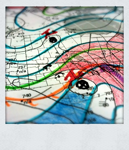
Hand-analysis of the 925mb Height/Thermal Field for 12Z March 20
A very summer-y low is passing through North Dakota this morning, with a warm front draped west-to-east across much of the state, just south of the international border, before it dives south through Iowa. This system has brought with it copious amounts of warm air and is the first real summer-like system of the year.
East of the warm front, in Iowa, a complex of thunderstorms are moving across the state, supported by a 60 kt 850mb jet riding over the surface warm front, bringing with it moist air with Θw values near 20°C. This 60 kt LLJ then arcs north and pushes into Northwestern Ontario. As can be seen by the red shading in the analysis I have done this morning, warmer air is being pushed up through much of Southern Manitoba, including the RRV, Interlake and Parkland regions of west-central Manitoba. With the surface warm front just south of the border and plenty of warm air overrunning it, this has brought a mix of precipitation for areas in Southwestern Manitoba across the Trans-Canada highway into the Whiteshell and north.

1.5km CAPPI Radar Reflectivities
Pilot Mound, Morden, Steinbach and Sprague should escape most of the precipitation until later today. Being so close to the warm front, the precipitation is actually developing north of them where the air aloft that is being lifted is saturating. For those areas, expect a cloudy day with drizzle likely and if the wind manages to calm a bit (say to 15 km/h or less) fog patches are certainly possible. By later this afternoon, rain should move into the area, though with accumulations of about 5mm. For Portage la Prairie, Winnipeg, Dugald, Selkirk/Gimli and the Whiteshell, showers seen this morning will continue to develop and intensify to an area of rain by this afternoon. Expect to see about 5-10mm of rain before switching over to wet snow this evening. Do not be surprised to see a few snowflakes today, though; as it is quite likely for there to be embedded convection in the rain bands, areas of heavier precipitation may be able to produce rain mixed with snow as the shallow warm pool is unable to completely melt all the precipitation.

12Z 20 March 2011 GEM-REG 12h QPF Accumulation valid 00Z March 21 2011
Further west, over the higher terrain, the precipitation will predominantly be snow. Dauphin/St. Rose/Minnedosa are under a heavy snowfall warning as 10-15cm of snow are expected by this evening. Fortunately, as this weather system is driven primarily by warm air, the precipitation should end quite quickly as the low pulls out of our area this evening.
All in all, it’s quite a good day to stay inside with a hot drink and read a book. A little bit of everything will be seen through the afternoon, and unless you’re a big fan of having a new “Rally Inspired” paint job on your car, it’s best to stay off the messy, messy roads.
The next significant weather system will pass through on Tuesday, and this system will receive plenty of attention as it develops as it has the potential to produce significant amounts of snow/rain, and could add uncomfortable amounts of water into the Assiniboine/Red River drainage basins. I’ll post some more information about that system on Monday when things are a little clearer.