Pleasant weather is on tap this week as we see a fair amount of sunshine and above-seasonal temperatures.
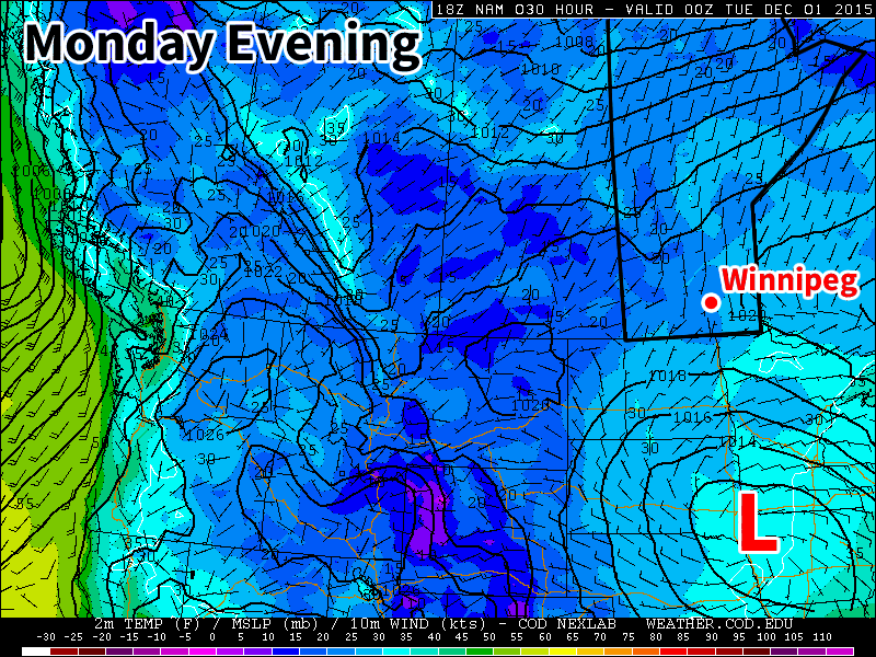
A low pressure system will sit just south of Manitoba early in the week
Monday
Today will see mainly sunny skies and mild temperatures. The daytime high will be just below zero with light southerly winds. A strong low pressure system will be bringing precipitation to portions of the Dakotas and Minnesota early this week, so you’ll want to check the forecast if you’re heading south.
Tuesday
Tuesday will see much the same weather as Monday. Skies are expected to remain mainly sunny, with high temperatures in the mid single digits. If the system to the south pushes a bit further north we may see more cloud cover, but that is not expected to be the case at this point. Winds will be north or north-westerly at 20 km/h.
Wednesday
Wednesday will once again feature mainly sunny skies and mild temperatures. Temperatures will be just below zero, with breezy southerly winds at 20 km/h.
Long Range
The long range forecast continues to strongly suggest above-normal weather for the first half of December. The current weather pattern over North America is very typical of El Nino, with warm conditions across the western half of Canada and an active storm track across the southern US. Expect this pattern to continue as we move further into winter.
With the 2015 Grey Cup taking center stage in Winnipeg on Sunday, one of the most pertinent questions fans heading to the game must be—or should be—wondering is what do you wear to an outdoor event, in Winnipeg, at the end of November? Fortunately, while you’ll still need to bundle up a little bit, the weather will be far more pleasant this year than it has been in many Novembers past.
Heading into the weekend, we’ll see a traditional “transition back towards milder weather” day. This means a day of it feeling quite a bit worse than the basic forecast might imply. Although temperatures will climb to around the –6°C mark today, it will do so with a fairly unpleasant southerly wind blowing down the Red River Valley, likely to around 35–45km/h with gusts up to the 60km/h mark by early this afternoon. This will make it rather unpleasant outside and hide any benefit the warmer temperatures have. It is, however, the unfortunate necessity of bringing warmer weather into the Red River Valley with an Arctic high pressure system to our south.
Saturday will bring seasonal temperatures with highs around –5°C and much lighter winds. The fairly sunny skies will make it an all-around nice day for the end of November. Temperatures will dip to about –10°C overnight.
For Grey Cup Sunday, it looks like temperatures will sit around the seasonal mark of –5 with increasing cloud cover through the day. For kickoff at 5PM, the temperature should be around –4 to –5°C with a light southerly wind of 10–15km/h. The temperature will gradually fall through the remainder of the evening, but should stay within the –5°C to –9°C range. The wind will also taper off as the evening progresses. No snow is expected at this point.
Long Range
For the coming week, conditions look very nice for Southern Manitoba.
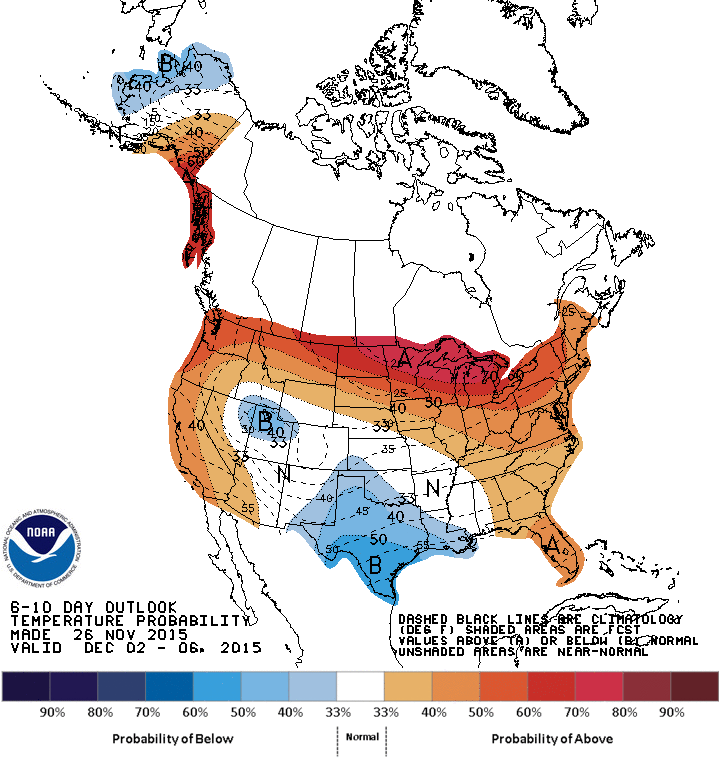
The CPC 6-10 day temperature anomaly forecast, valid for December 5 – 18, 2015
Warmer than seasonal temperatures are expected to spread across much of southern Canada, thanks to a combination of a positive cycle in the Arctic Oscillation (AO) as well as a high over low block that is expected to develop over the west coast of North America.
The positive cycle of the AO means that there is lower than normal pressure over the northern pole, which results, generally speaking, in stronger westerly winds through the higher latitudes. This works to “bottle up” the Arctic air and make it more difficult for it to spill southwards.
The high over low block that is expected to develop over the west cost of North America serves as a powerful “block” in the weather pattern. This feature will remain stationary for several days at a minimum, and will result in benign weather over the Prairies with little precipitation as any significant weather-producing systems are deflected far north or south of our region.
This means that we should expect, in general, seasonal to above seasonal temperatures, little precipitation, and very limited duration to any colder outbreaks should they occur.
Clear skies could mean a daytime high of a degree or two warmer, while temperatures cool off more quickly in the evening. ↩
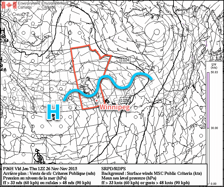
The passage of a low pressure system to the east of Winnipeg this morning will usher in cooler air as an Arctic ridge of high pressure builds in across the Prairies. As the ridge builds over Manitoba, temperatures daytime highs will end up falling quite a bit below the seasonal value of –5°C for this time of year, possibly not even breaking the minus double-digits on Thursday. The colder weather will be short-lived, however, as a potentially breezy Saturday holds promise of returning above-seasonal temperatures to the region just in time for the 103rd annual Grey Cup on Sunday.
Temperatures will be on a downward slide today as northerly winds to around 30km/h—with gusts up to the 50km/h mark—usher in cooler air and a large ridge of high pressure sourced from the Arctic. There will be some light snow or flurries around this morning, but they’ll be light and should taper through the morning. By supper time, temperatures will have fallen to around –7°C with the northerly winds still blowing. Heading into the overnight period, the winds will start to taper off with the cloud cover breaking up a bit, but there will be plenty of cloud streaming southwards off Lake Manitoba & Winnipeg through the night.
By Thursday morning, a large ridge of high pressure will be moving over Southern Manitoba.
Thursday may end up being the coldest day so far this November with temperatures struggling against the Arctic air entrenched over the region. Temperatures will climb to around –10°C by the afternoon with winds out of the north to around 20km/h. Skies will be partly cloudy thanks to a continued stream of cloud cover coming off of the lakes, in particular Lake Winnipeg. If you find yourself underneath any of the lake cloud, you’ll likely see some snow, however it looks fairly light and probably won’t accumulate much. Temperatures will dip to only about –13°C on Thursday night as slightly warmer air begins moving in as the ridge slumps to our south.
Seasonal weather will return to Winnipeg on Friday with mainly sunny skies and a high near –6°C. Winds will be fairly light. Temperatures will fall to around –9 or –10°C on Friday night with winds picking up out of the south.
Looking Towards the Grey Cup
The story for this weekend will be warmer weather returning to Southern Manitoba. On Saturday, gusty westerly winds will bring daytime highs approaching –2 or –3°C.
Grey Cup Sunday is a bit of a trickier forecast at this point, but the best guess I have this far out is that temperatures will likely be seasonal with a high somewhere near –6°C or so and light winds. By the time the football game starts, temperatures will probably be somewhere near the –10°C mark, so bundle up!
More snow is on the way this week, probably not what you were hoping to hear (at least most of you).
Monday
Today will feature mainly cloudy skies and more snow! There will be a chance of flurries throughout the day as we remain under a cloud deck with some low-level instability. Accumulations of new snow aren’t expected to be large, but will not be welcome by most nonetheless. Luckily, temperatures will remain near 0C, allowing snow to easily melt off treated surfaces. Winds will also be relatively light, preventing the white-out conditions we experienced last week.
Tuesday
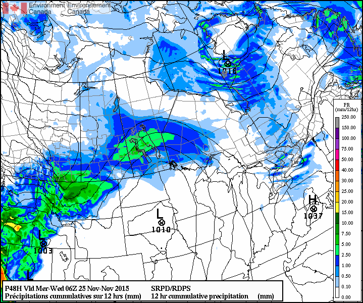
We’ll likely see a break from the snow on Tuesday morning, but more is on the way later on Tuesday. A stronger low pressure system will be pushing into southern Manitoba from the west, bringing more accumulating snow by later on Tuesday.
A large swath of snow is expected to move through southern Manitoba on Tuesday.
At this point accumulations looks to be around 5ish centimetres, but that number may go up or down depending on the eventual track of the system. Winds will be easterly at 30km/h gusting to 50km/h, leading to blowing and drifting snow out on the highways. However, temperatures will still be hovering near 0C, again helping to prevent ice from forming on treated roadways.
Wednesday
Snow will taper off on Wednesday morning, followed be clearing skies through the day. Unfortunately, a cold front will push through southern Manitoba on Wednesday morning, ushering in gusty north winds and a chillier air mass. Wind speeds are expected to increase to 40km/h gusting to 60km/h, allowing for more blowing and drifting snow. Temperatures will fall throughout the day as this colder air mass floods in, with temperatures dropping to the minus double digits by evening.
Long Range
The long range forecast continues to show generally above-seasonal weather for southern Manitoba as we push further toward winter (remember it’s not technically “winter” yet). This November is running 6.4C above normal, although that is going to change with the colder pattern that we’re currently in. Unfortunately, we live in Manitoba, so even “warm” winter weather is never really that warm, but hopefully we’ll avoid the extreme cold that has plagued us frequently the last few winters.