Temperatures will moderate to seasonal values by the end of the weekend, but the Victoria Day holiday may end up being quite wet.
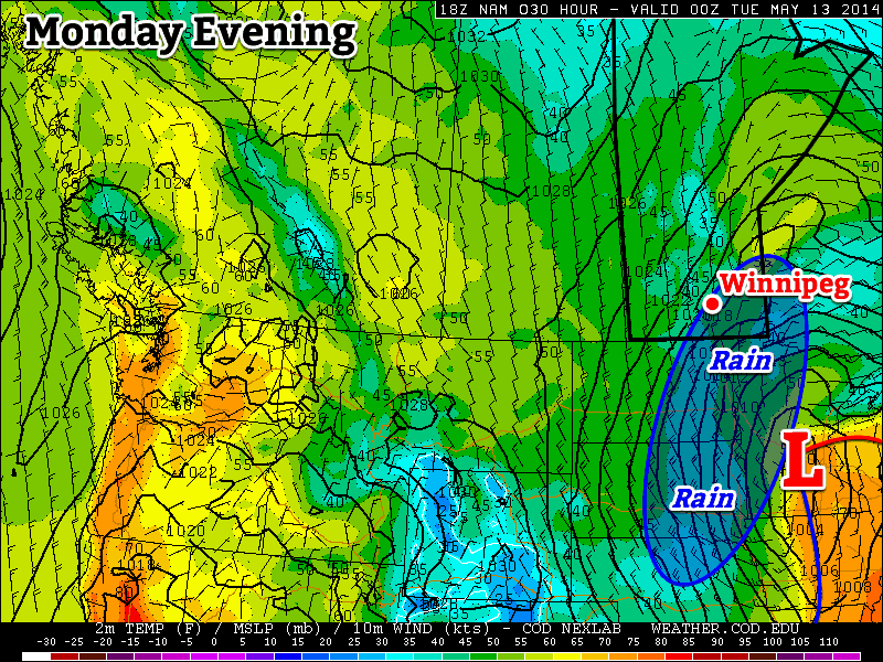
Relief is in store for Southern Manitobans weary of the prolonged cold weather as milder air is finally set to return to the region. The intense upper-level cold trough over Ontario that has been bringing a strong northerly flow and cool weather to the region will finally begin to collapse, allowing milder air to work its way eastwards again. Temperatures will remain fairly mild while the weather takes a turn for the worse on Victoria Day as a low pressure system brings the potential for substantial rains across much of Southern Manitoba.
Today and tomorrow will see daytime highs climbing towards the high teens with minimal in the way of cloud cover. Both days will also see light winds thanks to a ridge of high pressure situated over the province. We’ll likely see temperatures dip to the freezing mark tonight[1], but milder air will be in place for Saturday night making the overnight low around 5°C warmer.
Sunday will be a more unsettled day. Most places in Southern Manitoba will see cloudy periods with a very marginal chance of a shower. Winds will shift out of the south to 20-30km/h as a warm front lifts northwards through the day. Temperatures should climb to around 18°C and the temperature will drop to around 8°C on Sunday night.
Potentially Stormy Victoria Day Holiday
A powerful low pressure complex will develop over Saskatchewan on Monday which will bring wet weather to Southern Manitoba as a conveyor belt of warm, moist air sets up all the way from the Gulf of Mexico. We won’t see that warm, humid air at the surface, but thanks to a strong southerly flow aloft, strong isentropic ascent over the warm front will produce a very saturated, potentially unstable atmosphere over Southern Manitoba.

What does this mean? We could see fairly heavy rainfall on Monday. There is still enough time for things to change substantially between now and then, but amounts anywhere from 5-25mm seem quite possible. The rainfall does seem quite convectively driven, and with a moderately strong 850mb jet there’s always the possibility the rainfall becomes attached to the left-exit region and ends up remaining to our south/southeast. We’ll be tracking this system through the weekend and have updates below when things begin to take shape.
- Hopefully for the last time until the fall. ↩