Wet Week Leads to Gradual Improvement

A couple more days of unsettled weather will give way to some of the warmest temperatures of the year.

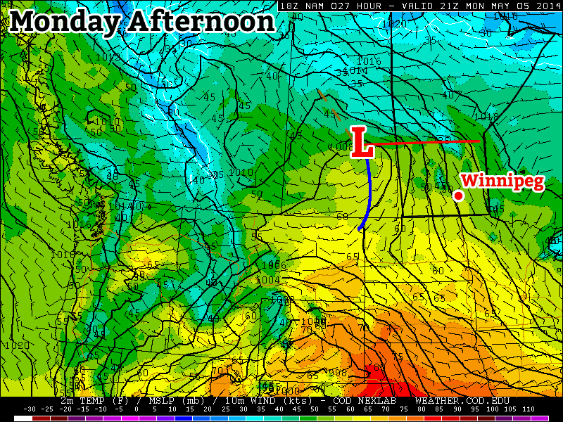
The main weather story will be gradual improvement as the week progresses. Currently we’re under the influence of a broad trough of low pressure that has brought scattered showers to the Red River Valley over the past couple days.

A complicated, high-amplitude flow is developing over the eastern Prairies.

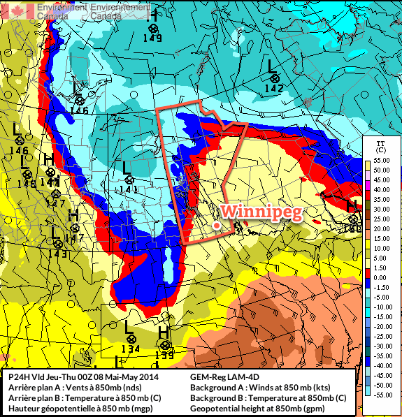
Multiple bands of precipitation will be in place over Southern Manitoba today thanks to multiple disturbances and a fair amount of instability. As the upper-level flow finally organizes itself, a Colorado Low eject northeastwards on Thursday bringing potentially significant rainfall to the Red River Valley and Southeastern Manitoba. The unsettled weather will linger through Thursday night but then a weak ridge of high pressure will begin building in from the west, bringing more settled weather with relatively warm temperatures, especially compared to what we’ve been suffering through so far this spring.

Wednesday
12°C / 6°C
Mainly cloudy. Occasional showers likely.

Thursday
12°C / 4°C
Showers, possibly heavy at times. 5-15mm.

Friday
15°C / 5°C
Clearing.

Today

Today will bring mainly cloudy skies to the Red River Valley as a large low pressure complex stretching from Northern Saskatchewan to Colorado slowly begins organizing itself. More organized showers will fall through much of the day west of the Red River Valley through southwest regions and the Parkland with total accumulations around 5-10mm, but here in the valley we will likely only see scraps of elevated convective showers occasionally moving over the area.

I say likely since there is pretty high uncertainty in exactly how this system will evolve today. The band of showers to our west will slowly creep eastwards towards the RRV through the day and likely push into the western Red River Valley this afternoon. There’s a chance that it will continue pushing eastwards, and if that’s the case then we might see some more organized precipitation later in the afternoon into the evening. There’s also a very outside chance that this whole thing bumps eastwards mid-morning and we’re the ones stuck under the showers for the day.

Complicating matters will be a secondary band of precipitation that will develop this afternoon and lift northwards out of North Dakota and Minnesota. It’s currently forecast to just clip SE Manitoba, but if the upper level trough tilts a bit more, which it has been doing more than the models have been forecasting for 2 days now, that band of rain could end up inside the Red River Valley.

As a third complicating factor, there seems to be fairly unstable mid-levels over most of Southern Manitoba, so even if the precipitation stays to our west and east, there will still be a chance for some light showers zipping across the valley.

Total precipitation by Thursday evening from the RDPS. The question is will it even be close to right?

It’s a very complicated setup; most models agree that there will be rain on the western and eastern fringes of the Red River Valley with little in between[1], however slight variations in the actual positions of systems could change things quite dramatically. For that reason I’m say that there’s a good chance we’ll see occasional showers today. We may see more, we may see less, but this is a situation where trying to be any more specific than that will likely be a futile effort.

What is a little more certain is that we’ll see a high near 12°C today with light southeasterly winds.

The threat for showers will continue through the overnight period through most of the Red River Valley. We’ll drop to a low around 5 or 6°C with winds shifting around to the north.

Thursday

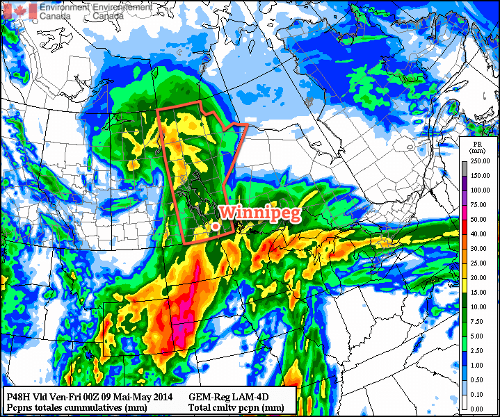
Thursday looks to be the most active day. A strong Colorado Low will track into Minnesota, spreading rain ahead of it into Southern Manitoba. Moderate instability aloft coupled with strong lift and enhanced convergence thanks to the deformation zone will result in showers, potentially fairly heavy at times, through much of Southern Manitoba. There may even be a very slight chance of a rumble of thunder or two.

The wet weather will likely last through much of the overnight period as well. By the end, anywhere from 5-15mm of rain seems likely over the Red River Valley; amounts will likely vary over short distances, and it’s impossible to say where will see the most rain until we’re closer to the event. I’d really love to be more specific, but with this rapidly developing, complex system, the models can be quite misleading and the best forecast will come from observing what’s actually happening and how things are developing in real time.

The high temperature on Thursday will be near 11-12°C once again, and the overnight low near 5°C.

Friday and Beyond

The weather finally looks to turn towards a more pleasant pattern for the end of the week. A cut-off cold low will spin aimlessly over the northwestern Prairies, leaving us on the warmer side of things as slightly milder air manages to work its way into the region. No substantial warm push is on the way, but with the cold air locked up well to our northwest, temperatures should manage to climb to around 15-16°C on Friday, Saturday and Sunday.

It seems quite likely that we’ll see our warmest day of the year this weekend. Currently, the warmest day we’ve had was a mere 15.1°C on April 23rd, but Saturday looks likely to beat that by a degree or so. Overnight lows are expected to sit near 5-6°C through Friday, Saturday and Sunday, which will be right around normal for this time of year.

Skies should be mainly sunny on Friday and Saturday, however we will likely see some cloud and a very slight chance of a shower on Sunday as a weak low pressure system pushes into western Manitoba.


  1. And I’m inclined to believe it given how often any sort of convective precipitation manages to end up on either side of Winnipeg.  ↩

State of the Climate: The Year So Far

Editor’s Note: Something I’ve wanted to do far more frequently than I’ve been able to is comprehensive climate statistics for Winnipeg. In between the regular posts, occasional event summaries and keeping this website humming along, I simply haven’t had the time time to get my personal climate archive quite up to snuff yet to really dig into things. So, I’d like to introduce a new contributor to the AWM team, Julien (@jjcwpg on Twitter). He’s the proprietor of Winnipeg Weather, does fantastic work with climate statistics[1] and will be in charge of seasonal climate updates as well as summer severe weather climatologies, similar to his guest post covering last summer’s thunderstorm statistics across the province. Since Julien is joining the team mid-season, we’re doing a “Year so Far” climate summary to bring readers up to speed on the current climate story for Winnipeg – hint: it’s cold – and to introduce him. So without further ado, here’s the first post of our new feature: State of the Climate!


Quite the year so far!

It’s no secret that 2014 has been an unusually cold year so far; in fact, we’ve managed to reach some impressive milestones in the last few months. Our brutal winter is now long gone and most of you probably want to forget about it (me as well), but before doing so I do have some interesting statistics about the winter of 2013/14 that I think are worth sharing.

To start off, this past December to March period didn’t only feel like one of the harshest ever recorded in Winnipeg, it statistically was. Our mean temperature (an average of all daily highs and lows) was -18.4°C, making it the coldest December to March period in 115 years. However, because we only tied with the winter of 1898-1899 for 11th coldest, we have to go back 121 years to find a December to March period that was even colder than this year’s. With 124.6cm of snowfall, it was also the 12th snowiest December to March period. Combining 12th snowiest with 11th coldest truly made this past winter one of the harshest since records began in Winnipeg in 1872.

In total, there were 90 days below -20°C between December and March, tying 6th most since 1872 and the most in 121 years! That’s 74% of all available days! The 1981-2010 normal is 51 days. The following table summarizes the number of -20°C and -30°C days we had from December to March.

Days below -20°C and -30°C
December 2013 to March 2014
Month Days below -20°C Days below -30°C
December 25 (tied 6th most) 9 (tied 15th most)
January 26 12
February 24 (tied 13th most) 6
March 15 (tied 20th most) 2
Total 90 (tied 6th most) 29 (tied 19th most)
Anything within the top 20 is noted.

The winter minimum was -38.0°C on January 5, the coldest temperature in Winnipeg since a -41.7°C low in February 2007. The high of -30.2°C for the day was not only a record low maximum but also the coldest since a -30.8°C high on Jan 30, 2004.

Many of you might remember the super cold day we had on March 1. Well, I’d say that was the most anomalous day of the winter. The low of -37.0°C that day was actually the 9th coldest in March since 1872. The high of -26.0°C obliterated the old record low maximum of -22.2°C in 1972 and was the second coldest in March on record. The mean temperature for the day was -31.5°C, making it the second coldest March day since 1872. In fact, this was a whopping 21°C below normal for the day, almost as extreme as March 2012’s 23.7°C above normal on March 19, 2012. Of course, to Old Man Winter all this was not enough. A minimum hourly wind chill value of -49.6 at 7 am was the lowest ever in March since 1953. Previous record was -48.8 in 1962.

Cold Not the Only Story of 2014

Despite all the cold weather news to talk about this year, one warm record managed to stand out. On January 15, a high of 3.3°C broke the old record high of 2.2°C in 1973. However, this high was an amazing 30.7°C increase from a low of -27.4°C in the morning, the greatest single-day warmup on record since 1872[2]. The top 5 are given in the table below. The 30.7°C warmup took about 14 hours and peaked between 4 and 5 pm when the temperature rose 5-6°C in just 1 hour.

Top 5 Greatest Calendar-Day Warmups since 1872
Rank Temperature rise of… Date
1 30.7°C Jan 15, 2014
2 30.6°C Jan 20, 1874
2 30.6°C May 12, 1949
4 30.5°C May 19, 1899
4 30.5°C Jan 30, 1934
Note the fact that this statistic doesn’t consider how quickly the temperature rose.

Nonetheless, the cold will forever be remembered as the top story of early 2014.

Stubborn cold continues into spring

In more recent memory, the cold continued into April with near record lows at times mid month. At 4.2°C below normal, April was the 5th consecutive month averaging over 3.5°C below normal and 7th consecutive month averaging below normal in general; a streak which began in October. In fact, up to April 30 we’ve averaged -13.1°C for 2014, 5.3°C below normal for the period. This ties with 1996 for 15th coldest first third of the year since 1873 and 4th coldest in the last century. The following graph shows how each month so far this year has averaged compared to the 1981-2010 normal as well as the year-to-date average compared to normal.

2014 Monthly and Year-To-Date Temperature Deviations for Winnipeg, MB

Yet another couple impressive statistics have come from this year’s cold. Our winter snow pack still sat at 43cm deep on April 1, the 3rd deepest winter snow pack entering into April since 1955. It didn’t reach a trace cm until April 19, the 3rd latest on record, and disappear until April 21, the 8th latest on record.

Thank you for reading and we hope you all enjoyed this first State of the Climate post!


  1. Seriously, the number of stats he’s worked out is fantastic!  ↩
  2. In this case, when referring to a single day we mean a single calendar day.  ↩

Unsettled Week Ahead

Summer weather will continue to elude us as a complicated weather pattern is set to bring more unsettled weather this week. A series of moderate to strong disturbances will move through Southern Manitoba, each bringing a chance for rain. The first major disturbance looks to move through on Tuesday, with a second major disturbance coming through on Wednesday night.

The forecast surface weather pattern on Monday afternoon

At this point it appears that each of these pieces of energy will just bring light to moderate rain to parts of southern Manitoba. However, there is always the potential for heavier amounts if convective elements (i.e. thunderstorms) become embedded within the larger area of rain. These disturbances will be coming in from the south-west along a strong jet stream.

This strong jet may also be the focus for severe thunderstorms in the US Great Plains this week, so you may wish to keep tabs on that if you’re a thunderstorm enthusiast!

Monday

Monday
12°C / 5°C
Mix of Sun and Cloud

Today will be seasonably cool, with high temperatures in the low teens. Skies will be a mixture of sun and cloud to mainly cloudy, but at least no precipitation is expected. There will be a breezy south wind during the day, but it shouldn’t be quite as windy as it was on the weekend.

Tuesday

Tuesday
15°C / 6°C
Mainly Cloudy. Showers.

Tuesday is expected to feature showers in much of southern Manitoba. There is also a slight risk of a thundershower, which may lead to isolated pockets of heavier rain. Temperatures will be in the low to mid teens with a south wind once again.

Wednesday

Wednesday
15°C / 2°C
Mainly Cloudy. Chance of Showers.

Wednesday will be, you guessed it, unsettled once again, with the threat of showers remaining in southern Manitoba. Temperatures will be in the low teens, with a light northerly wind.

Long Range

The long range forecast suggests we’ll see warmer temperatures this weekend. By warmer, we’re talking probably upper teens or maybe low twenties. It won’t be anything spectacular, but those values will feel quite warm considering the weather we’ve seen as of late.

Elsewhere in Weather News: May 3rd, 2014

Severe Weather, including Tornadoes Rip through United States

It’s been a rough week in the south-central United States for tornadoes. Monday and Tuesday warranted two consecutive high risk outlooks by the SPC for central Arkansas and Mississippi/Alabama, respectively. The system did continue on further to the Carolinas, but conditions weren’t as ripe for tornadoes. As of Friday evening, NWS had confirmed 67 tornadoes from the outbreak and from these, 11 were of EF-3 strength or higher.

Sunday was predicted to be a big day tornado-wise across Arkansas but cloudy conditions in the morning prevented much daytime heating from occurring. A mesoscale convective system (MCS) had also passed through the region the night prior which could have further disturbed the environment. With that said, the environment did manage to sustain a violent supercell in central Arkansas on Sunday which spawned the EF-4 Mayflower/Vilonia tornado. The tornado was on the ground for a length of 66.5km, at its peak produced winds of 300km/h and had a width of 1.2km. Unfortunately 15 people perished from this tornado.

Velocity data of the Mayflower/Vilonia supercell before it hit Mayflower on Sunday. Notice the intense couplet (red and blues are close), a sign of strong rotation. (Source: Radarscope)

Monday was a threatening day with numerous supercells lined up from southern Tennessee all the way down to southern Mississippi, all a posing threat to drop a tornado because of the volatile environment. The Louisville, MS tornado was one of the most significant one spawned on this day, with an EF-4 rating. It tore through the town killing 9 people and injuring several more. The tornado was on the ground for about an hour, traveling 57km. Another town that took a direct hit on that day was Tupelo, MS. The tornado, which had an EF-3 rating, passed through the northern part of the city taking the life of one person.

Supercells across the US South on Monday, notice the overshooting tops associated with the powerful updrafts. (Source: NOAA)

Tornadoes were not the only thing that this system produced on Tuesday night as the MCS stalled out over the Pensacola area of Florida producing flash flood conditions across the region. Interstates were underwater, roads got washed out and parking lots full of cars could be seen underwater. Record-breaking amounts were recorded from this event (provided by Jeff Masters blog):

  • 144mm of rain in one hour
  • 520mm of rain for the event

This weekend the pattern is much calmer across the Southern US and Plains as the atmosphere recharges for the next trough coming ashore next week.