Snow Finally Arrives in Winnipeg

After a few dud events over the region snow is finally on its way to the Red River Valley, but exact amounts are still uncertain.

RDPS 10m Wind Forecast valid 18Z Saturday March 11, 2023
A stubborn Arctic High will remain entrenched over northern Manitoba as the next disturbance brings moderate easterly winds to the Red River Valley.

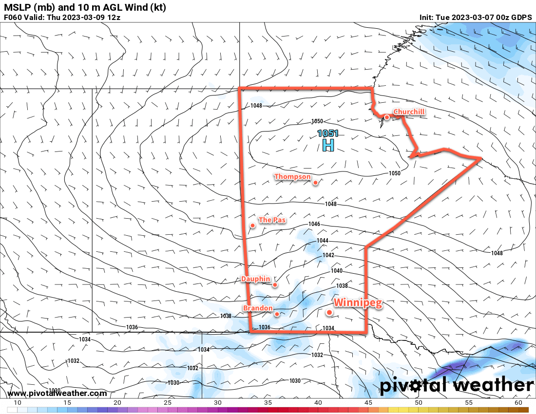
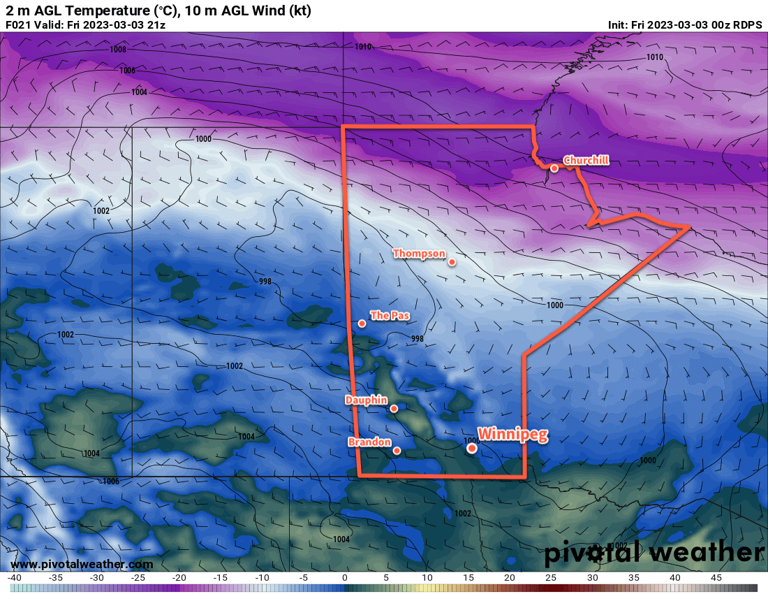
It’s been a complex weather situation over the Red River Valley over the past few days. The snow we earlier this week did develop as expected, and in fact, over the past few days was visible on RADAR as it streamed northwards over the region. But a stubborn Arctic High entrenched over northern Manitoba complicated things substantially.

This high was pumping copious amounts of cool, dry air into the northerly flow over the region which was pushed underneath the snow lifting northwards. This dry air ended up evaporating most of the snow before it managed to reach the surface. As a result, we saw little to no snow through the region over the past few days despite it falling a few thousand feet above ground.

This setup continues today, with cloudy skies and a slight chance of flurries. Temperatures will reach a high near -2 °C this afternoon, the d up down into the -5 to -10 °C range tonight.

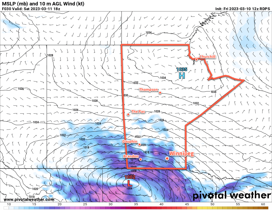
The third system we talked about in our last forecast is now developing in the west and will begin bringing snow to Saskatchewan tonight and then spread across Manitoba on Saturday. The snow will begin in Winnipeg mid- to late-morning on Saturday and persist to the evening before beginning to ease. Moderate easterly winds up to 40 gusting 60 km/h will accompany the snow, producing blowing snow across the region in the afternoon.

There is still some uncertainty with snowfall totals. Like with the previous systems, weather models have struggled to fully capture the impact of the Arctic High entrenched over the Northern Prairies. As a result, model runs have been slowly shifting the expected track of this system further south over the past few days, reducing the amount of snow over many parts of the Prairies. But the models do seem to be stabilizing their tracks, and it looks reasonable at this point that Winnipeg will likely see 5 to 10 cm of snow with this system.

ECMWF Accumulated Snowfall Forecast valid 00Z Friday March 10, 2023 to 18Z Sunday March 12, 2023
The ECMWF snowfall forecasts have begun to stabilize with 5 to 10 cm of snow for Winnipeg and higher amounts to the south and west.

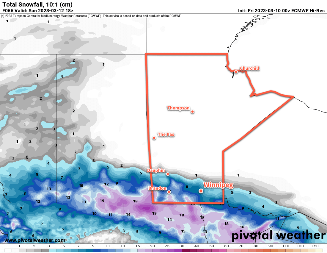
Further south, snowfall totals could rise quickly, especially along the western escarpment where snow will be enhanced by the persistent easterly winds. Heading southwards through the Red River Valley, accumulations will likely increase into the 10 to 20 cm range. The higher snowfall amounts coupled with the strong winds could result in very poor travel conditions, particularly near the International Border, on Saturday afternoon.

Temperatures will hover around -6 °C on Saturday, then dip down close to -10 °C on Saturday night.

Some light snow will linger through Saturday night and then taper off on Sunday. Temperatures will linger in the -5 to -10 °C range through the day under cloudy skies, then dip to a low in the -15 to -20 °C range overnight as skies clear.

Long Range Outlook

In the wake of this system, skies should clear as cooler air floods into the region. Seasonably cool temperatures will move into the region to start the week with highs generally in the -5 to -10 °C range.

Another disturbance will move into the region mid-week and could bring some more accumulating snow to the area along with warmer seasonal temperatures.

Today’s seasonal daytime high in Winnipeg is -2 °C while the seasonal overnight low is -12 °C.

Snowier Weather on the Way

After an extended period of benign weather, it looks like its going to get busier over southern Manitoba. A trio of disturbances are poised to bring snow to the region back-to-back-to-back over the next few days.

GDPS 10m Wind Forecast valid 12Z Thursday March 9, 2023
An inverted trough is forecast to develop and linger over the Red River Valley, bringing a prolonged period of light snowfall.

Before it all begins, though, Winnipeg will see a cool but pleasant day. Temperatures will climb close to the -10 °C mark with increasing cloud cover through the day. Winds won’t be too bad, either, persisting out of the northeast near 20 km/h. The region will see cloudy skies tonight with a low in the mid-minus teens.

The action begins tomorrow in what is, at the end of the day, a bit of a complicated setup.

The simplest explanation of what’s going to happen over the next few days is this. The complex evolution of a multi-circulation vortex over western Canada will result in the development of an inverted trough over southern Manitoba on Wednesday. This feature will bring light snow northwards out of the U.S. into the region through the day. The inverted trough will linger over the region while another disturbance passing through the U.S. pushes more moisture northwards on Thursday. As it moves into the trough, more light snow will fall over southern Manitoba into Friday. Following that, a clipper system will develop over southern Alberta on Saturday morning and race eastwards across the southern Prairies. This will bring another organized band of snow — perhaps the heaviest of them all — to the Red River Valley on Sunday.

Between each of these features, lingering flurries or light snow will likely persist across the region.

Snowfall totals by Sunday night will be highly variable across the region with amounts of 10 to 25 cm possible in Winnipeg across the three events. Localized accumulations could end up being higher, though, and of most concern will be areas near the western escarpment of the Red River Valley. The persistent upslope flow on the western side of the inverted trough will enhance snowfall near the escarpment. In those areas, there is the potential for as much as 20 to 40 cm of snow over the next several days.

The snow won’t all fall at once; it will be through multiple events — maybe none of which are particularly bad. But the prolonged nature of the event will mean that it will slowly pile up across the region.

Temperatures will be pleasant, though as daytime highs warm up into the near-seasonal -5 to 0 °C range with overnight lows of -5 to -10 °C.

This is a complex weather setup consisting of multiple events over several days. The forecast may change. One of the biggest uncertainties will be how well the inverted trough is able to establish with a strong Arctic High over the northern Prairies and how much dry air will be ingested from it and diminish snowfall amounts. But be sure to keep an eye on the updated ECCC forecasts and for any alerts that may be issued such as special weather statements or snowfall warnings in the coming days.

Long Range Outlook

Near-seasonal temperatures will continue next week with a bit of sun likely showing up to start the week. Some more flurries look possible mid-week as temperatures nudge warmer.

Today’s seasonal daytime high in Winnipeg is -3 °C while the seasonal overnight low is -13 °C.

Warmer Weather Returns to Winnipeg

Winnipeg has climbed out of the cold snap that brought bitter cold to the region last week and will see seasonably mild weather through the weekend.

RDPS 2m Temperature Forecast valid 21Z Friday March 3, 2023
Warmer weather will spread across southern Manitoba today.

A warm front that passed through overnight has pushed temperatures above -10 °C and it will continue to climb through the day today. A trough moving through this morning will shift winds westerly, helping push the daytime high to near the freezing mark this afternoon. All this will happen under partly cloudy skies.

Temperatures will dip down to around the -10 °C mark tonight with partly cloudy skies. The weekend will continue to bring warmth to the region with a high near the freezing mark on Saturday and a couple degrees cooler on Sunday. Winnipeg will likely see partly cloudy skies on Saturday give way to cloudy conditions for Sunday.

No notable snowfall is expected through the weekend, and lows will continue to sit near the -10 °C mark.

Long Range Outlook

A cold front will push through early Monday, ushering in stronger north winds. This will bring cooler temperatures into the region with highs dipping towards -10 °C by Tuesday. Northerly winds will continue into mid-week with highs in the -10 to -5 °C range and overnight lows in the -15 to -20 °C range.

Today’s seasonal daytime high in Winnipeg is -5 °C while the seasonal overnight low is -15 °C.

Quiet Seasonal Conditions Ahead

Benign, near-seasonal conditions will stick around for Winnipeg this week. The weekend looks to bring warmer weather back to the region.

RDPS 2m Temperature Forecast valid 21Z Thursday March 2, 2023
A push of warmer air will begin to move into Manitoba later Thursday.

Winnipeg will see quiet weather for most of the week as an Arctic high builds into the region. This one won’t be too bad, only sending daytime highs down to the -10 to -15 °C range for Wednesday. Overnight lows the next couple nights will dip down into the -20 to -25 °C range.

On Thursday, a stiff southerly wind will develop as the high departs the region. Winds will strengthen up to around 40 gusting 60 km/h with the morning chill breaking through the day. Temperatures should climb to a  high in the -5 to -10 °C range.

On Thursday night, a push of much warmer air will continue moving into Manitoba. The cloud cover will thicken up on Thursday night, keeping lows warmer near -10 °C.

On Friday, the warmer temperatures will climb to a high near the freezing mark with a chance of afternoon flurries.

Long Range Outlook

The warmer weather will persist through the weekend with highs in the -5 to 0 °C range. The region will see variable cloudiness with a bit more sun likely on Saturday and a bit more cloud on Sunday. Quiet, mild weather will continue for Monday, then a disturbance moving into the region could bring a chance for some light snow later on Tuesday into Wednesday.

Today’s seasonal daytime high in Winnipeg is -5 °C while the seasonal overnight low is -16 °C.