This weekend will be marked by bitterly cold temperatures as an Arctic high builds into the Prairies, bringing with it the coldest temperatures we’ve seen so far this winter.
Friday -18°C / -26°C Mainly cloudy with some scattered flurries.
Saturday -22°C / -28°C Gradual clearing through the afternoon.
Sunday -21°C / -27°C A mix of sun and cloud with a chance of flurries.
We’ll see mainly cloudy skies today as the remnants of this weeks winter storm still hang back a while longer. Some light flurry activity will likely slump down from the Interlake by midday brining some light, non-accumulating flurries to most of the Red River Valley. There will be a brisk northwesterly wind at around 20–30km/h today which, when coupled with a high of only around –18°C, will make it feel closer to the –25 to –30 range. The clouds will stick around through the night with perhaps a clear break or two and we’ll drop to an overnight low of about –26°C.
Saturday will start off with mainly cloudy skies and we’ll climb to a high of –22°C. Skies will begin to clear through the afternoon and we’ll be left with mainly clear skies for tomorrow night as we dip down to around –28°C for an overnight low. Winds will be relatively light at 15–25km/h out of the west.
Sunday will bring mixed skies as Winnipeg sits between a system tracking through the Northern Plains and another system sliding down into Southern Manitoba from the northwest. We’ll see a chance of some light flurries through the day, but at this point no significant snowfall is expected. Temperatures will top out around –22°C, however the winds will be increasing out of the south as a return flow develops on the back-side of the Arctic high. This will make things feel quite cool with wind chill values dropping down to as low as the –30 to –35 range. It will be a generally unpleasant day. The risk for flurries will continue through Sunday night as temperatures down to around –28°C.
The remainder of the week will be defined by a significant storm system moving through much of central North America. This system has two main areas of snow: one through the Great Lakes associated with a powerful surface low and it’s fronts and a second one that will impact us associated with the system’s upper low moving into the region. Snow and blowing snow will be replaced by bitterly cold Arctic air moving in for the weekend that will entrench itself into Southern Manitoba for the first frigid winter blast of the year.
Tuesday Night
Tuesday Night -14°C Periods of snow. 2-5cm accumulation.
The snow has already started flying through much of the Red River Valley and will continue to do so through much of the overnight period. There may be breaks here and there, but for the most part mainly snowy conditions are expected with a total of 2-5cm of snow piling up before the main system moves in tomorrow morning. The winds will increase to 30 gust 50km/h fairly early this evening, and there may be local areas of blowing snow giving reduced visibility. The early start to the snowfall will ensure that highway conditions will already be in a somewhat deteriorated state by morning. We’ll see temperatures drop to around -14°C tonight.
Wednesday → -14°C / -16°C Snow. 10-20cm by Thursday morning.
Snow will persist through to Thursday morning and will be very fluffy which will help it pile up relatively quickly We’ll likely see 5–10cm on Wednesday with another 5–10cm Wednesday night, bringing a total to somewhere between 10–20cm for the City of Winnipeg by Thursday morning.
In addition to the snow, moderate northerly winds will develop, increasing to around 30km/h with gusts to around 50–60km/h. These winds would usually not be too much of a concern, but with such fluffy snow falling, blowing snow will likely be a concern for anyone planning to do highway travelling. With winds out of the north, visibilities on Highway 75 will likely be restricted mostly by the falling snow, but any west-east highways will likely have significant drifting and blowing snow. Of particular concern will be the Trans-Canada Highway from Winnipeg to Portage la Prairie; ever battered by blowing snow, travel conditions along that stretch will likely deteriorate fairly quickly through this morning. The winds may not be strong enough to result in closure of the highway (although I wouldn’t rule it out), but they will certainly make travel more difficult.
Forecast storm-total snowfall amounts for Southern Manitoba.
The snow will begin to taper off late Wednesday night, perhaps into Thursday morning, with many areas in Southern Manitoba seeing close to 15–25cm of new snow. Although the significant snowfall will be done for Thursday, the wind will be another story.
Thursday
Thursday → -16°C / -22°C Flurries; blowing snow in open areas.
Most of the snow will have tapered off by tomorrow morning, but we’ll still see widespread light flurry activity today which may end up adding another 2cm of snow or so to the totals for any areas that see more prolonged activity. The bigger news will be the northwesterly winds, 30–40km/h that will be blowing through the valley bringing in cold, Arctic air.
As the low pressure system moves off to our east, a bitterly cold Arctic high will begin building into the region. The colder air pushing in will prevent our temperature from rising much on Thursday and will give a pretty nasty bite to the wind. Wind chill values will sit in the –25 to –30 range, making it one of the first truly cold days of the year. In addition, some low-level instability caused by the cold air advection will combine with the northwesterly winds and fresh, fluffy snow to continue producing blowing snow through the Red River Valley in most open areas. With northwesterly winds, most highways will be affected by drifting or blowing snow.
The clouds will begin to break up overnight with some continued scattered flurry activity as we drop to a low of around –22°C.
The sun will begin to peek out on Friday after what seems like forever of being cloudy. Unfortunately, that seeing that big bright ball in the sky is thanks to the Arctic high settling over the region, which means we’ll also be bitterly cold. Our daytime high won’t really recover from Thursday night’s low and we’ll just be heading down, down, down for the weekend. The winds will also be lighter ending any blowing snow concerns. We may end up seeing some flakes of snow out of whatever clouds are around, but they won’t produce any accumulations.
Skies will clear completely on Friday night as we drop to around –26°C for an overnight low.
The Weekend Ahead
Cold.
Very cold.
As the Arctic ridge really entrenches itself over the province, we’ll likely see our first overnight lows dropping below –30°C this weekend, perhaps even into the mid-minus–30’s. We’ll end off the weekend/start the new week with a chance of some snow as a system dives down through the province. At this point it doesn’t look like a very significant system.
Our weather may be about to take a turn towards more active conditions, as a major winter storm looms this week.
A Powerful Low Pressure System is Forecast to Impact Southern Manitoba on Tuesday
Monday
Monday Cloudy. Snow. -4°C / -8°C
The weather will begin to take a sour turn on Monday, with some initial bands of snow moving through Southern Manitoba. Areas along the International Border could see 5-10cm of snow through the day on Monday, with areas further north receiving 2-5cm. Temperatures will remain in the single digits with gusty north-east winds.
Tuesday
Tuesday Snow. Blizzard Possible. -8°C / -15°C
Tuesday is when things could really get ugly. As of Sunday evening, models were suggesting that this winter storm may move into north-western Minnesota on Tuesday evening, with it’s pressure dropping below 1000mb. At the same time, an arctic high is forecast to slide down into Alberta, generating a large pressure difference across the prairies. This pressure difference will generate very strong winds by late Tuesday. If this storm also produces snow in Southern Manitoba on Tuesday as we currently expect, then the combination of that snow and very strong winds will generate blizzard conditions. Total snowfall on Tuesday into Tuesday night could be 10-20cm in Southern Manitoba along with wind speeds of 40-50km/h gusting to 60-70km/h. Travel may become very difficult to impossible by Tuesday night.
Wednesday
Wednesday Blizzard Ending -15°C / -20°C
Snow may continue into Wednesday morning, along with the strong winds. If this storm tracks as currently expected we could see blizzard conditions persisting through a good part of Wednesday in Southern Manitoba. The wind should taper off somewhat on Wednesday night, but it will remain breezy on Thursday.
Long Range
The long range forecast is pretty simple – it will be COLD! After this week’s weather system departs on Wednesday we will see arctic air take over, and it will be the coldest airmass so far this season.
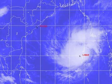
This past week a weak cyclone hit India’s east coast as a weak cyclone depression. The cyclone – Cyclone Lehar was classified as a severe cyclone in the Bay of Bengal with winds over 100km/h but has since been downgraded. Unfavorable sea surface temperatures and shear for storm development did a good job on tearing up the storm apart before landfall. The storm made landfall as a tropical depression on Thursday, with winds of 60-70km/h at landfall. Evacuation precautions were taken by the India Meteorological Department because of the strength of the cyclone while it was over the Bay of Bengal but the only real threat that Lehar brought was flood threat. No significant damage was reported from the storm but some crops have been damaged and a few districts vulnerable to flooding in India’s Andhra Pradesh state have been affected by flooding.
Cyclone Lehar as it was struggling to organize over the Bay of Bengal. (Source: NDTV)
Arctic air dominated over a good part of both Europe and the United States this week which brought minimal significant weather to the regions. Apart from significant snowfall associated with a trough of low pressure affecting the eastern seaboard of the United States earlier this week, active weather has been kept to a minimum. The next big weather event is likely to be a winter storm which will affect the northern states (MT, ND) and even southern Manitoba on Tuesday and Wednesday of next week.