Milder Weather On Tap

A broad trough of low pressure will push eastwards across the Prairies bringing with it milder temperatures and the occasional chance for some more light snow.

Friday

-7°C / -14°C
Mainly cloudy with flurries.
Saturday

-8°C / -12°C
Mixed skies; slight chance of isolated flurries.
Sunday

-8°C / -10°C
Cloudy with a chance of scattered flurries.

We’ll see fairly cloudy skies today alongside an increasingly brisk southerly wind to 30–40km/h as a warm front approaches the Red River Valley from the west. This front will produce an area of 5–10cm of snow through the Interlake and areas west and north, but here in the Red River Valley we’ll see some periods of light snow with no significant accumulations expected. Temperatures will climb to around –7°C as the winds ease up in the afternoon and see gradual clearing through the evening and overnight as the mercury then drops to about –14°C.

Saturday will bring a few remnant clouds in the Red River Valley that will possibly produce some isolated flurries, but it should end up being a mostly sunny day with light winds and a high near –8°C.

Cloud will roll in on Saturday night as a low-pressure system begins working it’s way across North Dakota. The accumulating snow is expected to remain States-side at this point, with just some light snow working it’s way north of the border. Minimal accumulations are expected at this point, although regions close to the U.S. border could possibly see a cm or two of the white stuff if the system tracks just a smidgen further north.

The Start of Next Week

The first half of next week looks to bring some very mild air into Southern Manitoba with temperatures climbing as high as low minus-single-digits on Monday! It will be short-lived, however, as a significant cold trough begins working it’s way into the Prairies and brings below-normal temperatures for the second half of the week.

Snowy Mid-Week Interlude

A trough of low pressure pushing across Southern Manitoba today will spread light snow into the Red River Valley this morning.

24hr. accumulated precipitation from the RDPS for today and tonight. General amounts of 2-3mm, equating to 2-5cm of snow will be expeted through the Red River Valley.
24hr. accumulated precipitation from the RDPS for today and tonight. General amounts of 2–3mm, equating to 2–5cm of snow will be expeted through the Red River Valley.

The overall pattern will flatten out after this system, bringing us out of the warm-cold roller coaster and back into a more stable — albeit slightly below normal — temperature pattern.

Today

Wednesday

-8°C / -14°C
Light snow starting this morning. Flurries this evening & overnight.

We’ll see a cloudy start to the day with snow pushing towards Winnipeg & the Red River Valley from the west and northwest. Light snow should push into the area by mid-morning. The heaviest snow will occur midday before tapering off through the afternoon. We’ll climb to a high temperature around –8°C today, which is still a couple degrees below normal for this time of year. The organized snow will move off by the evening, however lingering scattered flurries will likely persist through the evening and overnight periods. Skies will remain mainly cloudy until either late overnight or early tomorrow morning. All in all, not too much snow is expected, with around 2-3cm likely but with 5cm possible as an outside chance.

Thursday & Friday

Thursday

-10°C / -16°C
Mainly sunny.
Friday

-10°C / -13°C
Mainly sunny.

We’ll move into a quieter, more stable pattern for the remainder of the work week with a slowly weakening northwesterly flow aloft. We’ll see mostly sunny skies both Thursday and Friday with daytime highs near –10°C. We may see some light snow on Friday night as a weak warm front pushes across Southern Manitoba.

The Weekend

A broad area of low pressure will be in place across the Prairies this weekend bringing some cloud and slightly warmer temperatures. Models are showing a slight chance of more snow to start next week with an Alberta clipper racing along the 49th. As always, we’ll be keeping an eye on things!

Remaining Cold

Conditions will remain cold to start the week…and just think we’ve only got another 3-4 months of this weather yet to come!

This Week

Monday

Increasing Cloudiness. Chance of Flurries.
-7°C / -15°C
Tuesday

Mainly Sunny
-13°C / -22°C
Wednesday

Mainly cloudy. Slight Chance of Flurries.
-10°C / -12°C

The weather today won’t offer a very pleasant start to the week. High temperatures will be in the low single digits, with a brisk north-westerly wind, making it feel much colder than it actually is. There may be a few flurries as well – have you heard enough?

Tuesday will remain cold, with temperatures in the minus teens. The wind will be a bit lighter though, which is a bit of consolation.

We should see a southerly flow develop in Southern Manitoba on Wednesday, perhaps allowing temperatures to approach the -10C mark. A weak weather system may also bring some flurries on Wednesday.

Elsewhere in Weather News: November 29th, 2013

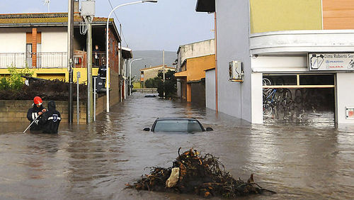
Flooding Affects Italy

Severe flooding has been taking place in Sardinia, Italy this past week causing residents to rush for higher ground. Sardinia is one of Italy’s islands located in the Mediterranean Sea; about 1.7 million Italians reside here. An upper level low drew in moist air from the Mediterranean Sea and spun just off the coast of Sardinia, causing for some significant flooding on the island. Rainfall totals generally ranged between 35 and 50mm on the island, which is over half of their monthly total for November.


Severe flooding in the city of Uras, on the island of Sardinia. (Source: AP)

As this fell in a span of about 24 hours, sewers were unable to handle these large volumes of water in that short period of time. In some areas water levels reached about three meters, causing roads and bridges to be washed away. As of Friday night 18 fatalities had been reported. Several waterspouts and brief tornadoes had also been spawned by this system off of Italy’s coast and on the mainland.

Tornadoes Rip through US Midwest

In last week’s post of EIWN the risk for severe storms affecting the Midwest US had been briefly talked about. The event that occurred on Sunday was a fairly significant event; the moderate risk talked about in last week’s post had been upgraded to a high risk on Sunday – a risk only issued once or twice by the SPC when major severe weather events are imminent. This severe weather event followed up with all the hype ahead of it. In total, 106 tornado reports were received and 74 tornadoes were confirmed. Two of these were classified as EF-4 strength and 33 classified of EF-2 strength and higher, making November 17th a significant tornado outbreak in the Midwest. There were also numerous (400+) wind damage reports scattered from Iowa to New Jersey, as expected with the high shear environment on that day. One of the strongest tornadoes of the day – an EF-4 ripped through the town of Washington, Ill., where some houses were completely ripped apart by the twister. Death toll from the outbreak is at eight but could have been significantly higher if not for the good forecasting and swift warning issuance by NWS.


Map of all the warnings and watches issued on the 17th. Tornado watches/warnings in red and severe thunderstorm watches/warnings in blue. Polygons are the warnings. (Source: SPC)
Map of all the warnings and watches issued on the 17th. Tornado watches/warnings in red and severe thunderstorm watches/warnings in blue. Polygons are the warnings. Click on image to enlarge. (Source: SPC)