The chilly, below normal, temperatures are set to continue through the beginning of this weekend. There is a glimmer of hope though as a clipper system is expected to bring a bit of reprieve from the bone-chilling temperatures towards the end of the weekend, but this “warmer” weather will be short-lived.
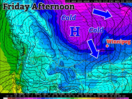
Arctic high sliding down into Southern Manitoba on Friday afternoon.
Friday
Friday -12°C / -22°C Winds gusty, clouds clearing in the evening.
The day will start off as overcast, if not for lingering flurries still affecting Winnipeg from a weak system that passed last night. Winds will be stiff today coming from the north-west in the 25-30km/h range as the high pressure pushes south. Tonight you will want to make sure to crank the heat up as the low temperatures will bottom out around -22°C in Southern Manitoba, and even colder in the southwest corner of the province as the Arctic high slides down.
Saturday
Saturday -15°C / -18°C Winds around 10km/h and mainly sunny skies. Cloud moving in overnight.
Saturday will be cold again. The Arctic high that pushed down will now be centered near the international border, which should keep us mainly cloud-free throughout the day but brisk temperatures will remain in place. Winds won’t be too strong from the west, perhaps 10km/h switching to southerly overnight. Lows won’t be dropping to levels as low as Friday night thanks to some cloud cover moving in associated with an approaching system.
Sunday
Sunday -4°C / -11°C Could be a few flurries, winds south becoming west in the evening.
For Sunday there is a chance for some flurry activity as a clipper system slides by. Accumulations shouldn’t be higher than a few centimeters for the Red River Valley, but higher accumulations to the northeast of Winnipeg are possible. High temperatures for Sunday won’t be as cold as Saturday thanks to some warmer air aloft associated with the clipper but don’t be deceived, winds will be quite gusty, especially in the afternoon.
Looking ahead into the next work week there does not appear to be too much significant weather, once again – both the CPC (Climate Prediction Center) and the NAEFS point towards near average temperatures. In addition to that he models don’t show any significant systems, at least for the beginning of next week.
Well, it had to happen eventually. The first real shot of winter is on it’s way as very cold Arctic air barrels southwards through the Prairies this week. The bright side? It should be relatively short-lived.
RDPS surface temperatures on Thursday morning show temperatures dipping down to –30°C over extreme SW Manitoba on Thursday morning.
Today marks the beginning of the big cool-down for us. A cold front that passed through overnight bringing in northwesterly winds and the leading edge of the cold air. Our temperature will remain fairly steady near about –7°C through the day with mostly sunny skies and a breezy northwesterly wind at 30–50km/h. We’ll see some increasing cloud towards the evening hours which will bring a slight chance of some flurries tonight as a weak disturbance slides through the Dakotas and southeastern Manitoba. Temperatures will dip to around –15 or –16°C tonight as colder air continues to infiltrate southwards.
Wednesday → -7°C / -15°C Cool and breezy. Chance of flurries tonight.
Thursday -14°C / -19°C Sunny and cold.
Friday -14°C / -23°C Chance of a morning flurry then sunny and cold.
Thursday will bring mainly sunny skies and cold weather as we climb to only around –14°C. The winds will be lighter which will help a little bit. Even more cold air is on it’s way, though. We’ll drop to around –19°C on Thursday night, but some clouds will build into the Red River Valley overnight into Friday morning as another weak disturbance dives southwards through Manitoba, bringing yet more cold air with it. We’ll see a very slight chance of a light flurry or two with the passage of this system, but it will be much more a “cold air bringer” than a snow-maker.
Friday will see mainly sunny skies, save for the possible clouds in the morning, and we’ll see temperatures rebound to around –15°C. Bitterly cold air will begin working it’s way in through the evening hours, though, and we’ll see our temperature drop all the way to –22 or –23°C on Friday night. Winds will be light, but it will likely still be quite easy to hit a –30 wind chill, so be sure to bundle up if you need to be out.
Fortunately, it doesn’t look like the cold weather will be here for long. Warmer air will be pushing eastwards across the Prairies quickly behind this system and we should see temperatures moderate back to the mid-minus-single-digits by the end of the weekend.
Winter Survival
With the first snow under our belt and the first shot of very cold weather on the way, it’s a good time to bring up winter survival. It’s certainly no joke and things that are minor inconveniences in warmer months – such as your car breaking down on the highway – can easily become life or death situations in winter time.
One of the first steps is making sure you have a winter survival kit in your car. They’re very easy to put together (you can also buy them an many retailers including Canadian Tire and CAA Manitoba) and can make the difference between life and death in some winter situations. To make your winter survival kit, find something like a small duffel bag or other bag you can ensure is sealed shut (e.g. snaps or zippers) and put in:
Ice scraper and brush
Flashlight and extra batteries
Booster cables
Shovel and tow rope
Flares or other signal aids
Sand or kitty litter
Candles and coffee tin (to
warm hands, heat a drink or use as an emergency light)
Matches/lighter (in a waterproof bag)
Blankets/warm clothing
Granola bars, candy, sugar cubes
First aid kit
Compass
Hatchet or axe
Cellular phone
Methyl hydrate (fuel line de-icing)
Traction mats
Cloth or roll of paper towels
Small fire extinguisher
Reflective vest
Not all of these need to be present for a basic winter survival kit; most important are ways to stay warm, visible, fed and safe.
The CAA has an excellent brochure available going over some winter driving tips.
Our RADAR Viewer can be very useful in tracking snow.
Also keep in mind that even if it’s not snowing, strong northerly or southerly winds in the Red River Valley tend to produce significant blowing snow on any west/east running roads and highways. I’ve had more than one trip to Altona that has had a beautiful sunny drive on Highway 75 turn into a dangerous, slow crawl through near-zero visibility after turning west onto Highway 14.
Lastly, one of the biggest dangers cold weather has on you is how it impacts your body. One of the primary things that is affected when your body’s core temperature drops is your ability to make decisions.
The cold remains a mystery, more prone to fell men than women, more lethal to the thin and well muscled than to those with avoirdupois, and least forgiving to the arrogant and the unaware.
Outside magazine did an absolutely excellent article about freezing to death. It’s superbly written and will help you understand what happens as your core body temperature drops. Even if you have an idea, give the article a read because it’s a phenomenal piece of educational writing.
Hopefully you never find yourself in a situation where you actually need to use any of this advice. It never hurts to be prepared, though. Here in Southern Manitoba we live in one of the harshest winter climates out there and all it takes is a few simple measures to make sure you’re ready for it. And, as I always mention, if there’s a significant winter storm and your travel plans are flexible, it’s always wiser to wait it out than push through it.
I hope this little section offers some help and that you can all stay out of the wind, safe and warm.
After a snowy, but mild weekend, we’ll see some warmer weather return – but it will be short-lived.
A southerly flow will bring slightly warmer air to Southern Manitoba on Monday
Monday
Monday Mix of Sun and Cloud. Chance of flurries/showers -1°C / -4°C
A southerly flow will develop through Southern Manitoba on Monday, bringing some slightly warmer weather along with it. There may be a few flurries on Monday, but no significant precipitation is expected. The wind will be relatively light and from the south.
Tuesday
Tuesday Mainly cloudy. 3°C / 0°C
Tuesday will be warmer than Monday, as a developing low pressure system ramps up that southerly flow from Monday. Hopefully Tuesday’s warm conditions will allow some of the weekend’s snowfall to melt. The wind won’t be much stronger than on Monday, but the direction will shift to be more from the south-east.
Wednesday
Wednesday Decreasing Cloudiness. Temperature Falling. -6°C / -14°C
The low pressure system that brought the warmer weather to Southern Manitoba on Tuesday will move into the region on Wednesday. It appears that this system will generate an area of moderate snowfall to the north of its track, but no precipitation to the south of its track. At this point it appears the system will track in a fashion that results in no snowfall for most of Southern Manitoba, save for perhaps some parts of Western Manitoba. Regardless of whether or not this system brings us snowfall, it will bring us colder weather. A strong cold front associated with this low will bring down another arctic airmass, dropping temperatures well below zero for Wednesday and Thursday.
Long Range
The long range forecast currently looks on the cold side. Following the passage of that cold front on Wednesday models don’t hint at any immediate return to warmer conditions. Bear in mind that we are quickly moving into late November, so warm weather will being harder and harder to come by. On the bright side there is still no significant snow in the forecast, so we’re not in a true winter pattern quite yet!
Typhoon Haiyan Final Update, Moderate Risk for Midwest US
It’s been over a week since super typhoon Haiyan made landfall in the Philippines and a second landfall over Vietnam. The impacts in the Philippines and Vietnam are just now starting to surface and the reports coming out of the countries are not good.
Vietnam had had quite a bit of time to prepare for the storm and 70,000 people were evacuated from low lying areas. These preventive measures surely saved lives in the flood-prone and landslide-prone areas of Vietnam, but unfortunately five people still lost their lives in the floods. Storm surge was not as big an issue as it was for the Philippines as Haiyan had significantly weakened by the time it made landfall in Vietnam.
For the Philippines the death toll continues to climb (3,600 people) as the cleanup continues. One neighbourhood of Tacloban City of about 10,000 people has been literally washed off the map according to the city’s mayor, with no houses left. An early estimate for the damage is 12-15 billion dollars.
Aerial picture of Guiuan, one of the hardest hit areas, to the east of Tacloban. (Source: National Post)
Unfortunately, this past week another tropical disturbance made its way to Vietnam and brought anywhere from 250mm to 500mm in the central part this past week. To the already saturated grounds, this was enough to cause some more flash flooding. As of Friday night’s reports 3,500 houses had been lost and power was out for various cities in central Vietnam. In total, 17 people had lost their lives from this event.
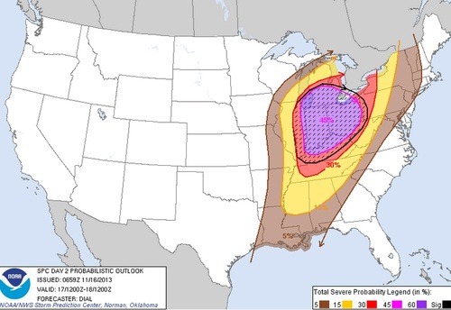
In other weather news this week, a negatively tilted trough will be making its way across the US Midwest and has the chance to produce some severe weather on Sunday. SPC has outlined a 45% hatched area, moderate risk stretching up to Southern Ontario. Though CAPE is limited, shear is quite impressive, thus, severe winds will be the main threat with this event. If the sun does get a chance to heat up, brief spin-ups could become a threat with the low cloud bases. It is not all that common to see severe events of this magnitude stretching up to Southern Ontario in the middle of November.
45% hatched area for the US Midwest, the main threat will be wind damage. (Source: SPC)