Winter Storm on the Way; Spring Still M.I.A.

Yet more winter weather is in store for Winnipeg as we remain stuck on the cold side of the jet stream while the main storm track through the Northern Plains of the United States becomes more active. While weather will remain relatively benign through today and tomorrow, things will become more active on Sunday and persist through much of next week.

Friday and Saturday

Friday

2°C / -9°C
Chance of scattered flurries this morning. Becoming a mix of sun and cloud.

We’ll see the chance of some scattered flurries through the Red River Valley this morning as a weak trough hangs back into Southern Manitoba from the low pressure system walloping Southern Ontario. Any snow that falls will be light and non-accumulating. Through the day the skies will break up a bit and we’ll end up under a mix of sun and clouds with a high near 2°C here in the city and closer to -1 or 0°C elsewhere in the Red River Valley. Tonight we’ll see partly cloud skies with temperatures dropping to around -8 or -9°.

Saturday

4°C / -7°C
Mostly sunny.

On Saturday, we’ll see fairly sunny skies with the warmest temperatures we’ve seen in a while1 as our daytime high rockets all the way to a balmy 3 or 4°C! Winds will remain relatively light out of the northeast throughout the day. Clouds will begin to move in through the overnight period in advance of the next weather system as we drop to around -7 or -8°C.

Sunday into Monday

Sunday

3°C / -4°C
Cloudy. Slight chance of showers or flurries in the afternoon. Snow beginning overnight.

Here comes winter. A major storm system will push out of Wyoming through South Dakota on Saturday night and into central North Dakota through the day on Sunday. Convection will fire up to the east of the low which will supply moisture that will wrap northwards and westwards through an area of strong lift on the north side of the low. This area of precipitation will push northwards through N. Dakota into Southern Manitoba pushing northwards to Winnipeg by Sunday evening. Light snow will begin overnight as winds strengthen out of the north.

GDPS 12hr. precipitation forecast with surface pressure.

GDPS 12hr. precipitation forecast with surface pressure.

By Monday morning the low pressure system is forecast to be near Lake-of-the-Woods with a strong pressure gradient situated over the Red River Valley. Snow will be wrapping around the back side of this system into the valley while strong northerly winds of 40-50km/h help blow it around. Temperatures will, fortunately, be near the freezing mark, but with the strong winds and damp air it will feel quite cool.

The system should leave the region overnight Monday with a cool, benign weather pattern settling in once again.


  1. It’s rather depressing that +3°C can possibly be the warmest temperatures we’ve had in a while when it’s mid-April. 

Sunny Week Ahead; Potentially Stormy End To The Weekend

The remainder of this week will be filled with sun as yet another Arctic ridge dominates over the Eastern Prairies, continuing the unshakable grasp of winter. While temperatures will be milder compared to the first half of the week, we’ll reamain well below our normal of around +9°C but with the milder temperatures the sun should be able to continue slowly melting the snow we have. Unfortunately, it’s looking like a fairly significant storm may bring another shot of winter.

This Week

Wednesday

0°C / -14°C
Sunny
Thursday

2°C / -10°C
Sunny
Friday

4°C / -8°C
Mainly sunny; increasing cloudiness in the evening.

A significant Arctic high pressure system will lay dominant over the Eastern Prairies over the next few days with the main ridge axis running from near Churchill towards southwestern Manitoba. We’ll see temperatures slowly climb over the next few days, but our daytime highs will likely remain in the 0-4°C range, although any areas in the city that have managed to become mostly snow-free may get a little warmer than that. Regions outside the City of Winnipeg will likely top out within that range. Perhaps most significantly will be the warming of our overnight lows, which will be in the low minus teens this mronign and move into the minus single digits by the end of the week.

We’ll have plenty of sunshine over the next few days with some clouds starting to work their way into the Red River Valley on Friday night associated with a weakening system pushing through Saskatchewan.

The Weekend

GDPS 24 Hour Precipiation Accumulation valid Monday morning.

24hr. precipitation accumulation valid Monday morning from the GDPS. Current forecast shows the potential for up to 25mm of liquid equivalent precipitaiton.

Saturday looks to be a mix of sun and cloud, but Sunday will be quite an interesting day weather-wise as a Wyoming low pushes northeastwards into southern North Dakota through the day. While the morning looks to start off cloudy, the GDPS1 deepens the low significantly through the afternoon, spreading precipitation northwards into Southern Manitoba. There’s still plenty of time and uncertainty, but this system (at the moment) looks like it could end up producing as much as 15cm of snow. How much actually accumulates will vary highly, since temperatures are expected to be right near 0°C and non-snow-covered surfaces will likely melt much of the snow on contact for the first several hours of the event. There’s also the possibility enough warm air will wrap north of the system that some of the precipitation will fall as rain instead of snow. This system would impact us through Monday as well given the current model output. We’ll keep our eyes on the development of this system; stay tuned.


  1. Global Deterministic Prediction System 

Cool and Calm

Monday through Wednesday

This week will start out cool and calm weather-wise. No significant precipitation or warm weather is expected.

Monday
image
Clearing
-6°C / -21°C
Tuesday
image
Mainly sunny
-1°C / -10°C
Wednesday
image
Mainly sunny
-1°C / -10°C

Monday will be another ugly April day. Temperatures will be in the mid minus single digits with clearing skies. There will be a strong north wind as well, making it feel even worse than the temperature alone would indicate.

Tuesday and Wednesday will be very similar days. High temperatures will be just below zero in both cases, with the exception of urban and forested regions which will be a few degrees warmer than everyone else. The wind will also be from the north on both Tuesday and Wednesday, but it won’t be very noticeable except in open areas.

Long Range

The long range is looking slightly better than it has been for the last while. It looks like we may finally be moving into a pattern with more consistent melting temperatures by week’s end. It’s too early to say how warm it will get, but it looks like temperatures will still generally remain mainly below normal in the medium-term. The normal high for this time of year is +8C.

Elsewhere in Weather News: April 6th, 2013

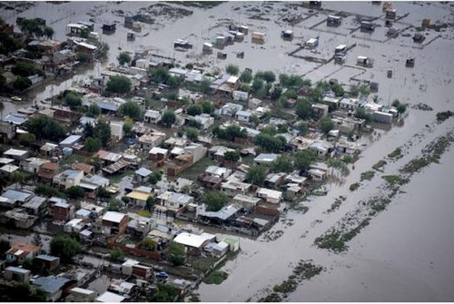
Historic Flooding in Argentina

Major cleanup efforts are underway in Argentina this weekend after major flooding occurred in the city of La Plata (pop. 250,000), just east of Buenos Aires. In some areas of La Plata, over 150mm fell in less than a 24 hour period causing for some flash flooding when the city’s sewers simply could not keep up. The reason for so much rain over one area can be attributed to a nearly stationary low pressure system over Argentina, south-west of Buenos Aires. Moist air from the South Atlantic was drawn in and the near stationary thunderstorms stayed over La Plata for over ten hours, beginning April 1st, lasting through April 2nd.

La Plata flooding

Aerial image of one of La Plata’s hardest hit areas. (Source: Reuters)

Flooding caused whole neighbourhoods to be submerged and people had to escape from their houses through the roof as floodwaters rose up to three feet. At one point, three million people were without power across Argentina because of the heavy rains. Some 2,200 residents of La Plata had to be evacuated. Unfortunately, 54 people have died from this event and there are still around 20 people missing. The property damage is extensive and is still being calculated but is likely to be in the hundreds of millions.

Elsewhere around the world:

  • There has also been severe flooding in Eastern China and Taiwan due a series of low pressure systems that brought heavy rain to an already saturated soil base.

  • This week will likely bring another multi-day, severe weather outbreak in the southern half of the US; from the Southern Plains into Dixie Alley, as a large trough digs across the region and warm, moist air from the Gulf of Mexico clashes with it.