Beautiful Weekend Ahead

The Red River Valley will receive a second shot of summer this weekend as warm air floods over the Prairies underneath an upper ridge.

500mb Winds valid Friday evening

500mb wind speeds valid this evening. A large upper ridge will bring warm weather to the Eastern Prairies.

Temperatures aloft continue to climb as an upper ridge advances eastwards across the Prairies. As a result, we’ll see a beautiful weekend ahead across the whole Red River Valley. Sunshine will dominate the skies over the next few days as temperatures climb into the low-to-mid 20’s. We’ll see highs near 23 or 24°C across the Red River Valley today, while things will really heat up tomorrow with highs closer to 26 or 27°C. Some cloud will begin to move into our region on Sunday ahead of an incoming system, which will limit our high to the lower 20’s, probably around 22 or 23°C.

Enjoy a nice summer-like break this weekend to our fall weather.

Warmer Weather Set to Return to The Red River Valley

After a prolonged and sudden stretch of normal to below-normal temperatures, warmer weather is on it’s way for Winnipeg.

500mb Winds valid Wednesday Evening

500mb wind speeds valid for this evening. Of note is the advancing upper ridge (denoted by the blue squiggle) over British Columbia.

The long-wave trough that has remained solidly parked over the Eastern Prairies over the past week is finally pushing off to the east, allowing a building upper ridge over British Columbia to spread eastwards into the Prairies and bring with it some milder Pacific air. With an incoming upper ridge, our chance for precipitation over the next few days is pretty much nil. We’ll see temperatures climb to about 17°C today, which will be a couple of degrees above our normal daytime high of 15°C for this time of year. Things warm up on Thursday as a warm front pushes through and we climb to a high of 23°C. Temperatures will remain in the low 20’s right through the weekend under sunny skies.

A Dry End to September

Rob put up a great summary on the precipitation situation for Southern Manitoba this month.

As of [September 24, 2012], only 4 mm of rain has fallen at Winnipeg airport this month, with no precipitation forecast all this week through the end of the month. If so, September will end up as the 2nd driest September on record in Winnipeg since records began 140 years ago in 1872.

I highly recommend you head over and read the brief summary Rob put up. It continues to look like we’ll be dry through the end of the month, so there’s a very good chance that Winnipeg may see it’s second driest September on record. We’ll have a complete summary for the month of September on Monday, October 1st in addition to our regular post.

Fall Weather

Fall has officially begun and, rather fittingly, fall weather is in store for the next few days.

High pressure will be in place over much of Manitoba for the first part of the week

High pressure will be in place over Manitoba for the first part of the week

Temperatures for the first few days of this week are expected to be around or slightly below normal. Monday, Tuesday, and Wednesday will all have high temperatures in the low to mid teens (normal high is 16C). Monday will have a cool north wind, but on Tuesday and Wednesday the wind should not be much of a factor. No notable precipitation is expected for the first half of this week as we remain under a surface ridge of high pressure.

Models have been hinting at some warmer weather towards the end of this week into next weekend. As the high pressure system from earlier in the week moves off to the east it appears that a southerly flow will develop over Southern Manitoba, allowing us to see some more above-normal weather before the end of the month.

Elsewhere in Weather News: September 22nd, 2012

Wildfires Sparked by Dry Lightning Affect Pacific Northwest

A couple large wildfires in the state of Washington have been burning for the past week or so and continue to grow in size. The fires, located in the central and southwestern part of Washington, were sparked by dry lightning a few weeks ago but have only started significantly growing in size this week. The main reason as to why these fires have now become large and uncontrolled can be attributed to the very dry conditions and warm temperatures on the west coast this past month.

Washington wildfires

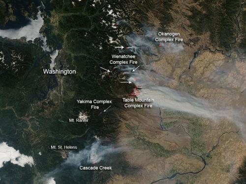
Picture of various wildfires across Central Washington. (Source: NASA)

Currently, the largest fire in the state is the Wenatchee Fire Complex which covers around 16,000 hectares, is around 25% contained, and is being battled by over 2,000 firefighters. The second complex of fires, Table Mountain Complex, poses the highest level of threat to residents – causing 1,250 residents to evacuate and currently putting 750 homes at risk. Approximately 700 firefighters were currently at work on that specific fire complex which was only 5% contained as of Thursday. Smoke that has been slowly wafting further away from the fires, has started to affect surrounding communities in Central Washington thereby prompting the issuance of air quality advisories.

Wildfire

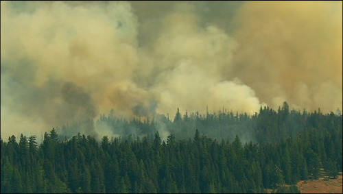
One of the numerous wildfires raging across Central Washington. (Source: KIMATV)

The reason for the unseasonably warm temperatures in Washington and the rest of the west coast this week (approximately 6°C above average) can be linked to a strong ridge of high pressure that has been in place since the start of this week. It appears that the balmy temperatures will stay put through the weekend. Early next week, a weak upper-level disturbance is predicted to slide through the area which could bring some precipitation with it to alleviate the threat of the fires, although it could also cause more trouble than good if more lightning strikes come with the system.

Ridge

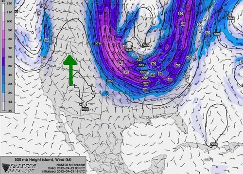
Ridge over the west coast (indicated with green arrow) with 500mb winds and heights. (Source: Twisterdata)