Elsewhere in Weather News: September 29, 2012

Typhoon Jelawat Forecast to Weaken Before Impacting Japan

Typhoon Jelawat remains at very strong intensity despite weakening from its previous status as a super typhoon. Earlier this week Jelawat had maximum sustained winds of 220km/h near its centre, which would classify it as a category four hurricane by north american standards. The storm currently has maximum sustained winds of 145km/h (as of Friday afternoon), the equivalent of a category two hurricane.

Satellite image of Jelawat on Thursday morning when it was heading toward Taiwan with 155mph sustained winds

Satellite image of Jelawat on Thursday morning when it was heading toward Taiwan with 155mph sustained winds. (JMA/NOAA) – via Washington Post (see sources)

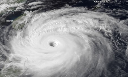
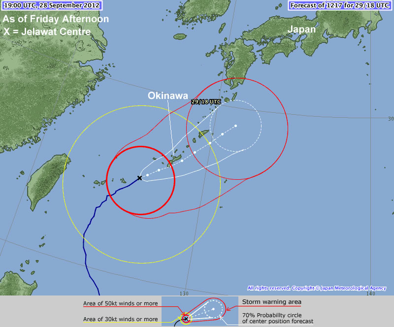
Jelawat is presently located near Okinawa and is moving in a north-easterly direction toward Japan, weakening the further north it moves. According to the Japanese Meterological Agency Jelawat will impact the Ryukyu Islands, including Okinawa, today before moving toward the Japanese mainland late today into Sunday.

Jelawat's Forecast track by the JMA

Jelawat’s Forecast track by the JMA

Thus far Jelawat has not caused any devastating damage, owing to the fact that it has not yet impacted any large land masses. Some damage was reported on Lanyu (Orchid Island), located just off Taiwan’s south-eastern coast. No casualties have been reported on Lanyu, but the harbor, gas station, and supermarket were reportedly destroyed. There may be more damage as this typhoon moves over the more heavily populated Ryukyu Islands this weekend.

Sources: http://www.taipeitimes.com/News/front/archives/2012/09/29/2003543923, http://www.hko.gov.hk/wxinfo/currwx/tc_gis_e.htm, http://www.washingtonpost.com/blogs/capital-weather-gang/post/typhoon-jelawat-closing-in-on-okinawa-japan-nadine-becomes-hurricane-again/2012/09/28/c0f6844c-097b-11e2-a10c-fa5a255a9258_blog.html

Beautiful Weekend Ahead

The Red River Valley will receive a second shot of summer this weekend as warm air floods over the Prairies underneath an upper ridge.

500mb Winds valid Friday evening

500mb wind speeds valid this evening. A large upper ridge will bring warm weather to the Eastern Prairies.

Temperatures aloft continue to climb as an upper ridge advances eastwards across the Prairies. As a result, we’ll see a beautiful weekend ahead across the whole Red River Valley. Sunshine will dominate the skies over the next few days as temperatures climb into the low-to-mid 20’s. We’ll see highs near 23 or 24°C across the Red River Valley today, while things will really heat up tomorrow with highs closer to 26 or 27°C. Some cloud will begin to move into our region on Sunday ahead of an incoming system, which will limit our high to the lower 20’s, probably around 22 or 23°C.

Enjoy a nice summer-like break this weekend to our fall weather.

Warmer Weather Set to Return to The Red River Valley

After a prolonged and sudden stretch of normal to below-normal temperatures, warmer weather is on it’s way for Winnipeg.

500mb Winds valid Wednesday Evening

500mb wind speeds valid for this evening. Of note is the advancing upper ridge (denoted by the blue squiggle) over British Columbia.

The long-wave trough that has remained solidly parked over the Eastern Prairies over the past week is finally pushing off to the east, allowing a building upper ridge over British Columbia to spread eastwards into the Prairies and bring with it some milder Pacific air. With an incoming upper ridge, our chance for precipitation over the next few days is pretty much nil. We’ll see temperatures climb to about 17°C today, which will be a couple of degrees above our normal daytime high of 15°C for this time of year. Things warm up on Thursday as a warm front pushes through and we climb to a high of 23°C. Temperatures will remain in the low 20’s right through the weekend under sunny skies.

A Dry End to September

Rob put up a great summary on the precipitation situation for Southern Manitoba this month.

As of [September 24, 2012], only 4 mm of rain has fallen at Winnipeg airport this month, with no precipitation forecast all this week through the end of the month. If so, September will end up as the 2nd driest September on record in Winnipeg since records began 140 years ago in 1872.

I highly recommend you head over and read the brief summary Rob put up. It continues to look like we’ll be dry through the end of the month, so there’s a very good chance that Winnipeg may see it’s second driest September on record. We’ll have a complete summary for the month of September on Monday, October 1st in addition to our regular post.

Fall Weather

Fall has officially begun and, rather fittingly, fall weather is in store for the next few days.

High pressure will be in place over much of Manitoba for the first part of the week

High pressure will be in place over Manitoba for the first part of the week

Temperatures for the first few days of this week are expected to be around or slightly below normal. Monday, Tuesday, and Wednesday will all have high temperatures in the low to mid teens (normal high is 16C). Monday will have a cool north wind, but on Tuesday and Wednesday the wind should not be much of a factor. No notable precipitation is expected for the first half of this week as we remain under a surface ridge of high pressure.

Models have been hinting at some warmer weather towards the end of this week into next weekend. As the high pressure system from earlier in the week moves off to the east it appears that a southerly flow will develop over Southern Manitoba, allowing us to see some more above-normal weather before the end of the month.