Record Early Snowstorm Hits Northern States
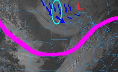
The same powerful low pressure system that brought the first significant snowfall of the season to Southern Manitoba dropped copious amounts of snow south of the border. A surface low pressure system that was moving in a north-easterly fashion combined with a deepening upper low through the area resulted in a record-breaking early winter storm this past week in North Dakota and Minnesota.
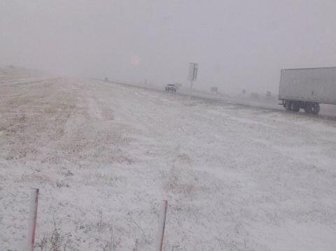
Impressive snowfall totals were recorded in Northern Minnesota and North Dakota in the wake of the storm. Numerous cars were spotted in the ditches and tractor-trailers jackknifed in Northern Minnesota on Friday, due to treacherous road conditions. Around 3,000 people were out of power in the two states on Friday afternoon in the hardest hit areas. Woodridge, MB to Thief River Falls, MN received the heaviest bands of snow. Below lists some of the impressive amounts of snow accumulation recorded in Minnesota and North Dakota, as per reported by the National Weather Service:
- Badger, MN (30 minutes south of Piney, MB): 30-36cm
- Roseau, MN: 18cm
- Grand Forks, ND: 9cm – A record for largest amount of snow to fall this early in the year (old record: 5cm)
- International Falls, MN: 4cm – Also a record for the largest amount of snow to fall this early in the year (old record: 1.5cm)
(The remainder of the reports as of 3pm, Friday afternoon can be seen at http://www.crh.noaa.gov/news/display_cmsstory.php?wfo=fgf&storyid=87914&source=0)
This snowfall brings to a close (for now) the extreme fire danger in North Dakota and Minnesota whose conditions were similar to Southern Manitoba – extremely dry and windy. The Karlstad fire in Minnesota on October 3rd was fanned by severe 65km/h winds and drought conditions. In total, 31 buildings were destroyed; thankfully, no one was hurt.

As the low pressure system continues to move further north-east, areas in Northern Ontario such as Timmins and Geraldton will experience their first snowfall of the year.