Typhoons and Hurricanes Spin Up in Northern Hemisphere
Mother Nature has been very busy world-wide, wreaking havoc of all forms this past week. The Deluth floods, tornadoes in South Dakota, and as reported in today’s EIWN post—typhoons and hurricanes have spun up in the North-West Pacific and North Atlantic basins.
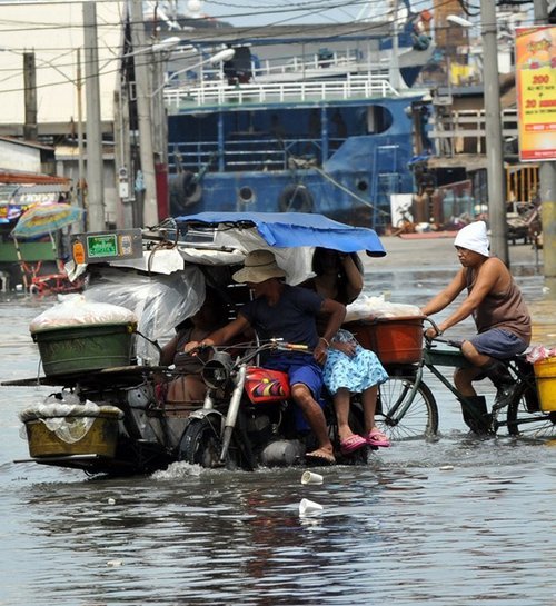
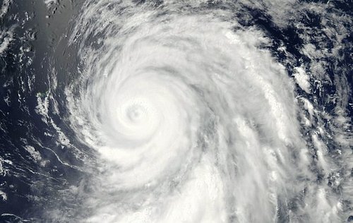
This past Sunday, June 17th, typhoon Guchol (known as Butchoy by the Philippines) gave a scare to the Philippine islands’ residents as it scooted a couple hundred kilometers to the east of the islands while racing northwards. Minor storm surge and the outer spiral bands of Guchol brought heavy rains and flash floods to the area. Making matters worse was the fact that the monsoon winds were occurring, feeding warm, moist, air from the equator. The streets in Manila were flooded requiring people to walk through waist-high water to reach their destination. Landslides caused by the heavy rains were also reported in the region. The eye of the typhoon didn’t hit land in Manila however; it kept roaring in a northerly fashion towards Japan where it finally made landfall on Tuesday. Intense winds were recorded above 200km/h near the eye of the storm. Flash-flood conditions existed in areas where the typhoon made landfall and near the core, through the more mountainous regions of Japan. About 80 people had injuries relating to the storm and one person died when his house was torn apart by the vicious winds. Since then, Guchol has been downgraded to an extratropical storm and has weakened significantly as it’s path continues over land and it moves away from the warm sea surface temperatures that gave it it’s energy.
Streets of Manila completely underwater. (Source: Ted Aljibe/RT)
Image of Guchol racing towards Japan in the North-West Pacific Ocean. (Source: NASA)
Meanwhile, in the North Atlantic, the third-named storm of the year, Hurricane Chris, formed far off to the south-east of Newfoundland, in the middle of the North Atlantic but poses no threat to land. This hurricane is only the second most northerly hurricane in the history of record keeping. It managed to form in the 22°C waters of the North Atlantic Ocean, bringing us to wonder whether it developed due to global warming or is just a glimpse the planet’s extremes?
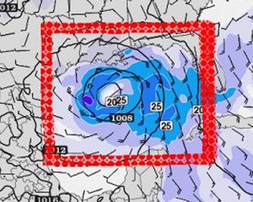
Later this weekend various models are hinting at a tropical storm forming in the southern half of the Gulf of Mexico. Other than that, models are in disagreement and all over the place regarding which way future “Debby” will be heading.
NAM’s projection of where Debby will be Sunday morning. (Source: TwisterData/AWM Model Viewer)
5 years ago today, Canada’s first official F5 tornado touched down in the small community of Elie, Manitoba. It destroyed several homes, completely sweeping them away from their foundations. Trees were debarked, vehicles were destroyed, and the town’s flour mill was damaged. While it was originally rated an F4 tornado, after extensive investigation by Environment Canada it was upgraded to the country’s first F5 tornado, with estimated wind speeds exceeding 420km/h.
The following is a personal account from a friend of mine, storm chaser Justin H., who was out that day and witnessed the tornado first hand. I thought it fitting that on the 5th anniversary of the event we would have an account of the event from somebody whose enthusiasm for severe weather goes nearly unmatched. Justin, thank you for writing this and contributing to the site; I hope that you all enjoy reading about his experience.
A Personal Account of the Elie, MB Tornado
Written by Justin Hobson
I remember this day like it happened just yesterday. This tornado event will be forever etched in my memory as long as I live. The sights, the sounds, the smells. I still remember shifting my head up to take in the full extent of what was later known as Canada’s strongest documented tornado.
Conditions were favorable for severe thunderstorms on June 22nd, 2007 over much of Southern Manitoba as winds turned and increased with height in combination with high heat and humidity. These conditions favored rotating thunderstorms (Supercells). Storms were supposed to form along a cold front that was oriented from NE to SW across WesMan. A warm front was draped to the east through the Interlake with a surface trough dissecting the warm sector in half oriented north-to-south through Portage La Prairie. The warm sector was capped (inhibiting convection) for much of the day, but a tornado threat existed from the get-go if the cap were to be removed. The cold front was the definite trigger for storms but what was unusual about this day was that the combination of gravity waves originating from the MB Escarpment, horizontal convective rolls within the boundary layer, and moisture convergence allowed the cap to erode before the cold front arrived paving the way for explosive supercell development around 5:30 pm local time (2230 UTC) just to the NW of Elie.
I left work that afternoon with tornado chances fading because of the capping issues that were present all afternoon. I had planned to chase this setup for a week prior (models did a decent job in advance) so I was feeling upset as I was looking forward to chasing in my backyard around Winnipeg. As I left downtown and headed down Highway 3 towards home, I could see what looked to be like a volcanic eruption to the NW of my location. There was explosive cell development occurring southeast of Lake Manitoba. I continued home and was starting to get excited. The first thing I did upon arriving at my house was check the radar on weather office. Woodlands radar was already detecting this cell with some returns starting to show up NW of Elie. I said to myself, well I’ll pack up my gear in the mean time and if the next scan gets better…I’ll go for it. I grabbed my Dad’s camera, a baseball cap and went back to my computer. I clicked the reload page button a few times before the new image displayed its true beauty. A supercell was being born. It was in the right spot within the area of low pressure, and it was in the tornado zone that was analyzed earlier that afternoon.
I headed out, this time on Highway 2 towards Starbuck, Manitoba. Once I arrived in Starbuck I started to get rained on fairly heavily by the storm as I shifted directions and headed north out of town. I thought to myself, oh great the cell has already collapsed. I continued pressing north. Visibility was reduced as the rain got heavier and heavier. Some small hail (pea-sized) began hitting my car as I arrived at a crossroad that would take me west towards Elie (1 mile south). I headed towards Elie as the rain/hail began to ease. What I saw next was remarkable. A wall cloud! I couldn’t believe it…this was the first wall cloud I’ve seen that showed tor’ific potential. I parked on a gravel road just to the south of Elie, I placed my camcorder on the roof of my vehicle, hit record and watched.
Within minutes funnels began to form. I was so excited! A funnel would form, go back up, then a new one would form and reach a little further towards the ground. This happened several times before a long rope funnel reached toward the ground. My first tornado! I snapped some pictures and called Environment Canada to report what I was witnessing. Within minutes, the tornado grew larger, then smaller again, and then it really got its act together. It grew into a large cone tornado that almost looked blue from my vantage point. This was truly amazing. I couldn’t believe what I was witnessing.
“Her last words to me were “Oh…well…don’t die!”
My heart was racing…I had knots in my stomach (like what you get just before they pull the trigger at a 100m race). I was on the phone with Environment Canada reporting the change in shape and size to a forecaster named Curtis. Once I called that report in, I was on the phone with some friends as well as my sister Bryanne. She told me she heard that there was a tornado near Winnipeg. I told her I was right beside it near Elie…and that I thought that the tornado would hit the town…her last words to me were “oh…well…don’t die!” I put the phone down and took in the sight. I couldn’t believe what I was seeing…after 10 years of being passionate about severe thunderstorms…and after 4 years of chasing…I’ve finally done it.
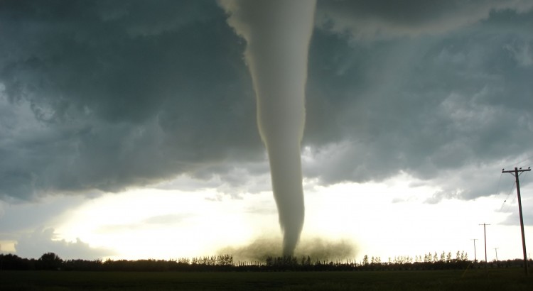
Video of Canada's first F5 Tornado (upgraded from F4) taken from one mile away that severely damaged the western part of Elie, Manitoba on Friday June 22nd, 2007
I vividly remember how calm it was and was very observant to what was occurring all around me. I remember hearing Killdeer birds chirping away, as well as frogs in the nearby ditches. I also remember mosquitoes flying around and buzzing in my ear, and I can also remember hearing the constant low rumble of thunder to the east of my location. All of this was occurring while the tornado peacefully and slowly twisted its way across open fields towards the southeast. A passerby named Jason stopped by and was just as excited as I was. We exchanged a few words and I even snapped a picture of him with the tornado in the background. I obtained his email address to forward him the picture later on, and he was off to check on his house…he thought it may have been hit. By the time he left, the tornado grew larger and became darker in appearance. I could hear the tornado now. The only thing that resembles the sound in the real world is that of a waterfall. It was like someone was turning up the volume of this ‘waterfall’ as the tornado sluggishly crept closer.
“The tornado continued to hurl debris which could now be seen very high up into the sky wrapping around the tornado.”
At this time the tornado wasn’t growing larger…it appeared stationary for a brief time before it suddenly began moving to the right (East). Shortly after shifting its track I could here different sounds as large pieces of debris were being hurled around the circulation. It was hitting the town. I began to feel uneasy. Lightning started to grow more intense so I fled to my car with my camera and continued to record the tornado. Power flashes occurred for a brief moment as the tornado severed power poles while impacting the neighborhood on the west side of town. A friend named Chris called me and said that he heard there was a tornado near Elie and that the clouds over his head in SW Winnipeg were crazy (Mammatus likely). I told him I was near Elie and the tornado was hitting the town and that I would call him back later. He said to stay safe and hung up.
Aerial Shot of the Damage from the Elie Tornado
A series of photos showing some of the damage that occurred in the west side of Elie, MB.
Photograph of the mature phase of the Elie Tornado (credit: Shanna65
A shot of the Elie tornado impacting the west side of town. A van is visible to the right of the grain elevator.
The tornado continued to hurl debris which could now be seen very high up into the sky wrapping around the tornado. The tornado was moving to the left now (West) where it grew thinner, and thinner, then suddenly disappeared. It was over? I wanted to get out of the area just in case the tornado redeveloped over my head. Shingles and insulation began to hit the vehicle and land all around the highway as I pressed north towards town. As I entered the town I could see a police car, an ambulance and what looked to be two dated fire trucks heading down a residential street towards the area that was impacted. There were several local residents rushing to the scene so I didn’t enter the town.
Upon making that decision I looked to my West and saw another tornado. I quickly did a U-turn and began to record the tornado as I drove back to the south towards Highway 2. The tornado was large and lasted for quite some time before becoming wrapped with rain and dissipating. This tornado was later rated an F3 after devastating a farmstead near the town of Oakville.
Well that is my story of the Elie, Manitoba, F5 tornado that occurred on June 22nd, 2007. This is the first time writing a detailed personal account of the event and it gave me welcomed goose bumps in doing so. I hope you enjoyed it!
Justin Hobson has recently completed a masters thesis on the F5 tornado in Elie. You can view it here.
After an extremely cloudy, soggy two-week streak of weather over the Red River Valley, sunshine is in the cards. Lots of it.
Several days of warm temperatures and sunshine are expected across Southern Manitoba, a welcome change from the cloudy, wet weather that has persisted the past few weeks. Photo: Brad V.
An upper ridge will build in over the Central Prairies through the weekend, bringing plenty of sunshine and warm temperatures to the Red River Valley. Daytime highs will sit near 25°C today and tomorrow. Highs will drop a little bit on Sunday as some cooler air slides down from Central Manitoba, giving us a daytime high near 22 or 23°C. Overnight lows through the next few days will range from 9-14°C.
More heat and humidity is forecast to build in through the first half of next week, pushing daytime highs up into the high 20’s and overnight lows into the high teens. The upper ridge is forecast to break down in the second half of next week, bringing the risk of stormier weather back to Winnipeg.
One more day of showers is in store for Winnipeg as another upper low tracks across the province before conditions finally begin to improve as the long-wave upper trough that has been quasi-stationary over the Prairies shifts off to the east and upper ridging begins building in.
6-hour accumulated rainfall for Thursday afternoon from the GEM-REG. Showers with a slight chance of a thundershower are expected through much of Southern Manitoba today.
Another low will track across Southern Manitoba today, bringing with it more cloud and a chance of showers. This system brought widespread thundershowers to Alberta & Saskatchewan yesterday with multiple sightings of funnel clouds as well. Activity will be more subdued over Manitoba today as the system won’t have quite as much energy to work with as yesterday; in general the clouds should break up over the RRV a little this afternoon with scattered showers developing over SW Manitoba and pushing eastwards through the afternoon. Rain will likely be hit and miss as the disorganized mass pushes eastwards. Showers will move into the Winnipeg area by mid-afternoon and will push out/diminish in the early evening as daytime heating diminishes. There’s a slight chance for a thundershower or two, but that chance is marginal at best.
As the low moves off into NW Ontario tomorrow evening, it will mark the transition to a markedly different weather pattern. Through the day on Thursday, upper ridging will begin to build it’s way into the Prairies. We’ll finally see the sun again on Thursday as temperatures climb into the low 20’s across the RRV. There’s a slight chance of some showers/thunderstorms over SW Manitoba and the RRV as a shortwave slides down through the area. After that, it’s all sunshine as the upper ridge continues building into our area. Temperatures should push into the mid-20’s for the weekend with plenty of sunshine. Finally, some time to dry out!