Winnipeggers: get ready for a shock. The next few days are going to be startling chilly with daytime highs over 10°C below normal and overnight lows over 5°C below normal. Another thing that will be noticably absent other than warmth? The sun will make only a few rare appearances over the next several days as another system pushes into Southern Manitoba, bringing another round of rain and thunderstorms to the Red River Valley.

850mb temperatures vaild at 00Z Sat. May 26 (Friday evening). An elongated cold trough is sweeping across Southern Manitoba, bringing 850mb temperatures in the -2 to -5°C range.
This cool weather has brought late-season (or is it early-season now?) snow to several communities over Western Manitoba including The Pas, Flin Flon and higher elevations over SW Manitoba (Duck Mountain & Riding Mountain areas). A few leftover flurries will scoot across the Interlake this morning and exit out of the province. The Red River Valley wil be spared, however we’ll be stuck under low clouds with a daytime high that struggles to make it to 10°C.
Tonight, a widespread frost potential exists over the most of Southern Manitoba. As a surface ridge moves into our area, winds will abate and we’ll see the cloud begin to break up a bit this evening. The greatest potential for frost looks to be over Southwestern Manitoba in the Virden, Melita, Pilot Mound & Brandon regions. Further east, here in the Red River Valley, some scattered clouds and a bit of moisture trapped in the valley should help temperatures stay above freezing, with overnight lows in the 2-3°C range. Areas outside the City of Winnipeg in the RRV certainly have a slight risk of a light frost. Winnipeg will likely be frost-free, with an off-chance of patchy frost in outlying areas near the Perimeter Highway.
Saturday will be our transition day with temperatures reaching 13-14°C and cloud streaming northwards from the Dakotas with the next incoming system. Rain will push up towards the International Border by morning, likely staying in the States but certainly poses the chance of a few showers along the border. The rain will stay near the border until Sunday, when the next big northward push arrives.
 ](https://img.skitch.com/20120525-mkq1sh9w3aa3twa7r6stuq9j2q.png)
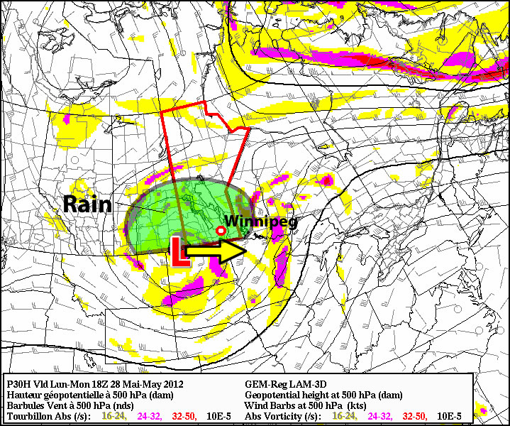
Precipitation accumulation from the GEM-GLB model for Saturday morning to Monday morning. A broad swath of rain is forecast to fall from extreme SW Saskatchewan through Southern Manitoba.
And what a push it will be! Showers and thunderstorms will rapidly develop into an expansive area of rain on Saturday night, slowly pushing northwards across the Red River Valley. Most regions across Southern Manitoba should expect rain to start fairly early on Sunday and last through most of the day. Rain will likely taper off from west to east overnight, with only a few wrap-around showers moving across the RRV on Monday. It’s still early to give accurate estimates of rainfall totals for this next system, however in general, most regions across Southern Mantioba look to see at least 10-20mm of rainfall, with the potential for nearly 30mm in some areas of the RRV if some embedded convection can get going. Regions of Southwestern Manitoba that end up north/northwest of the main upper low track will see higher amounts as well, with 20-30mm of rain likely. This isn’t the best news for this year’s Teddy Bears Picnic, but hopefully shouldn’t dampen spirits too much at an event that has, historically, had to deal with some pretty awful weather. Wait, I’m getting deja vu…
Conditions look to improve through the middle of next week, with temperatures pushing back towards the 20°C mark and some sun finally making an appearance. That’s a ways to go, though, so grab your slippers and heat up some soup! We have some great stay-inside weather coming up. We’ll be sure to keep a close eye on this system and provide updates in the comments.