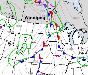
A low pressure system tracking through western and central Manitoba will bring unsettled weather, cooler temperatures and windy conditions to the Red River Valley this weekend…but not before one more beautiful day.

Conditions will be fairly uniform across the Red River Valley today with plenty of sunshine, highs near 20°C and a stiff southerly wind blowing at 40 to 50km/h. It’s a fitting end to another simply beautiful, and above normal with regards to the temperature, week. Tonight, a low pressure system will eject out of southeast Saskatchewan across Parkland Manitoba and into the Interlake. Associated with this low is a very strong 40kt low-level jet (LLJ), however a lack of moisture and unimpressive mid-level lapse rates should erase any concerns (or hopes) of nocturnal convection.
A cold front will sweep across the Red River Valley on Saturday morning, bringing a chance of showers to most regions; indications are that areas east of the Red River will see a greater chance of a shower or two than areas west. After the passage of the cold front, the entire RRV will be left with a fairly strong westerly wind and cloudy skies.

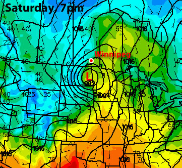
The wrap-around precipitation will begin to move into the RRV on Saturday night, coincident with colder air diving southwards on the backside of the low. Current indications are that the precipitation will fall as snow and that the northern half of the RRV has a much greater chance of seeing flurries than the southern half. The low continues to lift NE through the day Sunday, pulling the wrap-around northwards with it and out of the RRV. It will be a struggle between the main area of lift pulling north and remnant moisture and instability in the cooler air left in the RRV. Most areas in the RRV will likely see a little bit of snow on Sunday, however the only areas that might accumulate a cm or two would be north of Morris.
All in all, we’re being spared with this system, as large amounts of precipitation are forecast from the Moose Jaw/Regina, SK region along a line NE to Swan River and The Pas. The GEMGLB is currently painting up to 75mm of precipitation, which if that were to all fall as snow would likely end up as 1-2 feet of the white stuff. We’ll see how much actually falls, though, as the GEMGLB can have problems with convective feedback in situations where embedded elevated convection is a possibility along a warm front. Anyone planning to travel to Saskatchewan today or on the weekend should make sure they check road conditions and weather forecasts for cities/towns along their route before they leave.
After that things clear out for the start of next week and our temperatures rebound back into the low teens by midweek. Things are looking like we’ll have continued sun and warm temperatures into next weekend as well.