After a period of unprecedented March warmth, it is time for a dose of March weather reality. Our first significant spring weather system will roll through Southern Manitoba early this week. This system will follow what has been a cool, but fairly seasonal weekend. Hopefully you are starting to get a feel for what spring is really like in Southern Manitoba.
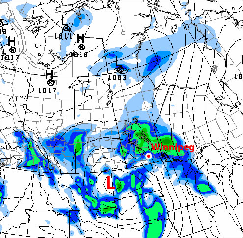
The GEM model shows light rainfall over Southern Manitoba at 1am on Tuesday with more precipitation developing over the Dakotas
A strong south-easterly wind will develop out ahead of the approaching low pressure system on Monday. Wind speeds will generally be on the order of 40km/h gusting to 60km/h. The combination of strong wind speeds and mainly cloudy skies will mean that high temperatures in Southern Manitoba will stay stuck in the mid single digits on Monday. During the day on Monday light shower activity, as well as the odd embedded thunderstorm, will develop across Southern Manitoba. Accumulations from these showers are expected to be light, with rainfall amounts of only a couple millimeters expected.
This weather system will really begin to get going on Monday night, with strong to severe thunderstorms expected to develop across the Dakotas. These thunderstorms will be triggered by a strong area of lift associated with the low pressure system. Additionally, a powerful low-level jet stream will provide a secondary source of lifting and a strong moisture feed. A low-level jet stream, or LLJ for short, is a “river” of very strong wind about 5000 feet above the ground. Wind speeds in the LLJ can exceed 100km/h less than one mile above the surface. The result of the LLJ on Monday night will be the rapid movement of air into the Northern US Plains and Southern Manitoba from more southern parts of the United States. The movement of warmer, more moist air into our region along the LLJ will provide support for some stronger storms on Monday night. The potential for severe thunderstorms certainly exists on Monday night in portions of North and South Dakota. It is unlikely that we’ll see any severe storms in Manitoba, but some stronger cells with gusty winds and hail may sneak across the border late on Monday or early on Tuesday.
The thunderstorms that develop across the Dakotas on Monday night will eventually move into Southern Manitoba during the overnight hours regardless of their strength. Besides the potential for gusty winds and hail as outlined above, many of the storms moving up from the south will produce locally heavy rainfall. Widespread accumulations of 5 to 10mm are expected on Monday night into Tuesday morning over Southern Manitoba, but locally heavier amounts are possible where thunderstorms pass by.
The bulk of the precipitation will be over for Winnipeg and the Red River Valley by Tuesday morning. Only light showers will persist during the day on Tuesday. However, residents of Western Manitoba won’t be quite as lucky. Rain will change to snow in Western Manitoba on Tuesday morning. Snow will continue over portions of Western Manitoba through the day on Tuesday. Total accumulations by Tuesday evening will generally be in the 2 to 6cm range in Western Manitoba. However, areas at higher elevations, such as Riding Mountain National Park, may see 10cm or more by late in the day on Tuesday. It is possible that Winnipeg and the Red River Valley could get a bit of snow on Tuesday evening. If any snow does fall it will be light in nature and won’t accumulate to much, if anything. Even if Winnipeg does get a dusting of light snow on Tuesday night it will be gone by Wednesday, as high temperatures will remain well above zero through mid-week.
Storm total rainfall amounts in Southern Manitoba will vary from place to place. Some estimates are listed below:
- Winnipeg: 10 to 15mm
- Steinbach: 5 to 10mm
- Brandon: 10 to 20mm
- Portage la Prairie: 10 to 15mm
*Note that the above forecasts have a large margin of error given that thunderstorms will largely determine where the heaviest rain will fall.
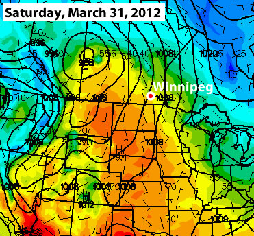
The GFS model temperature prediction for next Saturday – the yellow/orange boundary represents temperatures near 20C (image courtesy of College of Dupage)
Long-range models don’t show any sign of winter returning to Southern Manitoba. The current run of the GFS model (a short to medium range model) shows temperatures potentially returning to the 20C mark in Southern Manitoba by next weekend. While this may or may not actually happen, it is a sure sign that temperatures will remain above-normal through the end of the month.
Elsewhere in Weather News
Hail Storm – A Winter Wonderland
This past Friday, a severe thunderstorm rolled through Indiana bringing with it strong winds, heavy rain and frequent lightning. What was so unusual about this storm was that it also dumped four inches of hail during the course of 15 minutes – which is considered quite a lengthy time for a hail storm. The severity of the hail storm was more than enough to wreak havoc on the highways. Hail drifts were reported to be a foot high in some areas and authorities closed a section of the interstate in the area due to cars getting stuck in ruts and several accidents being reported. The road conditions were winter-like as cars hit the ditch and residents described the scenery as a “hail blizzard”. After four hours, snow plows cleared away the remainder of the hail that was not melted yet and the interstate was reopened. The hail was not significant in size as it came down, only measuring up to dime-size, causing no property damage in the area.
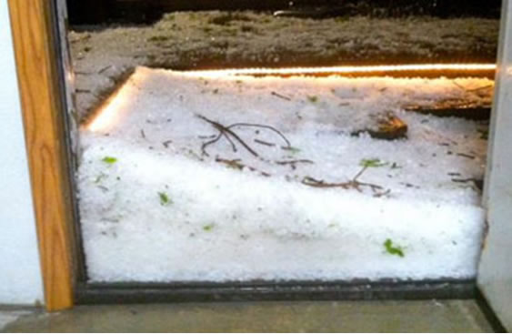
Hail drift in the doorway, taken in Fountaintown, IN (just east of Indianapolis). (Source: WTHR news – Jessica White)
The line of storms that was associated with a cold front moving through the region also prompted tornado watches in the Midwest, as several weak tornadoes touched down in Illinois, Indiana and Kentucky. Since then, the slow moving cut-off low brought more potent storms to the Southeast US on Saturday. It has now moved out over the Atlantic and is no longer a threat to North America.
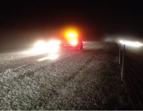
Interstate 74 totally covered by hail, with ruts. Snowplows had to come in and clear away the hail. (Source: WTHR news)
Elsewhere in Weather News has been provided by Matt