End of Weekend Brings Colder Weather

Winnipeg will see temperatures slowly drop towards seasonal values as several weak disturbances moving through the region draw cooler air southwards.

A blanket of low cloud entrenched over the region will keep temperatures seasonably mild in Winnipeg today. The city will see temperatures climb back to around -2 °C with light southeasterly winds. There’s a small chance of some flurries later today into the evening as a weak low moves across the region. The cloud cover should break up a bit tonight with light northeast winds and a low near -12 °C.

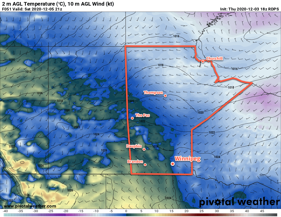
A ridge of high pressure will move across the region on Saturday and keep winds light. Temperatures will again be seasonably mild with highs recovering to around -4 °C. The city will see partly cloudy skies through the day. An approaching low will spread cloud into the region on Sunday night as temperatures head to a low near -8 °C.

RDPS 2m Temperature Forecast valid 12Z Monday December 14, 2020
The coldest weather so far this season will arrive Sunday night as temperatures plunge into the -20s across most of Manitoba and Saskatchewan.

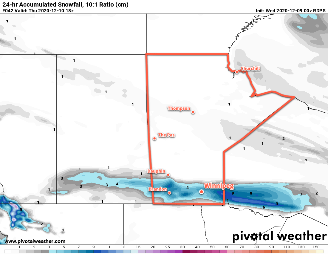
A low pressure system crossing the province on Sunday will bring cloudy skies to Winnipeg. Temperatures will start off seasonably mild with a high near -6 °C, but a cold front will sweep through the Red River Valley midday and bring breezy northwest winds of 30–40 km/h behind it. This cold front will give a small chance of some light snow, then begin ushering in a much colder air mass. The cloud cover will break up on Sunday night with temperatures heading to a low near -22 °C.

Long Range Outlook

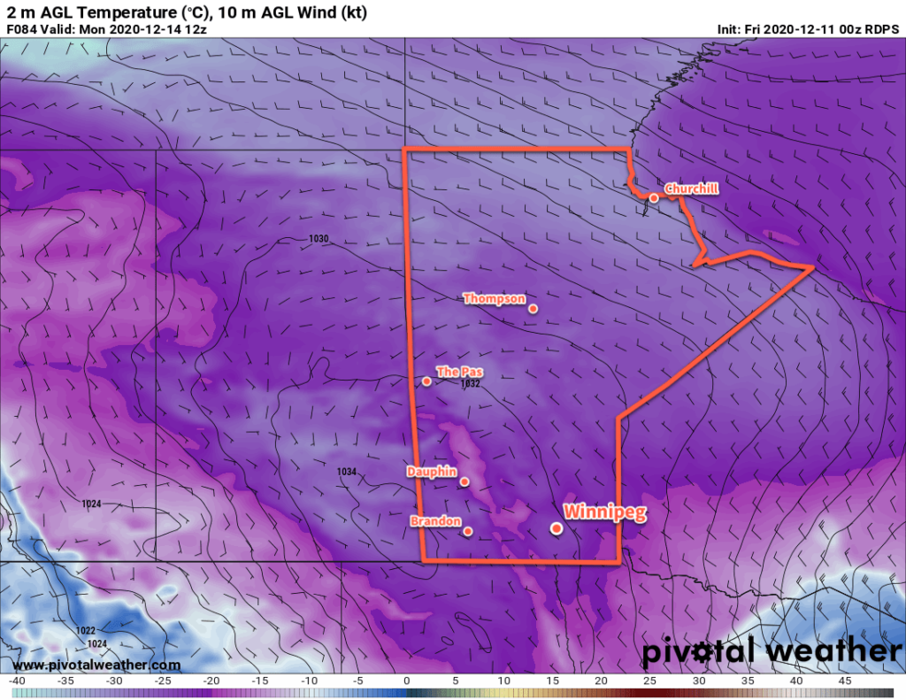
Winnipeg will start the new week with seasonably cold conditions, but by mid-week milder air pushes back into the region. It won’t be as warm as it has been, but highs could return to the mid-minus single digits.

Today’s seasonal daytime high in Winnipeg is -9 °C while the seasonal overnight low is -19 °C.

Clipper System Brings Winter Back to Winnipeg

After record-breaking warmth yesterday, a change in the weather is coming up as a clipper will bring snow and usher a much colder air mass into the region.

Today will still be fairly mild in Winnipeg with temperatures once again climbing above freezing. The city should see a high near +2 °C with clouds increasing this afternoon as a low crossing the Northern Plains pushes towards the region. Skies will cloud over this evening with light snow beginning overnight. Temperatures will dip to a low near -2 °C.

Accumulating snow will taper off by midday Thursday with 5–10 cm likely in the Winnipeg area. There’s a slight chance that the snow band from this low will end up a touch further south; that would put Winnipeg closer to 2–5 cm and the southern Red River Valley in the 5–10 cm range. After the main snow tapers off, flurries will linger as a cold front gradually slumps southwards into the region. Temperatures will reach a high near -1 °C with northwest winds climbing into the 20–30 km/h range. The flurries will taper off overnight as temperatures head to a low near -9 °C and winds ease.

RDPS 24hr. Snow Accumulation (at 10:1 SLR) valid 18Z Thursday December 10, 2020
Snow will move across southern Manitoba on Wednesday night and leave behind a swath of accumulations in the 5–10 cm range.

Friday will continue the cooling as more seasonal temperatures push towards the region. Mixed skies will persist through the day — there may be some occasional non-accumulating light snow — with temperatures climbing back to a high near -5 °C. Skies will be partly cloudy on Friday night with temperatures dipping to a low near -16 °C.

Long Range Outlook

A much colder air mass will settle into the region this weekend. Daytime highs are forecast to drop into the minus teens with overnight lows potentially dipping below -20 °C by Monday morning. Temperatures may moderate slightly, but near-seasonal temperatures are forecast to persist right through much of week.

Today’s seasonal daytime high in Winnipeg is -9 °C while the seasonal overnight low is -18 °C.

Temperatures Remaining Above-Normal in Winnipeg

Winter will continue to be MIA as daytime highs continue to climb above freezing this week.

Another broad upper ridge spreading across the Prairies will keep mild Pacific air in place over the region.

To start the day, Winnipeg may see a bit of cloud or fog. If it does show up, things should clear out relatively quickly and leave behind mainly sunny skies. Temperatures will climb to a high just above 0 °C. The city will see light westerly winds through most of the day. More cloud will spread through the region tonight with lows dipping to around -4 °C.

On Tuesday, the city will see a few more clouds as a trough moves across the region. Winds will pick up out of the west midday behind the trough into the 20–30 km/h range. Once those westerlies kick in, temperatures should jump nicely for the afternoon and reach a high near +4 or 5 °C. Skies will mostly clear tomorrow night with winds easing and a low near -3 °C.

RDPS 2m Temperature Forecast valid 21Z Tuesday December 8, 2020
All of southern Manitoba will see mild temperatures climbing above freezing on Tuesday afternoon.

Temperatures will again climb above freezing to a high near +3 °C on Wednesday in Winnipeg. The city will enjoy partly cloudy skies with westerly winds picking back up into the 20–30 km/h range. More cloud will work into the region on Wednesday night with easing winds. The city should see a low near -3 °C again.

Long Range Outlook

The latter half of the week will likely see a fairly large pattern shift that will usher a return to more wintery conditions to the region. Forecasts show s strong winter storm moving from the Dakotas through Minnesota and into NW Ontario on Thursday through Saturday. This system will likely graze across portions of southern Manitoba and may bring accumulating snow to the region.

Behind this system, the upper ridging will over western North America will collapse, and the Polar Vortex will strengthen and slump into southern Nunavut. This will allow cooler air to spill southwards out of the Arctic and return temperatures closer to seasonal values for the weekend into next week. Winnipeg will likely see daytime highs in the -6 to -12 °C range this weekend and into the first half of next week. Overnight lows are forecast to dip into the mid-minus teens.

Today’s seasonal daytime high in Winnipeg is -8 °C while the seasonal overnight low is -17 °C.

Nothing But Warm Weather Ahead

A broad upper ridge over western Canada will keep temperatures well above seasonal averages in Winnipeg.

Today will be the coolest day of the next week in Winnipeg as a bank of stratus cloud moves towards the region from the east. The city should see a high near -3°C today with light easterly winds with a bit of cloud in the afternoon as the edge of the stratus approaches. The wind should shift back to the west overnight, pushing the cloud out of the area as the temperatures dip to a low near -9 °C.

RDPS 2m Temperature Forecast valid at 21Z Saturday December 5, 2020
Temperatures will climb back above the freezing mark this weekend in Winnipeg.

Saturday and Sunday will both bring beautiful weather to the city with plenty of sunshine and highs climbing above the freezing mark. The region will see light westerly winds both days.

Long Range Outlook

There really isn’t much to say about the long-range outlook; beautiful weather will continue right through most of next week with highs climbing above freezing and lows dipping into the mid-minus single digits. No notable precipitation is in the forecast either. It still looks like a transition back towards seasonal temperatures will happen sometime near the end of the week.

Today’s seasonal daytime high in Winnipeg is -8 °C while the seasonal overnight low is -16 °C.