Warm Weather Continues

There’s no sign of typical winter conditions in Winnipeg this week with temperatures remaining well above seasonal values right through the weekend.

Persistent upper ridging over the Prairies will keep a mild Pacific air mass over the region and keep typical winter conditions at bay. Winnipeg will see a warm day today with a high near +1 °C as skies clear later this morning. Westerly winds will continue through the day at 15 to 25 km/h. Temperatures will dip to a low near -8 °C tonight under mainly clear skies. Tomorrow will be more or less a repeat of today, but with nothing but sun and light winds.

RDPS 2m Temperature Forecast valid 21Z Thursday December 3, 2020
Much of the southern Prairies will see temperatures climb above freezing over the coming days.

On Friday, slightly cooler temperatures will move into the area behind a weak upper-level disturbance. Skies will likely be a mix of sun and cloud and winds will be light. Skies will stay partly cloudy through the night with temperatures dropping to a low near -10 °C.

Long Range Outlook

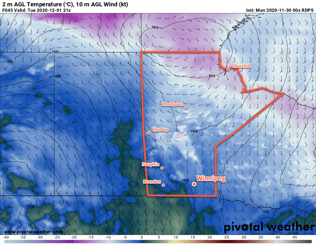
Temperatures climb right back to near the freezing mark this weekend, with even warmer temperatures likely building in to start next week. Cloudier conditions forecast to move into the region on Tuesday, followed by a return to seasonal temperatures near the end fo the week.

Today’s seasonal daytime high in Winnipeg is -7 °C while the seasonal overnight low is -16 °C.

Seasonably Mild Temperatures Return to Winnipeg

With the deep freeze locked up in the high Arctic, another push of Pacific air will bring seasonably mild temperatures to Winnipeg this week.

Winnipeg will see fairly benign weather over the coming days as an upper ridge spread mild Pacific air across the Prairies. The city will see plenty of sun today with southerly winds picking up into the 30–40 km/h range. Temperatures will climb to a high around -3 °C. The wind will keep up in the 20–30 km/h range tonight as temperatures dip to a low near -8 °C. A few clouds will push into the region tonight.

On Tuesday, the winds will gradually ease as temperatures climb to a high near -1 °C. The city should see partly cloudy skies for much of the day, but a trough approaching late in the day will bring increasing cloud to the region. Temperatures will dip to a low near -8 °C with skies staying on the cloudier side.

RDPS 2m Temperature Forecast valid 21Z December 1, 2020
Southern Manitoba will see seasonably mild temperatures to kick off December.

On Wednesday, cooler air will push into the region, bringing mostly cloudy skies with a high near -4 °C. There will be a chance of some light snow through the day with a light northwest breeze. Wednesday night should bring partly cloudy skies and a low near -8 °C.

Long Range Outlook

Another upper ridge will quickly rebound back over the western Prairies and spread eastwards through the rest of the week. Daytime highs will quickly climb back towards the freezing mark and stay there into next week. Some snow might be possible this weekend with a low that’s forecast to slide across the province, but there’s a fair amount of disagreement on its track. We’ll keep an eye on it heading towards the weekend.

Enjoy the beautiful late-November/early-December weather!

Today’s seasonal daytime high in Winnipeg is -6 °C while the seasonal overnight low is -15 °C.

Mild Temperatures Turn Cooler For Sunday

Winnipeg will see a couple more mild days before a cold front sweeps through the region.

Another push of mild air will push into southern Manitoba today as a low pressure system moves through the northern Prairies. It will bring more cloud to the region as temperatures climb towards a high near +1 °C. Winds will pick up out of the south to around 30 km/h for the afternoon then taper off in the evening. Some gusty winds will likely persist along the western escarpment into the evening hours as more warm air continues to push into the region. Temperatures will dip to a low near -5 °C with mixed skies tonight.

Winnipeg should see more cloud on Saturday with a few sunny breaks as temperatures climb back to +1 °C. A cold front will sweep through the Red River Valley in the evening, ushering in moderate northwest winds up to 40 gusting 60 km/h. Temperatures will drop quickly to a low near -11 °C with a bit of light snow moving through overnight.

RDPS 2m Temperature Forecast valid 03Z Sunday November 29, 2020
Mild temperatures will be ushered out of southern Manitoba on Sunday evening as a cold front sweeps through the region.

Sunday will bring significantly cooler temperatures to the region as an Arctic ridge moves through. Northwest winds near 30 gusting 50 km/h will continue for much of the day with temperatures rebounding slightly to a high near -9 °C. Skies will clear out through the day, followed by easing winds towards the evening. Winnipeg should see a low near -15 °C on Sunday night.

Long Range Outlook

Temperatures will climb back to seasonably mild values next week as an upper ridge redevelops and floods the Prairies with another wave of Pacific air. High should climb back into the -5 to 0 °C range with sunny weather turning cloudier midweek.

Today’s seasonal daytime high in Winnipeg is -6 °C while the seasonal overnight low is -14 °C.

Mild Weather Continues, Chance of Snow Tonight

Winnipeg will continue to see seasonably mild conditions through the rest of the week. A low moving through the province will bring a chance of light snow to the Red River Valley tonight.

A low pressure complex crossing the Prairies will bring more mild weather to Winnipeg today. Southerly winds picking up into the 30–40 km/h range will accompany temperatures climbing to a high near +1 °C. The city should see partly cloudy skies with thicker cloud moving in for the evening. Temperatures will dip to a low near -4 °C tonight with the winds easing overnight and shift westwards. A chance of light snow will develop overnight as a weak cold front pushes into the Red River Valley.

The chance for snow will taper off Thursday morning with cloudy skies giving way to some afternoon sunny breaks. Temperatures will barely be cooler than today with a high near 0 °C. Skies will stay cloudy tomorrow evening into the night as shortwave moves into the region as it digs southwards into the upper trough. This will bring another chance of some light snow to Winnipeg on Thursday evening. Skies will clear out through the second half of the night with temperatures dipping to a low near -9 °C.

RDPS 2m Temperature Forecast valid 21Z Wednesday November 25, 2020
Mild temperatures will move back into the Red River Valley today with highs climbing just above freezing.

Friday will bring more warm weather rot the city as another warm front pushes across the Prairies. Winnipeg should see partly cloudy skies as winds pick up out of the south in the afternoon into the 30–40 km/h range. Temperatures will climb to a high near +1 °C again. The wind will ease as it shifts westerly on Friday night and temperatures head to a low near -6 °C.

Long Range Outlook

Mild weather will stick around for Saturday, then a cold front is forecast to sweep through the province on Friday night. It will bring another chance of snow with it, then cooler temperatures will move into the region for Sunday and Monday. After that, it looks like Winnipeg will see a return to near-seasonal temperatures.afar

Today’s seasonal daytime high in Winnipeg is -5 °C while the seasonal overnight low is -13 °C.