Hot and Humid Summer Weather Comes to Southern Manitoba This Weekend

The heat will gradually amplify across southern Manitoba over the coming days as a hot and humid air mass builds into the province.
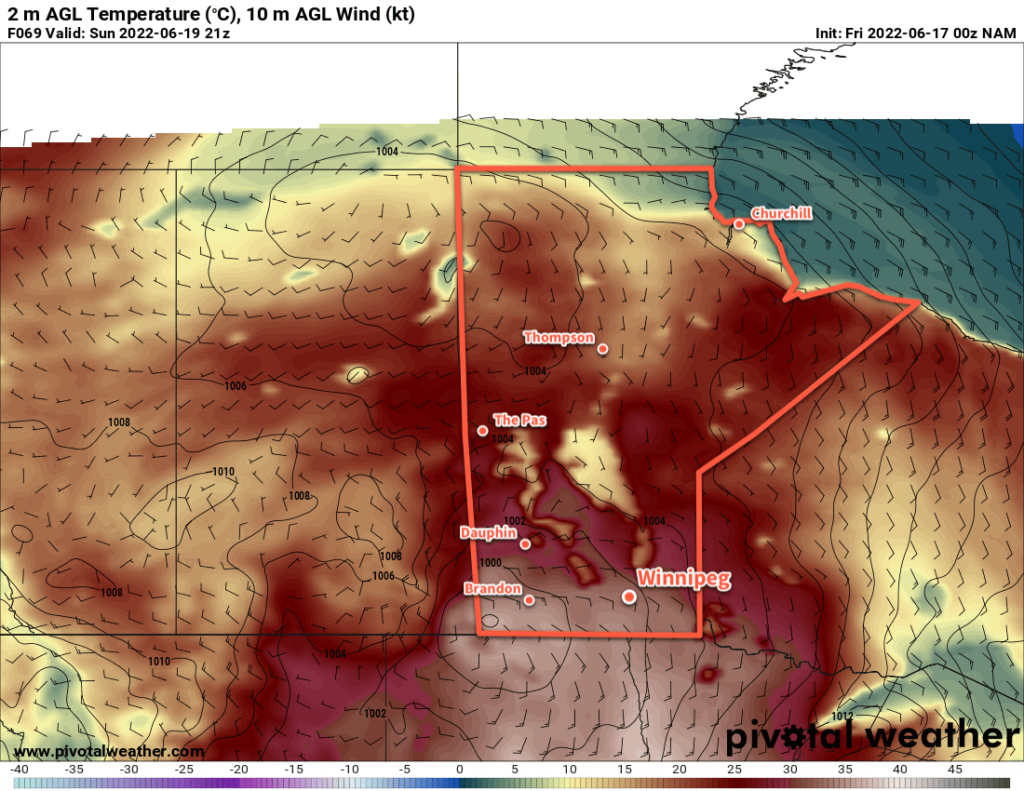
NAM 2m Temperature Forecast valid 21Z Sunday June 19, 2022
Very hot and humid conditions will move into Southern Manitoba by Sunday.

After a couple cool, windy, and showery days across the region, summer weather is quickly rebounding back into southern Manitoba. Driven by an intensifying upper ridge, Winnipeg will see near-seasonal conditions today quickly heat up into the weekend.

It will be a beautiful day in Winnipeg today with temperatures climbing to the mid-20s under sunny skies. Winds won’t be much of an issue, swinging around to the east for the afternoon and picking up to around 20 km/h. Humidity will stay comfortable through the day with dew points around 10 °C. Temperatures will drop into the mid-teens tonight with some cloud moving into the area as a warm front approaches.

Saturday will bring a cloudy start to the day with some showers or thunderstorms possible through the morning into midday. Some sunny breaks will develop in the afternoon as temperatures head to a high in the upper 20s. Winds will strengthen out of the southeast to around 40 km/h with gradually increasing humidity. The dew point will climb into the mid- to upper-teens by the end of the day as the warm air continues to push into the region. Temperatures will stay very warm on Saturday night, only dropping into the low 20s with a gradually diminishing wind.

Sunday will bring dangerous heat to southern Manitoba as the mercury soars and very humid conditions develop. With partly cloudy skies, temperatures on Sunday will climb into the low to mid-30s across most of southern Manitoba. As this happens, dew points will rise rapidly as the day warms up, increasing from the mid-teens up into the 20–25 °C range through the morning. This heat and humidity will produce humidex values of 40–45, making for weather that can be dangerous to be exposed to for extended periods.

In preparation for the heat, ensure that if you have air conditioning its in working order. Limit your exposure to the heat on Sunday, drinking plenty of water and ensuring you can find breaks to cool off whether it be indoors, shade, or other cooling opportunities such as city-run splash pads (great for the kids!). If you know anyone at risk for heat-related illnesses such as elderly individuals, those without air conditioning or access to cool spaces, or some with other forms of chronic illnesses, organize a plan to check in with them or provide some way of cooling off. Be sure to check out more information about preparing for and managing heat-related illnesses.

Sunday night will also stay very warm with overnight lows only dipping into the low 20s. Some showers or thunderstorms are likely on Sunday night, but they will likely avoid the Red River Valley. They should develop well to the west-northwest and likely pose a more notable risk to the Parkland and Interlake regions.

Long Range Outlook

Hot weather will continue on Monday, but it won’t be quite as extreme as seen on Sunday; highs in the low 30s will combine with dew points easing into the upper teens. This will produce humidex values of 35–40, which when combined with the second night of very warm lows may still be an issue for some. Conditions will turn more unsettled for the rest of the week as cooler air brings more seasonal conditions back to the region.

Today’s seasonal daytime high in Winnipeg is 24 °C while the seasonal overnight low is 11 °C.
Wind and Blowing Snow Usher in Warmer Weather

The Red River Valley will see another period of strong winds and blowing snow as a surge of mild Pacific air moves into the region.

Before the warmth arrives, though, the region will see another cold day today. Recovering from our cold morning, highs will climb to around -22 °C today under mainly sunny skies. The wind will stay light through the day as an Arctic ridge slumps over the region.

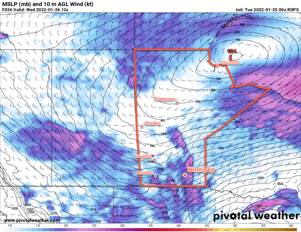
RDPS 10m Wind Forecast valid 12Z Wednesday January 26, 2022
Strong southerly winds will develop over the Red River Valley on Tuesday night.

Conditions will deteriorate tonight as southerly winds strengthen. With warmer air pushing in from the west, southerly outflow winds from the Arctic high will intensify. The wind will pick up to around 30 km/h by midnight, then to 50 gusting 70 km/h by Wednesday morning. These strong winds will combine with the loose snowpack to produce widespread blowing snow across much of the Red River Valley. White-out conditions will be possible in some areas. The worst of the blowing snow will likely be between 5 AM and 10 AM Wednesday morning, followed by improving conditions midday. Temperatures will rise close to the mid-minus teens by the time the sun comes up on Wednesday morning.

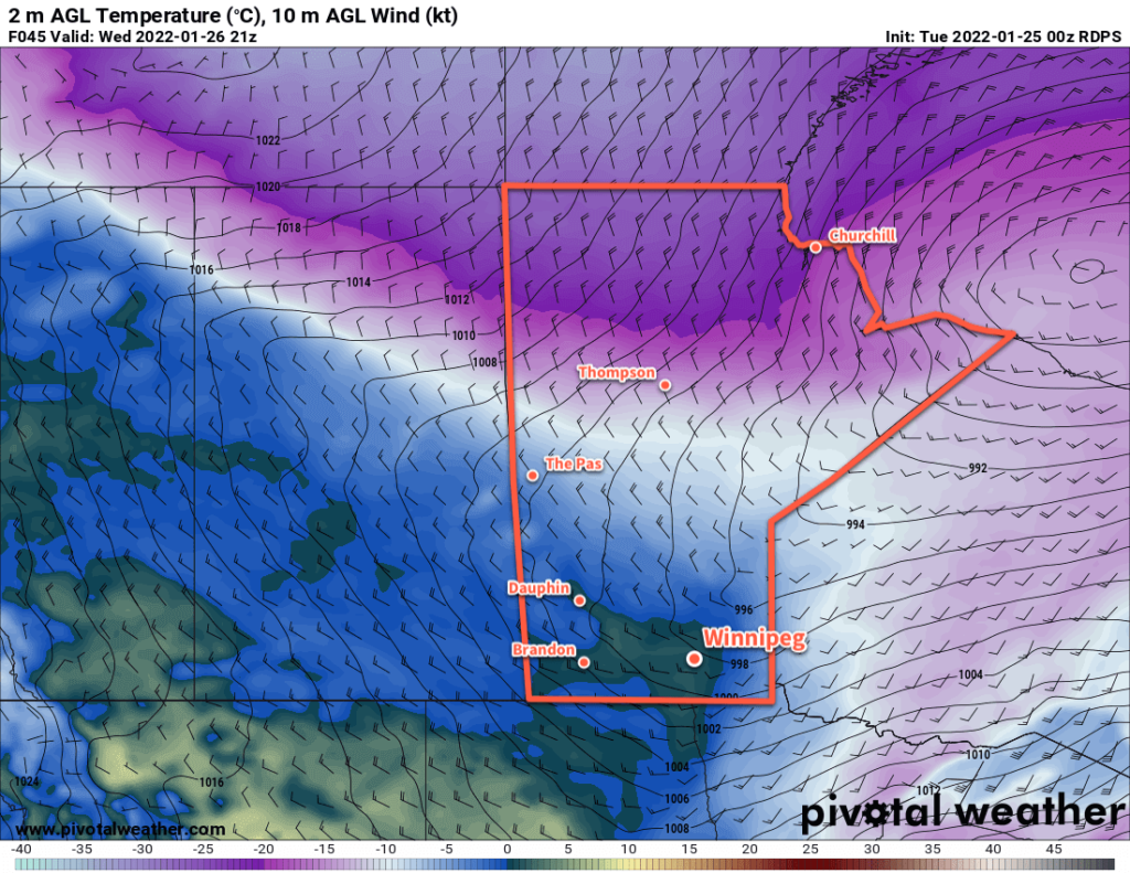
Temperatures will continue to rise as the wind and blowing snow eases. A warm front pushing through the region will shift winds towards the west through the day with a high climbing above freezing on Wednesday afternoon. The region should see a fair amount of cloud, but little by way of any notable snowfall.

RDPS 2m Temperature Forecast valid 21Z Wednesday January 26, 2022
Very mild temperatures will move through the Red River Valley on Wednesday afternoon.

A cold front will then slump through the region on Wednesday evening, shifting winds back to the north with some flurries. A bit of blowing snow is again possible on Wednesday night, but with after a mild day and with slightly weaker winds near 40 gusting 60 km/h, it shouldn’t be as extensive or severe as seen earlier in the day. Temperatures will head back into the -15 to -20 °C range for Thursday morning.

The Winnipeg area will see seasonably cool temperatures for the rest of the work week. Highs will sit near -15 °C with lows dipping into the -20 to -25 °C range. The city should see partly cloudy skies, but more cloud cover will work into the region on Friday evening.

Long Range Outlook

Cloudier conditions will move into the Red River Valley this weekend with seasonably mild conditions. A near-seasonal temperature trend will continue into next week with skies likely staying on the cloudier side.

The general long-wave pattern shows a consistent shift of the polar vortex back to the high Arctic. This should mean that, for the next little while at least, the extremely cold Arctic outbreaks should come to an end!

Today’s seasonal daytime high in Winnipeg is -12 °C while the seasonal overnight low is -23 °C.

Sunshine and Mild Early-Winter Warmth Ahead

Benign and pleasant early winter weather will settle in for Winnipeg this weekend.

The broad shift in the upper-level weather patterns we talked about earlier this week are underway. Gone is the Arctic vortex locked over Hudson Bay, allowing an upper ridge to build eastwards off the Pacific. This will be the dominant weather feature for the next couple days before it flattens out for the end of the weekend. Instead of being replaced by an upper trough and the associated cold air that comes with it, though, a generally zonal to west-southwest flow will develop aloft, continuing to spread mild temperatures across the southern Prairies.

As a result, Winnipeg’s forecast is quite pleasant for the days ahead. Right through the weekend into next week, the area will see daytime highs in the -5 to 0 °C range. A couple of these days may even see temperatures climb above freezing. Overnight lows will be similarly mild, generally falling in the -5 to -10 °C range.

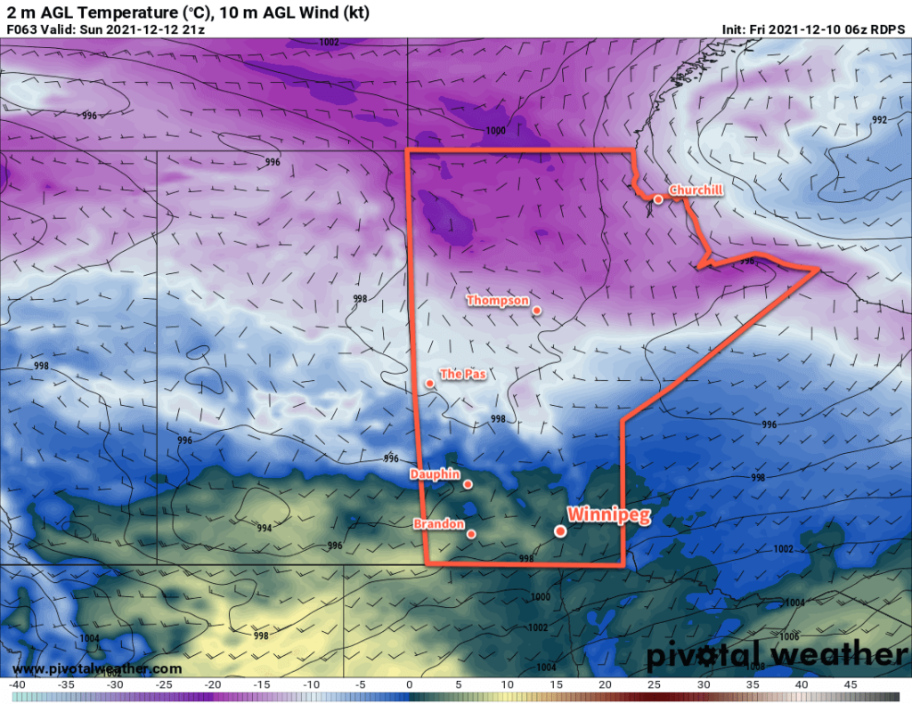
RDPS 2m Temperature Forecast valid 21Z Sunday December 12, 2021
Very mild December temperatures will spread across the southern Prairies this weekend. Most areas will see highs above freezing on Sunday.

Winds will be light for the region today, but for the weekend southerly winds around 20–30 km/h will develop. The windiest conditions should end up over the western Red River Valley where the escarpment can interact with the westerly component to the winds and produce slightly breezier conditions.

Along with these pleasant conditions will be plenty of sunshine; the Winnipeg area will see mainly sunny skies through the weekend. Some cloud cover will begin moving in next Monday and Tuesday.

Long Range Outlook

The next disturbance to impact the region will move through in the middle of next week. Forecasts show it could bring around 5 cm of snow to the region followed by breezy northwest winds and return to more seasonal temperatures. The overall weather pattern after that looks somewhat unsettled with a chance for more snow on Friday/Saturday and potentially again to start off the next week.

Today’s seasonal daytime high in Winnipeg is -9 °C while the seasonal overnight low is -19 °C.

Warm Week Ahead For Winnipeg To Bring A Wintery Mix

Early-season winter warmth will continue in Winnipeg, bringing pleasant conditions along with a mid-week wintery mix.

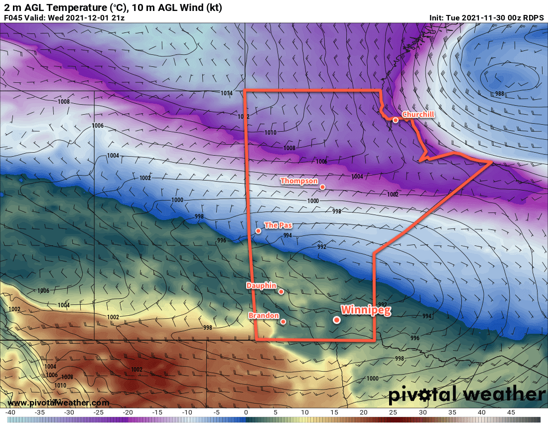
RDPS 2m Temperature Forecast valid 21Z Tuesday November 30, 2021
More early-winter warmth will spread across the southern Prairies this week.

A series of low pressure systems will cross the Prairies this week, spreading more mild air into the region. As a result, Winnipeg will continue to see seasonably warm this week. Daytime highs will sit in the -5 to 0 °C range, but Wednesday will bring temperatures above zero into the low to mid-single digits. Lows will also follow suit, staying several well above the seasonal normals.

The first low pressure system will begin moving into Alberta later today, pushing a warm front eastwards into southern Manitoba. This will spread an area of light snow into western Manitoba this afternoon that will move into the Red River Valley this evening. This system will produce a couple centimetres of snow as it moves through the region.

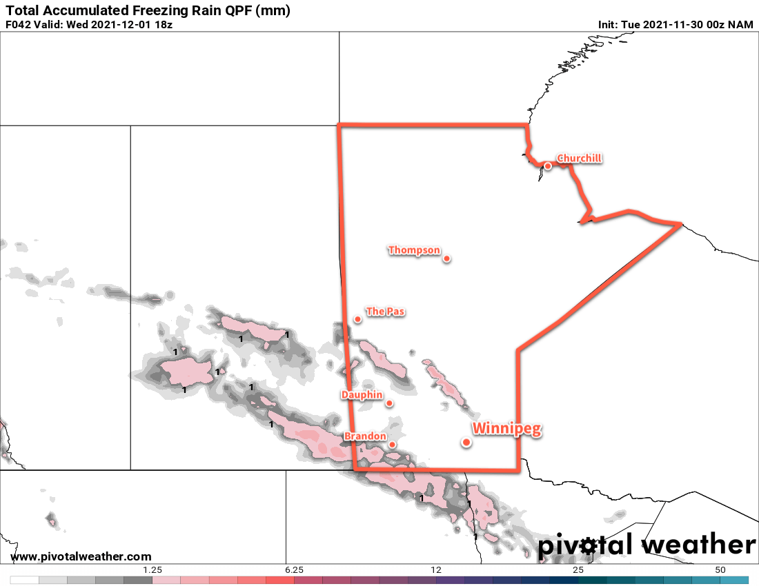
Alongside this, though, will come another risk of freezing rain. The risk will begin Tuesday afternoon in western and southwestern Manitoba. It will then spread into the Red River Valley overnight into Wednesday morning. The greatest threat for ice accumulation is over southwestern Manitoba, but slippery conditions will be possible throughout the risk area.

NAM Total Accumulated Freezing Rain Forecast valid 18Z Wednesday December 1, 2021
Although forecast models are outlining two areas of freezing rain on Tuesday/Wednesday, the risk will extend across much of southern and southwestern Manitoba.

Sunshine will be a relatively rare commodity over the coming week. Today will start off with plenty of sun, but once the cloud arrives later in the day, it’ll stick around through Thursday. A few sunny breaks are possible then, but no widespread clearing trend is likely until the end of the week.

Winds will be variable through the first half of the week, but a cold front passing through the region on Wednesday evening will usher in northwesterly winds near 40 km/h that should ease to light by Thursday morning.

A few more flurries will be possible Thursday night into Friday as another low pressure system crosses the province.

Long Range Outlook

Cooler air will filter into the region this weekend and send daytime highs into the -5 to -10 °C range. This shift in temperatures is forecast to persist into next week with near-seasonal overnight lows. Some more light snow is possible Saturday evening into Sunday, then again on Monday night.

Today’s seasonal daytime high in Winnipeg is -6 °C while the seasonal overnight low is -15 °C.