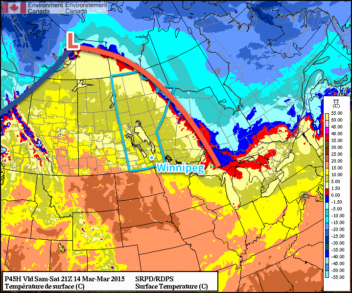
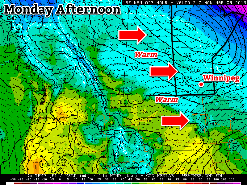
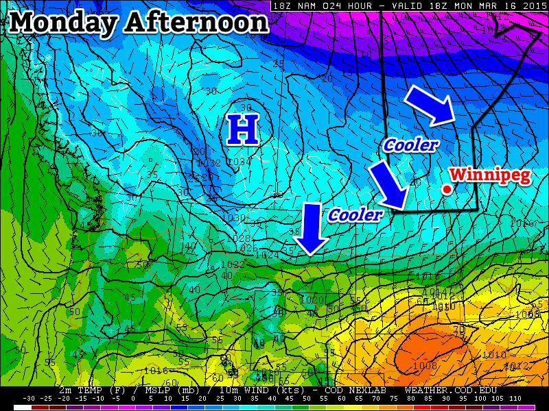
Beautiful Start To Fall Continues

Our beautiful start to fall – a start that has seen two days in a row a full 9–10°C above normal – will continue with well above-normal temperatures continuing through the week. A powerful storm system moving into Saskatchewan will lead to more unsettled weather as we move towards the end of the week, but rain is far from guaranteed here in Winnipeg.

Wednesday

Wednesday

25°C / 16°C
A mix of sun and cloud; windy out of the south.

We’ll see another pleasant but breezy day today under a mix of sun and cloud as some patchy cloud cover moves eastwards from a powerful storm system taking shape over central Saskatchewan. Temperatures should climb to around 25°C this afternoon as gusty winds pick up to 30–40km/h out of the south. The winds will let up a little bit overnight but will still be noticeable which, when combined with increasing cloudiness, will conspire to keep our overnight low around a balmy 16°C – which is coincidentally the average daytime high for this time of year.

Thursday

Total accumulated rain from the GDPS on Thursday 12Z - 00Z.

12 hour rainfall accumluations depicting rainfall during the daytime on Thursday. Under 2mm is forecast by the GDPS for Winnipeg.
Thursday

24°C / 12°C
Cloudy with gradual clearing. Chance of showers midday through the afternoon.

Thursday will bring mostly cloudy skies as the Saskatchewan storm edges eastwards slowly. While showers will push in over Western Manitoba, here in Winnipeg we’ll see just a slight chance of seeing some shower activity. The chance will start midday and last through much of the afternoon, but if we do get any rain it shouldn’t accumulate to anything significant.

The day will start mainly cloudy, but we should see mainly sunny skies by the evening as everything lifts off to the north. Our temperature will climb to around 24°C with winds around 30km/h diminishing through the afternoon. Thursday night will start with mainly clear skies but we’ll see increasing cloudiness by Friday morning as cloud streams in from the southwest ahead of yet another disturbance.

Friday

Friday

18°C / 7°C
Cloudy periods. Very slight risk of a morning shower.

We’ll see some cloudy periods on Friday as another disturbance spreads cloud ahead into Southern Manitoba. Our temperature will be a bit cooler; the daytime high is expected to hit around 18°C as a cold front pushes across the Red River Valley.

Friday night holds some promise of seeing some precipitation, which is rapidly becoming needed in Winnipeg. Only 4mm of rain has fallen in Winnipeg so far this September, not even 10% of the average of 45.5mm that falls in this month. The last significant rainfall in Winnipeg was the heavy thunderstorms that occurred through the morning of Sunday, August 18th which brought 15–30mm to the city. Since then, only 6mm of rain has fallen.

The GDPS is currently the only system that’s bringing rain into Winnipeg on Friday night, however there are some indications that other models could begin to fall in line with that thinking as well. Unfortunately, it’s going to be yet another system that has a very sharp cutoff on it’s edges. This system will be very sensitive to track, so we’ll be sure to keep an eye on things as they develop. Be sure to check back in the comments below for updates closer to the weekend.

Hot Weather Continues

The hot weather in place over the Red River Valley will stick around through the rest of the week, although a few more weak disturbances will bring in a little more cloud alongside the risk of a few showers or thunderstorms.

Wednesday

31°C / 18°C
A mix of sun and cloud. Humid.
Thursday

28°C / 18°C
A mix of sun and cloud. Humid. Slight chance a shower or thunderstorm.
Friday

27°C / 17°C
Mainly sunny. Chance showers or thunderstorms Friday night.

Today

We’ll see another hot and humid day today as temperatures climb into the low 30’s again with dew points hovering around 19–20°C. No precipitation is expected although we’ll see a mix of sun and cloud associated with a weak frontal system that wills be in the area.

Thursday

Tomorrow will be an interesting day; at this point it looks like we’ll see a fair amount of cloud in the morning before clearing out for the afternoon as an area of showers and thunderstorms moves across North Dakota and perhaps portions of the southern Red River Valley. Should this system push further north, there would be a slight chance of showers in the morning here in Winnipeg, but at this point I think that we’ll stay dry. Things will be pleasant in the afternoon as we climb to a high around 28°C before a weak upper-level cold front pushes into the Red River Valley. As it sweeps through in the evening, there will be a chance of some showers or thunderstorms pushing into the Red River Valley alongside it. Most regions in the RRV will see a chance of a shower or thunderstorm in the evening and overnight hours. Things will move out overnight as we drop to a low around 18°C.

Friday

Friday will be a beautiful day with mainly sunny skies and a high around 27°C. The humidity will drop off through the day as we heat up and are able to mix some of the remaining moisture near the surface out. There’s little threat of precipitation until the evening and overnight hours as low-pressure system pushes into Southern Manitoba, where thunderstorms will be possible with this system along a trough that will push through the Red River Valley. Depending on how things set up, there may be a slight risk of a severe thunderstorm with this system, so we’ll be sure to keep an eye on how things are setting up.

The Long Weekend

A preliminary look ahead through the long weekend looks beautiful. Skies should clear on Saturday morning and after that, it looks like nothing but sun, sun and more sun all the way through Monday. Highs look to be in the mid-to-upper 20’s, generally between 25–28°C with overnight lows dipping down to around the 12–13°C mark thanks to significantly less humidity in the air mass behind Friday night’s low pressure system.

Above-Normal Temperatures Continue

The above-normal temperature streak we’ve seen the past few days will continue through the rest of the week – albiet at a slightly moderated level – until a more unsettled pattern develops for the weekend.

Today & Tomorrow

Wednesday

26°C / 11°C
Mainly sunny.
Thursday

26°C / 13°C
Sunny.

We’ll see mainly sunny skies the next couple days as a ridge of high pressure slides across the province in the wake of the cold front that pushed through last night.

This ridge of high pressure will bring a break from the 30°C+ weather we’ve had the past couple days, bringing us back down to closer-to-seasonal temperatures in the mid–20’s. We should reach about 26°C each day which is still a couple degrees warmer than the seasonal average of 24°C for this time of year. The evenings will be quite cool, generally near 10–12°C although temperatures could potentially dip into the single-digits tonight in some areas.

Friday

Friday

27°C / 17°C
A mix of sun and cloud; slight chance of showers or thunderstorms.

We’ll see a regime change come Friday as a leading impulse approaches the province ahead of a developing long-wave upper trough over the west coast. A southerly flow will redevelop ahead of this impulse pushing moisture northwards out of the Northern Plains back into Southern Manitoba; as such, we’ll see a noticable increase in humidity as temperatures climb to around 26–28°C.

Precipitation is a bit of a wildcard at this point; some models bring a wide area of rain and thundershowers into the Red River Valley in the morning and persisting through much of the day until the impulse moves into NW Ontario while others keep much of the rain north of the RRV in the Interlake and bring thunderstorms in during the evening hours.

I think that most of the precipitation will push north of the city, but I certainly can’t rule it out at this point. We’ll definitely see a mix of sun and clouds, though. It looks like a chance for thunderstorms will persist through much of the evening and into the overnight period as well.

Long-Range Outlook

This weekend we’ll see warm, humid and generally unsettled weekend ahead with showers and thunderstorms likely Saturday & Sunday in Southern Manitoba.

NAEFS 8-14 Day Outlook initialized 2013-08-20 12Z

The NAEFS 8–14 day outlook shows slightly above-normal temperatures persisting in the 1–2 week timeframe.

Looking to next week, we will continue to see above-normal temperatures as a slack or southerly flow persists. We’ll also see dew points in the high teens making it feel relatively humid as well. After a month of below-normal temperatures, it looks as if we get to enjoy a late summer after all!

Mild and Settled

This week will start out mild, with little in the way of active weather.

image

NAM model predicted 500mb winds showing a slack flow through Southern Manitoba

A relatively stagnant flow will prevail over Manitoba for much of this week as the main storm track remains well to our south. This will give us seasonably mild temperatures and little if any precipitation.

Monday
image
Mainly sunny
-2°C / -16°C
Tuesday
image
Mainly sunny. Chance of flurries overnight.
-1°C / -8°C
Wednesday
image
Mainly cloudy. Chance of flurries.
-4°C / -18°C

Monday and Tuesday

Monday will be a pleasant day, with temperatures in the low minus single digits in most areas. There may be a few readings up near the zero degree mark in localized patches. There will be a light to moderate south wind through the day, but it won’t be particularly noticeable in most urbanized areas.

Tuesday will be almost identical to Monday, with temperatures once again generally around or just below zero. There may be patches of fog in Southern Manitoba again on Tuesday morning, but they will dissipate with daytime heating in the morning. The south wind from Monday will die off for the most part, making it a non-factor. A passing weather system may bring us some light snow on Tuesday night into Wednesday, but accumulations will be small.

Wednesday

As that system passes by on Wednesday morning, a weak cold front will go through, dropping temperatures slightly. This won’t prompt any kind of significant cool-down, but it will switch the wind to a slightly brisker northerly flow. Temperatures won’t change much however, with high temperatures in the low to mid minus single digits.

Long Range

In the longer range there is little to talk about. It appears we’ll cool down a bit towards week’s end, but otherwise models show no real trends over the next 7-10 days. No significant warm-ups are in the forecast, nor are there are major weather systems in the forecast. Unfortunately, this also means there is still no sign of spring…but at least there’s no sign of a nasty winter pattern returning either.