Elsewhere in Weather News: November 30th, 2013

Cyclone Lehar Hits India

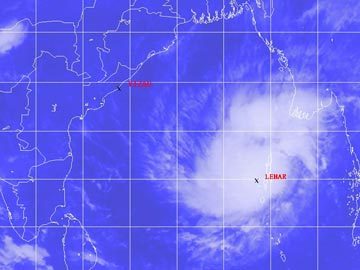
This past week a weak cyclone hit India’s east coast as a weak cyclone depression. The cyclone – Cyclone Lehar was classified as a severe cyclone in the Bay of Bengal with winds over 100km/h but has since been downgraded. Unfavorable sea surface temperatures and shear for storm development did a good job on tearing up the storm apart before landfall. The storm made landfall as a tropical depression on Thursday, with winds of 60-70km/h at landfall. Evacuation precautions were taken by the India Meteorological Department because of the strength of the cyclone while it was over the Bay of Bengal but the only real threat that Lehar brought was flood threat. No significant damage was reported from the storm but some crops have been damaged and a few districts vulnerable to flooding in India’s Andhra Pradesh state have been affected by flooding.


Cyclone Lehar as it was struggling to organize over the Bay of Bengal. (Source: NDTV)

Arctic air dominated over a good part of both Europe and the United States this week which brought minimal significant weather to the regions. Apart from significant snowfall associated with a trough of low pressure affecting the eastern seaboard of the United States earlier this week, active weather has been kept to a minimum. The next big weather event is likely to be a winter storm which will affect the northern states (MT, ND) and even southern Manitoba on Tuesday and Wednesday of next week.

Back To The Deep Freeze

After a short break from the cold as milder air spilled across the Prairies, significantly colder weather is on it’s way back to the region as a significant Arctic ridge pushes into the Prairies.

850mb Temperatures for Mid-Day Wednesday, January 30th 2013

850mb temperatures show a deep core of cold, Arctic air pushing into Manitoba while near summer-like warmth is in place over the eastern United States.

Wednesday

Wednesday

Mostly cloudy with patchy light snow.
-16°C / -25°C

The Arctic air will slowly push eastwards across Southern Manitoba today which will offset most of our potential warming today and limit our daytime high to only a couple degrees warmer than we dipped down to overnight. We’ll likely see the temperature climb to about –16°C today, but northerly winds of 20–30km/h will make it feel closer to –25 or –26 this afternoon. In addition to the cooler temperatures, some low-level lift associated with the advancing cold air, combined with the mostly cloudy skies in place over the Red River Valley, will result in patchy light snow for most of the day. As things cool off this evening the thermal profile will become less conducive to snow generation which will help any light snow left taper off. Temperatures will drop to around –25°C as skies clear overnight with wind chill values closer to –35.

Thursday & Friday

Sunny skies will dominate through to the weekend as we remain under the influence of the Arctic ridge. Temperatures will return back to the “bitterly cold” range with daytime highs back below the –20°C mark.

Thursday

Sunny.
-22°C / -33°C
Friday

Sunny. Increasing clouds overnight.
-24°C / -30°C

Temperatures will top out at –22°C on Thursday and then plummet to –33°C on Thursday night. Wind chill may be a concern on Thursday night; if winds climb up to even 15km/h wind chill values will drop to –42 to –45 which is below the –40 threshold for wind chill warnings in Southern Manitoba. Temperatures will rebound to only around –24°C on Friday under sunny skies again. Some cloud will push into the Red River Valley on Friday night as an Alberta clipper pushes into southwestern Manitoba; this will help prevent our overnight low from dropping as much as the night before. Currently it looks that the temperature will bottom out at –30°C but it will likely be short-lived as that cloudy, warmer air pushes eastwards.

Cold Weather Set to Return

We’ll see one (or two) more day of nice weather before things turn cold again, another arctic blast is on the way!

image

Manitoba will once again find itself right square in the middle of a major trough this week. This will allow another arctic air mass to surge down into Southern Manitoba by mid-week. This frigid air mass will be ushered in by an arctic front on Tuesday, whose arrival will be announced on Tuesday night with increasing north-westerly winds. However, before that happens we’ll see one final warm day on Monday.

Monday

Monday
image
Mainly cloudy. Risk of freezing rain or ice pellets.
-5°C / -12°C

Monday will be the warmest day this week, with high temperatures in the mid minus single digits in Southern Manitoba. There may be some light and sporadic freezing rain or ice pellets in Southern Manitoba on Monday morning. However, colder air aloft will move in later in the morning, turning any lingering precipitation to snow. The wind will be light on Monday, making it a comfortable day.

Tuesday

Tuesday
image
Mainly cloudy. Chance of flurries.
-10°C / -22°C

On Tuesday we’ll transition from early week’s warm weather to the colder weather that is in store for the rest of the week. As the arctic front approaches we may see a few flurries during the day on Tuesday. However, in general Tuesday looks like an OK day, with temperatures remaining slightly above seasonal and winds remaining fairly light. However, that will change Tuesday night as colder air begins spilling in…

Wednesday

Wednesday
image
Mainly sunny
-22°C / -32°C

We return to the deep freeze on Wednesday, with temperatures more or less flat-lining through the day at the morning’s low temperature. Wind chill values will be very cold as well. Wednesday night will be another frigid one, with temperatures expected to drop down around the -30C mark once again.

Models are somewhat ambiguous in terms of the long-range forecast. There is some indication that we may begin to warm up in early February, but there are other indications to suggest we may remain cold. It’s too early to say what is going to happen, so stay tuned for more updates as we go along.

Bitter Cold Continues

The bitter cold entrenched over Southern Manitoba will persist a few more days as another Arctic Ridge slides through the province.

850mb Temperatures valid Wednesday Morning

850mb temperatures valid this morning from the GEM-REG. A pool of bitterly cold Arctic air over the province will restrict daytime highs to the mid-minus-twenties today.

We’ll see an extremely cold day today with plenty of sunshine and a high only around –25°C. This is some 12–13°C below our normal daytime high for this time of year of –12°C. Temperatures will drop below –30°C tonight for a 3rd night in a row.

Light Snow on Thursday

Temperatures will continue to be cold on Thursday with a high near –21°C as a weak disturbance slides across the province in the northwesterly flow aloft. This will spread an area of snow across southwestern portions of the province early in the morning and into the Red River Valley near midday. With temperatures so low SLR values will likely be quite high, somewhere in the range of 20:1 to 25:1. This very high “fluffy factor” will help produce snowfall accumulations of 2–4cm by Thursday evening. Temperatures will climb to around –20°C on Thursday, aided by the cloud cover that will push in.

On Friday sunshine will return as we face another cold day with highs below –20°C. Fortunately, it appears that warmer air will finally be pushing into the region by Friday night. Temperatures look to drop only a few degrees from our daytime high as we then see much warmer weather on Saturday and Sunday as highs climb back towards the –12 or –13°C mark. It looks like we’ll see a mix of sun and cloud through the weekend, with a chance for another couple of cm of snow on Sunday.