A Little Snow Before The Coldest Weather This Winter

Two batches of snow followed by the coolest temperatures of the winter are in store for Southern Manitoba over the next few days.

Clipper Snowfall Totals

Forecast snowfall totals from this clipper system across Southern Manitoba.

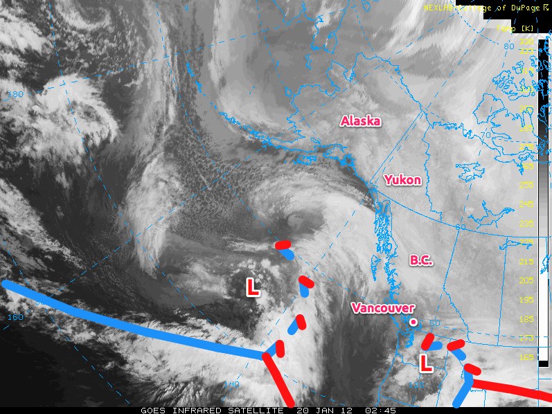
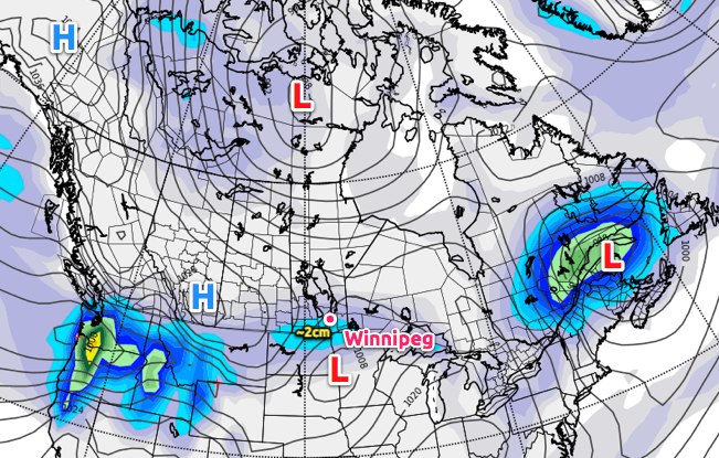
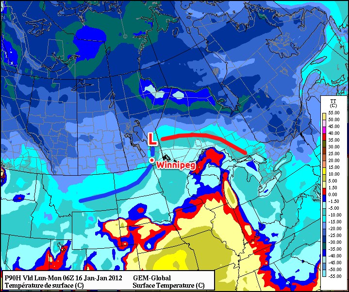
An Alberta Clipper will begin it’s march across the Prairies today, rapidly moving from Northern Alberta east-southeast into Northern Minnesota by tonight. This system will drag a warm front eastwards across Southern Manitoba, spreading 1–2cm of light snow across the Red River Valley. The snow will ease off this afternoon to just scattered light flurries as the weak leading impulse moves off into NW Ontario.

Temperatures will warm to around –8°C by this afternoon, with the warmer daytime highs near 0°C locked into the extreme SW portion of the province. A second shot of snow will push into the Red River Valley tonight as the main low centre of the Alberta Clipper moves through the region. Temperatures in the RRV will rise to –4 or –5°C by midnight before starting to drop as the cold front moves through. The bulk of the snow will start near midnight and taper off on Saturday morning with a further 3–5cm of snow accumulation for a total of 4–7cm by the time this whole system moves through.

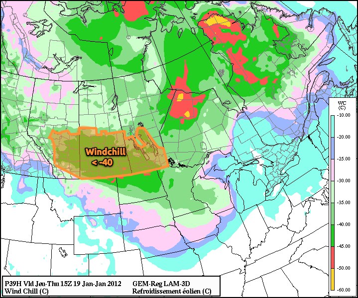
A few flurries will be around on Saturday as Arctic air begins building into Southern Manitoba yet again. Fairly strong northerly winds gusting up to 60–70km/h will develop early Saturday morning which will result in significant blowing snow in the RRV outside the City of Winnipeg. “Ground blizzard” conditions will be relatively widespread, with particularly poor visibilities as low as 100–200m on west-east running roads, such as the Trans-Canada Highway from Winnipeg to Portage La Prairie. Given the already slick conditions of many roads around the province, be sure to give yourself plenty of extra time if you need to travel on Saturday. The winds will lighten up by mid-afternoon, marking the start of our entry into a major deep freeze. Bitterly cold Arctic air will be pushing southwards behind this clipper system, with temperatures falling to around –25°C by the end of the day. Temperatures will plummet tomorrow night, with overnight lows through the Red River Valley dropping to the –30 to –35°C range. Temperatures will rebound slightly on Sunday as a weak disturbance brings some cloud and a chance of a flurry or two, but even colder air looks to be pushing in on Sunday night.

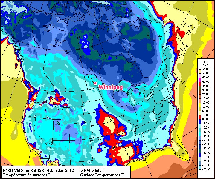
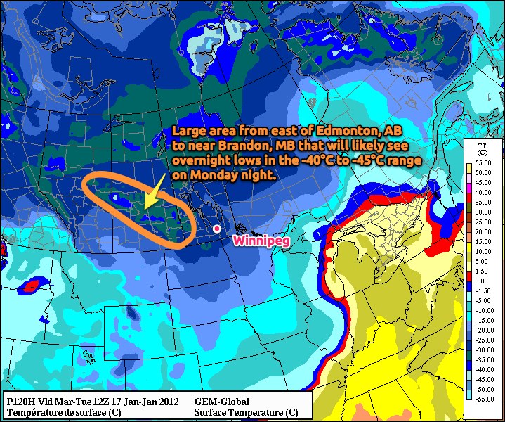
If the models are to be believed (which I do have some hesitation at the moment), temperatures will drop through the day on Monday to nearly –30°C by the end of the day, with overnight lows dipping to nearly –40°C. I think that the models are getting a little too excited about how cold it will get. The GEM-GLB model’s overnight lows have been 5–6°C too cold over the past week, so it’s more likely that we’ll see lows closer to –35°C than –40°C. At that point, though, it’s colds enough that those numbers don’t even matter. It’s certainly going to be an extremely cold start to next week.

The End of The Arctic Deep Freeze

After a couple days of bitterly cold temperatures, the end is already in sight for Southern Manitoba. Perhaps we shouldn’t complain, though, as Southern Manitoba got off pretty easy compared to the rest of Prairies, where temperatures plummeted to nearly -40°C through most areas, let alone considering the wind chill on top of that.

Pacific Analysis of Incoming System

Analysis of the Eastern Pacific, Jan. 12, 2012 02:45Z. A powerful low pressure system situated approximately 1000km off the British Columbia coast will bring a significant change to our weather pattern.

A powerful system pushing towards B.C. will bring a significant change to our weather pattern this weekend. As this system pushes into the western portions of the continent, the Arctic Vortex, currently situated near Baker Lake, NU, that has been pushing extremely cold air over the Prairies will begin to collapse and retrograde back towards the Gulf of Alaska.

As this happens, the large-scale flow over the Prairies will shift from northwest to southwest, and what a difference 60 degrees can make.

Temperatures will begin to rise on Saturday, as the arctic air begins to be pushed back northwards, and most areas in Southern Manitoba should see temperatures rise to around -12°C. Temperatures will continue to rise overnight and through Sunday up to around -5°C over the RRV as the actual low approaches.

We’ll likely see a couple of cm of light snow Friday night through Saturday as the warm front slowly lifts from North Dakota into the Interlake region. Past that, it gets a little tricky, as some models are forecasting substantial snowfall through Sunday while others keep all snowfall well north of the Trans-Canada Highway. Best case scenarios bring only light snow to the RRV on Sunday night in the wrap around for this system, while more pessimistic approaches bring close to 10cm of snow to our area through light-to-moderate snow through Sunday and Sunday night. It should start to become a little clearer over the next day or two, as the low approaches the coast. Currently, ensemble models predict that we’ll see little snow, and that accumulations should occur through the Interlake, and not as far south as Winnipeg.

After Sunday, we’ll cool back down to seasonal to slightly-above seasonal temperatures through much of next week, with daytime highs generally between -15°C and -10°C. All in all, next week looks quite pleasant. We’ll be sure to provide updates in the comments on how much snow we can expect for Sunday through the coming days!

Continued Cold This Week

Cold air will remain entrenched over Southern Manitoba for the remainder of this week, until a large scale pattern shift once again brings warmer than normal temperatures to our area.

January 18, 1800Z (Noon) MSLP & Snow Accumulation Prog

January 18, 1800Z (Noon) MSLP & Snow Accumulation Prognosis

Snow will taper off by early afternoon today as an arctic high pressure system builds into Southern Manitoba as it pushes across Southern Alberta and Saskatchewan. Much of Southern Manitoba will see a total of around 2cm of snow when all is said and done, with a few localities along the international border seeing 2-4cm.

The big story over the next couple days will be the ridge building across the Prairies. Southern Manitoba will see the coldest temperatures of the winter with daytime highs continuing to be well below normal.

The average daytime high for the 18th of January is -13°C. The average overnight low for the same day is -23°C. Winnipeg will experience temperatures close to 10°C colder than average over the next few days.

This high pressure system has brought bitterly cold temperatures to Alberta & Saskatchewan, with daytime highs of only -29°C in Calgary, -28°C in Edmonton and Saskatoon, and -27°C in Regina yesterday. This air mass will push into our region today, which will limit our daytime high to about -23°C and bring us our first overnight low below -30°C tonight.

January 19, 1500Z (9AM) Wind Chill Prognosis

January 19, 1500Z (9AM) Wind Chill Prognosis

Attached to this cold arctic air mass will be increasing northwest winds to 20km/h, which will produce bitter wind chill values below -40 overnight Wednesday and through much of Thursday morning. At those values, exposed skin can freeze in 5 to 10 minutes, so be sure to dress warm!

Why don’t wind chill values have a °C attached?

Wind Chill is a value calculated from a complex equation that takes the air temperature, the wind speed, and some empirically calculated values for heat transfer through skin into account. When the calculations are done, the units cancel out, and you’re left with a unit-less number. So while the equation was tweaked to produce numbers that resemble temperatures, they aren’t!

If the current forecast works out, it’s likely that we’ll see a large portion of the Prairies covered with wind chill warnings Thursday morning. Little changes for Friday, so there’s a good chance we’ll see another repeat of exceptionally cold daytime highs and bitter wind chills at night.

Current forecasts show a pretty substantial area of warm air pushing into the Southern Prairies on the weekend, bringing daytime highs up by 10 to 15°C. Combined with the CPC’s new forecast of above normal temperatures returning to Southern Manitoba, it doesn’t seem like this winter spell is long to stay.

Major Arctic Outbreak Next Week…But First, Milder Weather

Our shot of winter this week won’t look so bad by this time next week! Slightly warmer temperatures today will be followed by some light snow tonight and a dreary but milder weekend, before the coldest airmass we’ve seen this winter settles in over much of the Prairies.

Today will bring warmer temperatures as Pacific air pushes east-southeast across the Prairies. Temperatures should be able to make it up a little past the -15°C mark by early to mid-afternoon. Clouds will roll in by evening, and we should see some light snow in the evening and overnight with temperatures staying fairly steady overnight as warmer air continues to push into Southern Manitoba. Winnipeg will likely see 2-4cm of snow as relatively high snow to liquid water ratios (SLR) are expected, around 15:1 to 20:1.

Snow to Liquid Water Ratio (SLR) is a measure of how much snow is produced per millimetre of water. For example, a SLR of 20:1 would mean that for each 1mm of liquid water that fell, there would be 20mm, or 2cm. If someone received 10cm of snow, and that was melted and resulted in 4mm of water, then the SLR would be 25:1. The higher the SLR is, the ‘fluffier’ the snow.

Milder temperatures will be seen in the southwest and south-central portions of Manitoba on Saturday and Sunday. Temperatures will reach between -10°C and -5°C in the Red River Valley this weekend, with relatively light winds and plenty of cloud.

Surface Temperatures, Saturday Afternoon

Surface temperatures valid 12Z Saturday Morning (6AM)

We could see some light snow on both days as well, but significant accumulations (2+ cm) are unlikely. The days may be a little dreary, but enjoy the warmer temperatures while you can. Next week will be shockingly different.

Cold Front Passing Through Monday Morning

Surface analysis of forecasted temperature field valid 06Z Monday, Jan. 16. Warm front is represented by red line and cold front is represented by the blue line.

Early Monday morning, a cold front will sweep through Southern Manitoba, ushering in a completely different weather regime. We’ll see steady or dropping temperatures through the day Monday with some accumulating light snow through much of the RRV, especially north of Morris. Current indications show that 2-4cm looks reasonable, with 5-10cm possible for areas north of Winnipeg. Snowfall amounts in the City of Winnipeg will be sensitive to the exact track of the low, so we’ll keep an eye on that system as it develops.

The entire change will be driven by a long wave trough rotating southeast from Alaska into the Central Prairies. This will drive the jet stream south into the Northern U.S., allowing bitterly cold Arctic air to spill southwards into the Prairies. Just how cold is it going to get?

Bitterly Cold Temperatures Monday Night

Surface temperature prog valid early Tuesday morning, 12Z (6AM) January 17. Many areas in Southern Mantioba will see temperatures in the low -20’s with some spots in the southwest corner potentially reaching as cold as -32°C or -33°C. A wide swath of temperatures dipping below -40°C is forecast through Central Saskatchewan.

The coldest air we’ve seen all winter at 500mb will be pushing into the Prairies, with temperatures at that height forecast to be between -40°C and -45°C over most of the Prairies. What does this mean for temperatures at the surface? The GEM-GLB model is currently forecasting a swath through East-Central Alberta and Central Saskatchewan that will experience overnight lows between -40°C and -45°C!

For the third week of January, average daytime highs are around -13°C and average overnight lows are around -23°C. We will be several degrees below normal for a couple days next week.

This cold air will slump southeastwards bringing bitterly cold temperatures into Southern Manitoba, with overnight lows near -30°C and daytime highs struggling to climb above -20°C. By mid-week, temperatures may moderate into the mid-minus-teens as some cloud cover spills into the Southern Prairies associated with a system tracking through the Northern Plains. It may feel extremely cold, however, as we may be dealing with stiff northeast winds as the system moves through the area.

The cold air looks to be entrenched for the whole week, but we’ll have more on that on Monday. Get out and enjoy the weekend as best you can! It’s hot drinks and oatmeal weather next week!